Tuesday, December 31, 2013

Storm update...

Thursday storm, the Euro moved to the GFS solution:
 
The Monday storm is a DOOZY on the Euro (fingers crossed :) ) but the GFS once again slides it off south and east.  So, just for funsies, here is the Euro 24 hr snowfall map for Monday...

Monday, December 30, 2013

Significant (for us) disagreement

Between the GFS and Euro..

The GFS prognosis for Thursday's storm has it suppressed to the south and weaker:


While the Euro has more phasing between northern and southern jets bringing the storm more NE which will make any driving on Thursday a lot messier..

Likewise, the Euro is more gungho about next Monday's storm than the GFS..

Stay tuned.

Sunday, December 29, 2013

Another quick post

FYI as of 1:00 PM the temperature is -4C, a drop of 5C since this morning.
Tonight's dusting of snow is the southern edge of a heavier band going through central ontario into Que..  This energy will combine with a storm coming up the east coast to give New England and the Maritimes another blizzard.

Just as a heads up, it's going to be COLD this week.

Thursday/Friday storm looks like it will also pass south of us, giving the same people hit by the above storm another good dose.

Both the GFS and Euro are in fairly good agreement on another storm the Monday/Tuesday following.  Storms and rumours of storms...

Friday, December 27, 2013

Quick update

On the just for funsies storm a couple days after new years, the Euro has lost it and the GFS has found it.   So huge uncertainty after a few days out...

Wednesday, December 25, 2013

Merry Christmas..

All the best to you and yours from YFNWG this season and in the new year.

The week following the snow/ice storm of this last weekend has been and will continue to be fairly benign, albeit cold.  There will be a dusting of a few cms on Thursday as well as Sunday.  There is a risk that the main precip band of Sunday's system which is currently forecasted to be north of us will slip into our area.  If it does, then it will give us 6+ inches.

And just for funsies, the Euro is giving us a major storm a couple days after New Years.

Friday, December 20, 2013

Very messy situation on Saturday night/Sunday

Starting Saturday afternoon/evening in a line of precipitation start from southern to eastern Ontario coinciding with a frontal boundary.  Overnight Saturday, the storm will ride up this boundary with the heaviest precip in the Ottawa area will be predawn Sunday but will continue throughout the day.   The biggest question will be the type of precipitation.   It will start out as snow but as the temperature boundaries move around, it may become ice pellets and/or freezing rain.  I don't think we will get to straight rain as no model is putting surface temps above 0C.  The warm air coming from the south is pushing up against a dome of cold air to our NW.  So lower level temps will be colder than upper levels until after the storm passes.   If the upper levels can get cold enough, then the precip will be snow and not ice.

Here is A/W's snow map.  I have no major issues with it.  However, it favours the GFS/NAM solution.  Snowfall amounts will significantly depend on the mix of precip..  The Euro is further south with the amounts.  Yes, I am still rooting for the Euro.

Thursday, December 19, 2013

The Hobbit...

Lego style:

Blegh!!!

3:45PM Update... holding out for the Euro who's still giving us mostly snow...

Tomorrow's snow start in the morning.  It's now looking like 3-6 inches by Saturday morning.
Sunday's storm is getting uglier and unglier.   I keep hoping for a correction south on the models but the actual trend on Sunday's storm track is north.  Which puts us in an ice situation on top of snow, hence the title of this post.  As an aside, the storm is moving too quickly for another '98 Ice storm situation.

Wednesday, December 18, 2013

Update snow map...

NOT liking the trend in the modeling... just sayin'

Humpday Hilarity

Tickled my funny bone this...

Not much change from yesterday post...

Friday snow is looking like a 5-10cm event, depending on model.

Sunday's storm is still there.   There is a spread of solutions in the models, especially with regards to track.   The UK and Can tracking the low farther north through Ontario and the JMA well to the south and the GFS and Euro in the middle, just south of the lakes.   Right now, I would trust the GFS and Euro track over the others, based on quality of model.   However the GFS is splitting/stretching the energy out so that the precip bands are not as intense as the Euro.   As such, the Euro is still the most gung-ho storm forecast (see map below, again 24 hour snowfall totals for the period ending Sunday night).

Tuesday, December 17, 2013

First precip map for the Sunday storm


Quick morning post

Brrr..this morning was -26C at my house, -27 at the airport.   The thing about thermometers, errors are most often, if not all the time, on the positive side.   You rarely get a thermometer that reads colder than it actually is.

Anyway to the week's weather:
Warming up this week.
Friday's system has fizzled to some degree on the models.   It looks like the models were jumping to much energy on this system, thereby driving it north too soon.   It now looks to be an all snow event for Ottawa with temps staying below zero C.  It will start overnight Thursday in Southern Ontario.  There may be a mix of precip type in the Niagara peninsula and SW Ont.    For Ottawa, it's looking like about 5cm of snow on Friday.
The real deal will be on Sunday, where most models are in agreement about another system passing just south or over the lower Great Lakes.  The Euro (map below) is the most gung-ho about this one and if this comes to pass, there won't be much happening on Sunday, anywhere in southern and eastern Ontario.
The rest of Christmas week looks somewhat colder than normal but not extreme.

24 hr snow total in inches, ending Sunday night.

Saturday, December 14, 2013

Another updated weather map

It's just keeps getting better or worse.  However, this map is a little light in the west of Lake Ontario area as easterly winds are adding Lake Effect snow to the totals.  We have cancelled our road trip plans this weekend.

Friday, December 13, 2013

Updated snow for this weekend, and beyond...

Current trend in the models is throwing more moisture north hence the increased amounts:
Snow is expected to start in the Ottawa area Saturday afternoon.

Beyond this weekend: next week will gradually warmup due to a system heading through the western Great Lakes on Friday which is making for an ugly couple of days.   Currently it is looking like that system will cause (in the Ottawa area) precipitation to start as snow Thursday night, change over to freezing rain then to rain on Friday.  Then Friday night into Saturday, a strong cold front will pass through which will bring some more snow.   My biggest concern is a flash freeze situation, as it looks like temperatures will drop ~ 25 C in 24 hrs.

As always, stay tuned.

Thursday, December 12, 2013

Wednesday, December 11, 2013

The next while...

Cold for the next while.
Looks like we are only getting a dusting this coming weekend, as in a few cms of snow
Next weekend however, the models are in general agreement that there will a more significant system.   However exact track and timing are under debate...

And now for some perspective... Here is the estimated Lake Effect Snow totals over the next couple days.

Tuesday, December 10, 2013

Just for funsies...

Current GFS model map for Christmas Eve:
Which means this kind of precip:
 

The snow we're getting right now...

Are snow squalls originating from Georgian bay...
Fortunately (or unfortunately depending on your nature) these won't last long.   Looks like these will be done in an hour or so.   Just imagine if this lasted for hours as will happen for those in the lee of the lakes...

Monday, December 9, 2013

today...and beyond

Here is another example of Env. Can. publishing forecasts based purely on their model output and NOTHING else.  

Leading up to today's snow, Env. Can. was calling for a high temperature of plus 2C and a change over to rain before the cold front came through.   No other model that I see was calling for this change over.

Today's Env. Can.'s 5 AM and 11AM forecast continued in that vein.   However, I have just noticed a special release forecast (@12:07PM) that now has the high temp at 0C and no changeover to rain.   It's like someone just noticed that the temperatures weren't going up very much and stuck their head out the window and noticed it was still snowing.

Overnight lows not cold enough later this week in Env. Can.  We will be getting close to -20C at least on Thursday.

Next impact snow may be this weekend... Stay tuned

Sunday, December 8, 2013

Tomorrow's snow

Looking like about 2" (5cm-ish) of snow tomorrow.   There may be a bit of freezing drizzle but I don't think it'll change to outright rain like Env. Can. is showing.

Friday, December 6, 2013

The next week or so...

Yes, I've got posting back during the daytime... We'll see how long for.  Anyway, a quick one.
Getting colder over the weekend.
5-10 cm of snow on Monday.
Getting much colder midweek.
Potential for another system next weekend... stay tuned for that.

Wednesday, December 4, 2013

Accuweather has capitulated

and updated their December temperature forecast:

Score a half point for Weatherbell and my man Bastardi.  Next 1/2 point will how close the forecast will be to reality.

Monday, December 2, 2013

Bone chillin' cold...

But not here...  This week we are mild for us.  However, the western half of the country is going to experience some bone chilling cold over the next two weeks at least.   Some of it spills east this weekend and beyond but not nearly to the scope of what is happening in the prairies.   Alberta is currently getting hit with a blizzard which will be followed up with a true Arctic air mass with temperatures hitting close to 20 degrees below normal.  Putting that into real temps, that means most of prairies won't be getting any warmer than -20C for quite a few days...

Our next opportunity for significant snow looks to be next Monday.

Stay tuned.

Canadian and CFS December temp forecasts


Sunday, December 1, 2013

December temperature forecasts..

I subscribe to two private weather information services based out of the US, Accuweather and WeatherBell.  One of Weatherbell founders, Joe Bastardi was senior long range forecaster at Accuweather.   Which is interesting because their respective December temperature forecasts are quite different.

Earlier in November I had posted Weatherbell's forecast.  They've updated it, and it's even colder:


Here is Accuweather.


Interesting battle shaping up..

Wednesday, November 27, 2013

Snow day!!!

Snow will be done in a couple hours or so....But so far:

Weather summary for Southern Ontario and the National Capital Region issued by Environment Canada At 6:51 A.M. EST Wednesday 27 November 2013.

The following is a summary of weather event information received by Environment Canada.

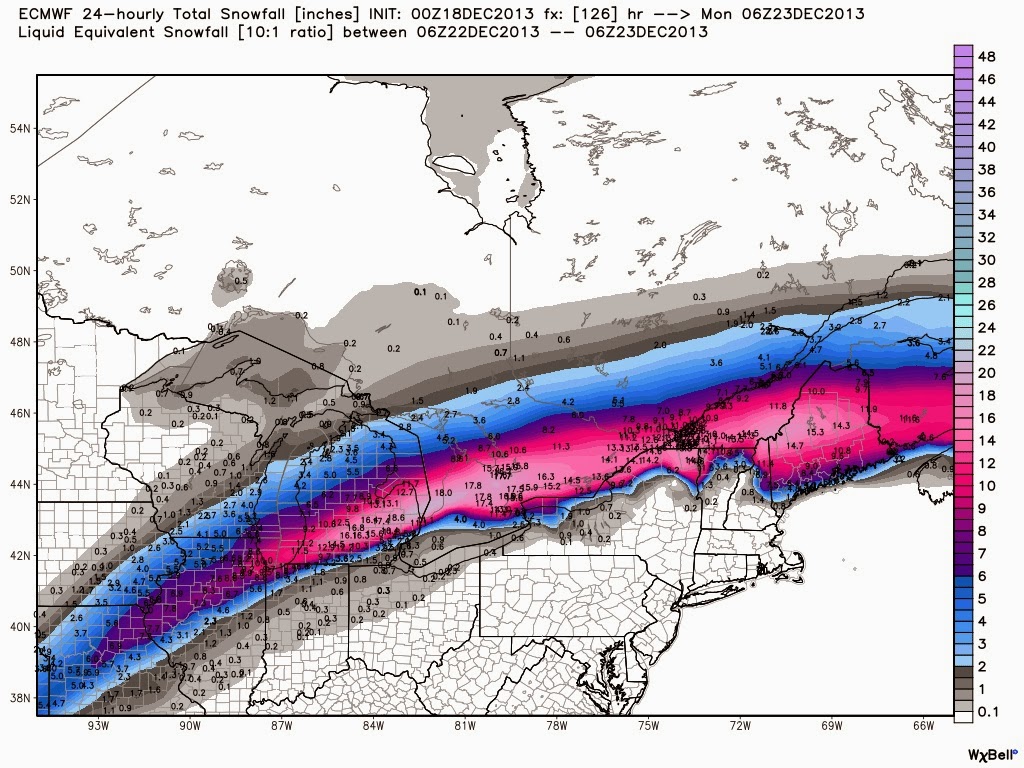
An early season winter storm has brought the first Major snowfall to much of Eastern Ontario as expected, with much of Eastern Ontario receiving 15 cm or more by early this morning. Snow fall warnings will likely be discontinued later today as the snow moves away with the storm centre into Quebec.

The Greater Toronto area was on the edge of this storm, with western portions receiving 2 cm or less, and 4 to 8 cm falling inland from Lake Ontario from about Yonge street and east.


The table below contains total snowfall amounts received by Environment Canada as of 6.00 AM.

Location                     snowfall amount
                              (centimetres)

Ottawa Airport                      20
Richmond (sw part of Ottawa)        18
Casselman                           23
Kemptville                          18
Alexandria                          15
Pembroke (estimated)                 6
Brockville (estimated)              14
Kingston                            15
Trenton                             14
Bancroft (estimated)                 7
Peterborough (estimated)             7
Whitby (estimated)                   6
Toronto Highway 401/Yonge            7
Buttonville Airport                  4
Pearson Airport                      2
St Catharines south end              8

Please note that this summary may contain preliminary or unofficial information and does not constitute a complete or final report.

END/OSPC

Tuesday, November 26, 2013

Monday, November 25, 2013

Winter storm watch from Env Can

Ottawa North - Kanata - Orléans
3:41 PM EST Monday 25 November 2013
Winter storm watch for
Ottawa North - Kanata - Orléans issued

First winter storm of the season Tuesday night into Wednesday.

A low pressure system over the Gulf of Mexico will bring the first significant snowfall of the season to much of Eastern Ontario Tuesday night and Wednesday.

Snow is expected to rapidly overspread the regions Tuesday evening, and then taper off from west to east on Wednesday.

Total snowfall amounts of 15 cm or more are expected in most places with up to 25 cm possible in the Ottawa area. An exception is in the St Lawrence Valley where warmer air could cause the snow to change to rain for a period, reducing amounts. There will also be the risk of freezing rain in easternmost sections.

Furthermore, some areas will see blowing snow on Wednesday.

Poor travel conditions are expected to develop Tuesday evening and continue into Wednesday.

Please refer to your local public forecast for further details.

A/W snow map

Hoowaaa!

Sunday, November 24, 2013

Skiff and a snow

Tomorrow night a skiff/dusting again of snow... looking like a little less than this past Saturday's.

Tuesday night into Wednesday has the potential to get us a thump of snow.   Interestingly the GFS ,who was offshore with the storm yesterday, has now flipped to the inside track and giving the interior NE US, eastern Ontario and southern Quebec a good storm.  It's giving us 8"+.   However the Canadian and Euro are a little less vigorous with a potential 6".    Will be keeping an eye on this one.

PS:  This is a excerpt from a SWS notice from Env. Can.:

Persistent snow squalls from Saturday afternoon through Sunday morning resulted in significant snowfall totals in a narrow band extending off of Southern Lake Huron, from around St Joseph (just
east of Grand Bend) southeastward through the west part of London. While this narrow band of snow did not affect any official Environment Canada weather monitoring stations, unofficial reports
received from the public suggest that up to 70 centimetres of snow fell in the hardest hit parts of this corridor.

Saturday, November 23, 2013

Interesting battle

In yesterday's post I showed a snow map.  Note the high accumulations on the eastern seaboard up into the western maritimes and eastern Quebec.   Most of that accumulation is coming from a storm they are predicting to ride up the east coast into New Brunswick and eastern Quebec Tuesday night into Wednesday.   The Euro still has that storm in this morning's model run with similar accumulations with a glancing blow to our area (1-2")  The GFS has the storm well enough offshore that it hardly the US but hits the Maritimes.   The Canadian is in the Euro camp.  It'll be interesting to see who wins out.

In other news, the snow guns of LES (Lake Effect Snow) are blazing away.  The Env Can. warnings are stating that accumulations in some areas could be 15-30cm per 12 hour period!!!

Friday, November 22, 2013

A hole in the snow

Right over us.   A map of the Euro snowfall total over the next 10 days..


Missing us right and left.... bummer.

Wednesday, November 20, 2013

Update on the weather

Looks like the plow-able snows have gone off the table for Friday night into Saturday.   We'll likely get a coating to an inch or so.  Very cold Sunday into Monday and another skiff of snow on Monday night into Tuesday.   Generally staying colder than normal into month-end into December.

Note the Lake Effect Snow guns are going to be firing on all cylinders for the next while.   Snow-belts will be buried, if you're going that way.

Message to all my loyal subscribers...

All six of you (ha!).

Recently my ability to post during weekday daytime hours has severely reduced to almost nil.    So short of getting a schmrt phone and posting with that, my posts during the week will be limited to evenings.  And since my evenings are soooo wide open (sarc), the posts may be limited to a couple a week.   I know, I'm bummed about too.  So be patient.   I am trying to work how best work this.

Monday, November 18, 2013

Snow on Saturday

Models are trending toward a shovelable snow event Friday night on into Saturday, depending on the model..
GFS: 4-6"
Euro: 6" plus 
Can: 3-5 "

Friday, November 15, 2013

This post will make me no friends

Looking towards winter.  Whilst I have not prognosticated about the coming winter on this blog, I have speculated with a couple of my friends what I'm looking at namely....

A snowier and colder winter than we have had of late, especially in the front end.   Naturally, things are more hazy farther out.  But I've been reading a lot of discussions and looking at the tendency in forecasts.   The trend for December has been toward a colder than normal December.  That usually means a snowier December as well as Ottawa will the in the battle ground between cold and warm.

The latest CFS:
A discussion of the Euro weekly forecast is here (Brett of Accuweather).  Both it and the GFS ensembles show that winter will start virtually now for the western provinces and cold air will become emplaced there.  How much of that cold air will make its way east to our area is the uncertain part.   With the North Atlantic Oscillation (NAO) also trending negative, that indicates more eastern troughs which will bring the cold east.

And then there's Weatherbell with my man Joe Bastardi whose forecast for December is to make everything cold.  FUN!  :)

Wednesday, November 13, 2013

Coming week...

My suggestion, for what it's worth, take it or leave it, is to get your final outdoor fall clean up done this Saturday.   It is going to be relatively mild and dry, even pleasant to be outside on Saturday.   Rake those leaves, clean those gutters, take in the garden hoses...

The rest of this week is going to get milder.  A system going NE through the western Great Lakes will bring precip late Sunday into Monday.   The cold front associated with this system will pass through late Monday into the overnight and so Tuesday and Wednesday will be much colder (like yesterday and today).

Back and forth pattern to continue the next couple of weeks, or so the models say...

Saturday, November 9, 2013

So it's snowing now...

It's the smattering of snow that earlier in the week I had thought would arrive Sunday.   Off by a day.   So sue me..

Snow cover update

As noted last week, the western provinces have largely been covered with snow.

Annnnnd it's gone...

The storm for later next week has dissppeared off the models, for good I think at this point.

I think the precip will hold off long enough for the Rememberance Day services to take place without getting wet.   Getting cold Tuesday.

Thursday, November 7, 2013

Still there...

Models flip flop away.  GFS currently doesn't have the storm late next week but the Euro had it, didn't have it, and now it has it again.   Currently the timing is Thursday evening into Friday with the Euro printing out about 8-10 inches of wet snow.   Fun!

Tuesday, November 5, 2013

Something to keep an eye out

Forget Sunday (which by the way the Euro and Can. is still predicting a smattering of snow).   Next Wednesday into Thursday is predicted to have some very interesting weather according to BOTH the Euro and the GFS.  Let's just say I may get my snow tires on sooner rather than later.   Here is a map of snow accumulation in inches next Wednesday evening, with the bullseye right over Ottawa.

Monday, November 4, 2013

T.D.o.S

Booya

This week.

Warming up until a rain event Wednesday evening into Thursday morning with a return to cooler temperatures thereafter.
Interesting alliance happening with respect to next Sunday's weather.  The Canadian model is allied with the Euro for a possibility of snow on Sunday whilst the GFS gives us mostly another rain event.

Friday, November 1, 2013

Canadian snow cover.

An update to my "prediction" wrt to Canadian snow by the end of October, here is the map of snow cover as of yesterday.  While there was some melting from a few days ago, the snow cover fell short of my prediction.   However, over the next week, the western half of the Country will get a lot whiter.

Wednesday, October 30, 2013

Scary weather tomorrow

Rainy and windy...

Potential of snow smattering again sunday afternoon..

A little surprise this morning

Huh.   That skiff of snow surprised this morning even me.

Update...nice english on me, eh?

Sunday, October 27, 2013

Env. Can. comes around to the other models...again.

Note the predicted low temps for Tuesday morning:  -8C

Trick'r'treat-ing still looking damp.

Thursday, October 24, 2013

The next bit

Saturday:  still not a nice day
Monday:  weak cold front coming through bring showers/flurries..
Tuesday:  cold day, not getting much above zero.  Definitely colder than Env. Can. calling for currently (7 and 1 for high and low temps)
Beyond Tuesday, significant divergance in the modeling.  GFS keeps the jet suppressed so we have a ugly Halloween.  The Euro on the other hand has a relatively nice day next Thursday...so who knows...

Lake Effect snow...

This cold out break is having effect...

Snicker...

MSM is johnny-come-lately to the story..my posts:
http://yfnwg.blogspot.ca/2013/08/tropical-storm-season-update.html
http://yfnwg.blogspot.ca/2013/09/update-to-tropical-storm-season.html
http://yfnwg.blogspot.ca/2013/09/tropical-season-update.html
http://yfnwg.blogspot.ca/2013/09/update-to-tropical-season-update.html

Wednesday, October 23, 2013

Quick post

Ottawa A/P got to 0C this morning.   Bancroft had a low of -3, Petawawa -2.

Hard frost the next couple of mornings. 
Saturday afternoon/evening will be gross, ie cold and damp.
Coldest period next week will be Tuesday night/Wednesday morning with a "hard" freeze, ie negative mid single digits.
Looking hopeful for the trick'o'treat-ers with a possible window of milder air before some precip.

Monday, October 21, 2013

Sunday, October 20, 2013

Is it going to freeze this week?

The current Env. Can forecast for Ottawa has no temperatures below 0 C, with morning lows hitting zero Wednesday and Saturday.

On other hand, both the GFS and European model have morning low temperatures below zero Thursday through Saturday mornings, and maybe as soon as Wednesday.

How much faith do I have in Env. Can. temperature forecast?   Cover the plants you don't want to freeze.   Just sayin'.


PS.  TWN has Saturday morning @ -2.   That a bit better.

Tuesday, October 15, 2013

Last half of October

Blegch!!

It will not be pretty.. Think a typical Fraser Valley winter, hovering around the freezing mark, daytime highs a few degrees above, night-time lows a few degrees below,  possible rain/sleet and snow showers...

This pictures tells a few words..

Monday, October 14, 2013

Snow cover

Here is the current North American snow cover.

It is my prediction, based on what I see on the models, that 80-90% of the country (Canada that is) will be covered with snow by the end of October.

Happy Thanksgiving!

Saturday, October 12, 2013

The next week or so...

I hope most of you took advantage of today's weather to take a walk somewhere naturey...because this ain't gonna last...  Brilliant forecast, I know.

This weather will last to about tomorrow evening when the first of series of three cold fronts will drag in a trough for next weekend.   The second cold front is Wednesday and the third is Friday/Saturday (note that the Euro model is dragging its feet about the last one in comparison to the GFS, but late isn't denied).

If this comes true then the latter part of next week will be miserable, ie cool and wet. There is also a definite chance for a hard frost early in the week of the 20th.

Friday, October 4, 2013

Be thankful it's only rain

The precipitation we are getting over the next few days is due to a system that is currently giving a blizzard the US midwest.

Like I said, be thankful it's only rain.  It could be worse.

Wednesday, October 2, 2013

Quick post...

Nice until Friday or Saturday when rain will come and somewhat cooler temps.  Rain will last until Monday.    The remainder of next week will again see mild temperatures until a cold front on the weekend will bring that to an end to that.  On the backside of this front there may be the f-word....flurries, according to one model anyway.

Tuesday, October 1, 2013

Over the Misty Mountains cold


Phew!!!!!

More IPCC report reactions

http://climateaudit.org/2013/09/30/marotzkes-broken-promise/
http://climateaudit.org/2013/09/30/ipcc-disappears-the-discrepancy/
http://judithcurry.com/2013/09/28/ipcc-diagnosis-permanent-paradigm-paralysis/
http://judithcurry.com/2013/09/29/how-the-ipcc-forgot-to-mention-the-pause/
http://judithcurry.com/2013/09/30/ipccs-pause-logic/
http://judithcurry.com/2013/10/01/ipcc-solar-variations-dont-matter/
http://judithcurry.com/2013/10/01/negotiating-the-ipcc-spm/
http://fullcomment.nationalpost.com/2013/09/27/kelly-mcparland-the-uns-latest-climate-change-report-could-serve-to-close-the-door-on-windbaggery/
http://opinion.financialpost.com/2013/09/30/ipcc-climate-global-warming/
http://www.drroyspencer.com/2013/09/ipcc-we-dont-need-no-stinking-climate-sensitivity/
http://www.drroyspencer.com/2013/09/the-global-warming-they-fear-is-not-based-upon-physical-first-principles/
http://rogerpielkejr.blogspot.ca/2013/09/five-points-on-ipcc-report-wonky-long.html

From the last article:
"5. There is not a strong scientific basis for claiming a discernible effect of human-caused climate change on hurricanes, floods, tornadoes or drought."

What's left for CAGW?  Maybe only the AGW part, in part....

Friday, September 27, 2013

The next week or so

Besides a dying cool front of Monday, our streak of nice weather continues until next weekend, the forecast of which makes me very glad I'm having the Fall Classic this weekend rather than next.

Friday Funny

And if I have to explain this one to you...here's a clip from Toy story.

Update to Sea Ice update.

Most datasets have the 2013 Arctic Sea Ice minimum extent as the highest since 2006 except for 2009:

And oh by the way, the Antarctic Sea Ice maximum is at record high values:

New Summary for Policy Makers (SPM) from the IPCC

With the MSM falling over themselves to proclaim how certain scientists are that man is causing global warming...

Some reactions:
http://judithcurry.com/2013/09/27/95/
http://nofrakkingconsensus.com/2013/09/27/9000-nobel-pretenders/
http://www.staatvanhetklimaat.nl/2013/09/27/ar5-gives-no-best-estimate-for-climate-sensitivity-breaks-with-a-long-tradition-good-news-is-hidden-from-policy-makers/
http://www.bishop-hill.net/blog/2013/9/27/thoughts-on-the-spm.html
http://bobtisdale.wordpress.com/2013/09/27/side-by-side-comparison-of-draft-and-final-ipcc-ar5-spm-on-warming-plateau-and-attribution/
http://wattsupwiththat.com/2013/09/27/ipcc-fails-to-come-clean-over-global-temperature-standstill/
http://wattsupwiththat.com/2013/09/27/new-ipcc-climate-report-already-obsolete-2/

I think it also helpful to note that there is a much less emphasis on GHG (greenhouse gases) such as CO2, but also on "other" anthroprogenic changes.  As touched on by Judy Curry post, what will the IPCC say when the current 10 year negative trend (not pause) extends out to 15 or 20 years (as I think it will)?  Will they admit that they were wrong?...not bloody likely.

As I comment in the national post article: This report is out of date already, stillborn, as recent studies that didn't make the deadline for incorporation into this report ARE cast doubt on the severity of AGW. The only way that the IPCC can raise their certainty is by being more certain about a more vague criteria...

But one of my favourite reaction is Ross McKitrick's comment here:

SPM in a nutshell: Since we started in 1990 we were right about the Arctic, wrong about the Antarctic, wrong about the tropical troposphere, wrong about the surface, wrong about hurricanes, wrong about the Himalayas, wrong about sensitivity, clueless on clouds and useless on regional trends. And on that basis we’re 95% confident we’re right.

Tuesday, September 24, 2013

Questions for the IPCC

Marcel Krok, a Dutch scientist and blogger has an interesting post where he lists five questions he would put to the IPCC.  There are probably many a skeptic would like to see definitive answers to these questions.

Dr. Curry has a cross post where she adds one more...

Monday, September 23, 2013

Update to the Tropical Season update

Hurricance forecasters are doing some soul searching after predicting a very active season.
A pic and table tell the tale:

Sunday, September 22, 2013

Welcome to Autumn

The fall Equinox occurred this afternoon.

Yesterday...

So my wife and I didn't go camping...due to the weather.
Good thing.  Belleville, relatively near to Sandbanks P.P., had 30 mm of rain yesterday, well over an inch...
Current forecast for the Fall Classic, mild and dry. Woot!

Thursday, September 19, 2013

Timing

In weather forecasting timing is key.  You can get the weather right but be off by a few hours and you've blown the forecast.
In planning events, timing can be a b#&$h.   My wife and I are planning a small two-nighter camping getaway starting tomorrow.  As my post Monday indicated, there looks to be weather that will put a damper (haha) on the trip.   Most of the full day that we are away will be cloudy and showery.   IF ONLY the weather that we've had yesterday and today had been a mere two days later...but noooooo.. grumble, grumble, grumble...

Wednesday, September 18, 2013

Next IPCC report

Most of you are probably not aware of this, but the UN organization for Climate Change, the IPCC,  is shortly issuing their next report (done every four years), AR5, supposedly showing the current state of climate science.   As you might expect, there is a lot of controversy about it with various "leaks" coming out.   If you're interested, here are some articles about it:

http://opinion.financialpost.com/2013/09/16/ipcc-models-getting-mushy/
http://fullcomment.nationalpost.com/2013/09/16/matt-gurney-climate-scientists-it-wont-matter-if-youre-right-in-the-end-if-no-one-believes-you/
http://online.wsj.com/article/SB10001424127887324549004579067532485712464.html?mod=WSJEurope_hps_MIDDLE_Video_second
http://wattsupwiththat.com/2013/09/17/ridleys-riposte-to-john-abraham/
http://rogerpielkejr.blogspot.ca/2013/09/global-temperature-trends-and-ipcc.html
http://judithcurry.com/2013/09/17/consensus-denialism/
http://judithcurry.com/2013/09/15/leaked-ipcc-report-discussed-in-the-msm/
http://www.drroyspencer.com/2013/09/a-turning-point-for-the-ipcc-and-humanity/
http://wattsupwiththat.com/2013/09/15/the-state-of-climate-science-fluxed-up/
http://wattsupwiththat.com/2013/09/15/one-step-forward-two-steps-back/
http://wattsupwiththat.com/2013/09/16/lomborg-climate-models-are-running-way-too-hot/
http://wattsupwiththat.com/2013/09/16/what-people-will-read-and-see-with-the-ipccs-lead-off-illustration-from-the-ar5-spm/

That's for starters...

Monday, September 16, 2013

Late week outlook

Currently there is fairly strong agreement that will come through Friday evening into Saturday morning bring showers, potential thunderstorms and cooler temps.  It'll clear during the day on Saturday and will be sunny but cool for a few days.  According to at least one model, we will have our first frost at some point during the first half of next week.

Friday, September 13, 2013

Quick post

Saturday, clear but cool
Sunday, cold front coming in late in the day bringing chance of showers, maybe with some thunder
Monday should clear out but cooler (risk of frost Monday or Tuesday morn)
Clear until Thursday-ish when the models are starting to get a little muddled as to what's happening.

Colorado floods

You may have heard in the news about the flash flooding in Colorado.   Here is the total rain the SW US over the last 7 days.

At least is will help the so called "permanent drought".

Tuesday, September 10, 2013

Tropical season update..

Wednesday morning update.  It's official, Humberto has tied Gustav for the latest first hurricane of the season.

The record for the latest development of the first Atlantic hurricane of the season is Gustav in 2002 which formed September 11th.
This year Humberto is challenging that record.  It currently is moving west of the Cape Verde islands in the east Atlantic far away from anything, still classified as a tropical storm.  Most experts see Humberto gaining hurricane characteristics within 24 hours.

Regardless, the season has been/is really slow to start with the ACE (accumulated cyclone energy) at 20% of average.

Things that make you go "hmmmm".

11:00 AM forecast for Ottawa's high temperature today is 27 C.
1:00 PM temperature reading at Ottawa airport:  15 C.

Think the forecast high will be reached?   Methinks not.

Sunday, September 8, 2013

Quick note

Env. Can currently has 30 and 29C for forecast highs on Tuesday and Wednesday respectively.   While it will be humid, it will also be overcast and raining, keeping temperatures muted.   So currently I'm sided with TWN which has highs in the 27C range for those days.

Thursday, September 5, 2013

And oh by the way...

Antarctic sea ice is at record high levels.

Canadian Arctic Sea Ice

With temperatures averaging well below zero in most areas:
the melt has pretty much stopped in the Canadian Arctic:
and new ice has begun to form (pink areas):