Tuesday, December 31, 2013

Storm update...

Thursday storm, the Euro moved to the GFS solution:
 
The Monday storm is a DOOZY on the Euro (fingers crossed :) ) but the GFS once again slides it off south and east.  So, just for funsies, here is the Euro 24 hr snowfall map for Monday...

Monday, December 30, 2013

Significant (for us) disagreement

Between the GFS and Euro..

The GFS prognosis for Thursday's storm has it suppressed to the south and weaker:


While the Euro has more phasing between northern and southern jets bringing the storm more NE which will make any driving on Thursday a lot messier..

Likewise, the Euro is more gungho about next Monday's storm than the GFS..

Stay tuned.

Sunday, December 29, 2013

Another quick post

FYI as of 1:00 PM the temperature is -4C, a drop of 5C since this morning.
Tonight's dusting of snow is the southern edge of a heavier band going through central ontario into Que..  This energy will combine with a storm coming up the east coast to give New England and the Maritimes another blizzard.

Just as a heads up, it's going to be COLD this week.

Thursday/Friday storm looks like it will also pass south of us, giving the same people hit by the above storm another good dose.

Both the GFS and Euro are in fairly good agreement on another storm the Monday/Tuesday following.  Storms and rumours of storms...

Friday, December 27, 2013

Quick update

On the just for funsies storm a couple days after new years, the Euro has lost it and the GFS has found it.   So huge uncertainty after a few days out...

Wednesday, December 25, 2013

Merry Christmas..

All the best to you and yours from YFNWG this season and in the new year.

The week following the snow/ice storm of this last weekend has been and will continue to be fairly benign, albeit cold.  There will be a dusting of a few cms on Thursday as well as Sunday.  There is a risk that the main precip band of Sunday's system which is currently forecasted to be north of us will slip into our area.  If it does, then it will give us 6+ inches.

And just for funsies, the Euro is giving us a major storm a couple days after New Years.

Friday, December 20, 2013

Very messy situation on Saturday night/Sunday

Starting Saturday afternoon/evening in a line of precipitation start from southern to eastern Ontario coinciding with a frontal boundary.  Overnight Saturday, the storm will ride up this boundary with the heaviest precip in the Ottawa area will be predawn Sunday but will continue throughout the day.   The biggest question will be the type of precipitation.   It will start out as snow but as the temperature boundaries move around, it may become ice pellets and/or freezing rain.  I don't think we will get to straight rain as no model is putting surface temps above 0C.  The warm air coming from the south is pushing up against a dome of cold air to our NW.  So lower level temps will be colder than upper levels until after the storm passes.   If the upper levels can get cold enough, then the precip will be snow and not ice.

Here is A/W's snow map.  I have no major issues with it.  However, it favours the GFS/NAM solution.  Snowfall amounts will significantly depend on the mix of precip..  The Euro is further south with the amounts.  Yes, I am still rooting for the Euro.

Thursday, December 19, 2013

The Hobbit...

Lego style:

Blegh!!!

3:45PM Update... holding out for the Euro who's still giving us mostly snow...

Tomorrow's snow start in the morning.  It's now looking like 3-6 inches by Saturday morning.
Sunday's storm is getting uglier and unglier.   I keep hoping for a correction south on the models but the actual trend on Sunday's storm track is north.  Which puts us in an ice situation on top of snow, hence the title of this post.  As an aside, the storm is moving too quickly for another '98 Ice storm situation.

Wednesday, December 18, 2013

Update snow map...

NOT liking the trend in the modeling... just sayin'

Humpday Hilarity

Tickled my funny bone this...

Not much change from yesterday post...

Friday snow is looking like a 5-10cm event, depending on model.

Sunday's storm is still there.   There is a spread of solutions in the models, especially with regards to track.   The UK and Can tracking the low farther north through Ontario and the JMA well to the south and the GFS and Euro in the middle, just south of the lakes.   Right now, I would trust the GFS and Euro track over the others, based on quality of model.   However the GFS is splitting/stretching the energy out so that the precip bands are not as intense as the Euro.   As such, the Euro is still the most gung-ho storm forecast (see map below, again 24 hour snowfall totals for the period ending Sunday night).

Tuesday, December 17, 2013

First precip map for the Sunday storm


Quick morning post

Brrr..this morning was -26C at my house, -27 at the airport.   The thing about thermometers, errors are most often, if not all the time, on the positive side.   You rarely get a thermometer that reads colder than it actually is.

Anyway to the week's weather:
Warming up this week.
Friday's system has fizzled to some degree on the models.   It looks like the models were jumping to much energy on this system, thereby driving it north too soon.   It now looks to be an all snow event for Ottawa with temps staying below zero C.  It will start overnight Thursday in Southern Ontario.  There may be a mix of precip type in the Niagara peninsula and SW Ont.    For Ottawa, it's looking like about 5cm of snow on Friday.
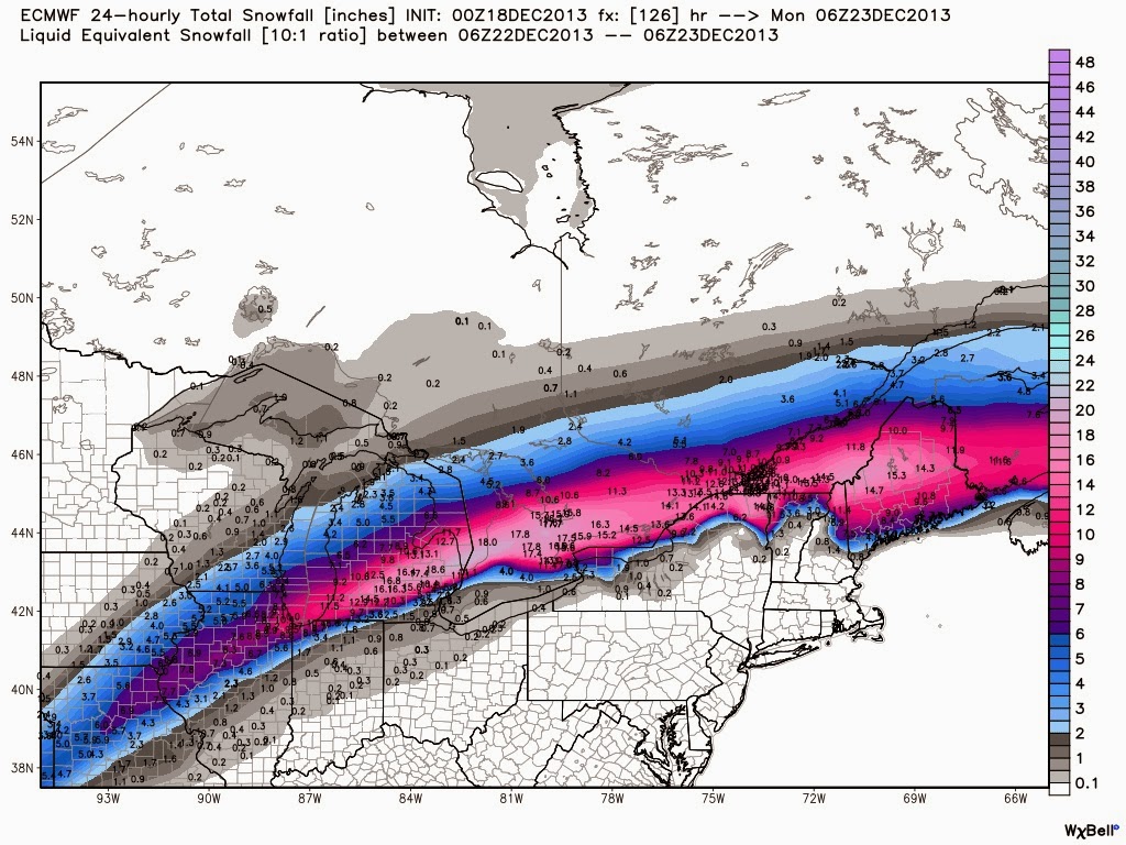
The real deal will be on Sunday, where most models are in agreement about another system passing just south or over the lower Great Lakes.  The Euro (map below) is the most gung-ho about this one and if this comes to pass, there won't be much happening on Sunday, anywhere in southern and eastern Ontario.
The rest of Christmas week looks somewhat colder than normal but not extreme.

24 hr snow total in inches, ending Sunday night.

Saturday, December 14, 2013

Another updated weather map

It's just keeps getting better or worse.  However, this map is a little light in the west of Lake Ontario area as easterly winds are adding Lake Effect snow to the totals.  We have cancelled our road trip plans this weekend.

Friday, December 13, 2013

Updated snow for this weekend, and beyond...

Current trend in the models is throwing more moisture north hence the increased amounts:
Snow is expected to start in the Ottawa area Saturday afternoon.

Beyond this weekend: next week will gradually warmup due to a system heading through the western Great Lakes on Friday which is making for an ugly couple of days.   Currently it is looking like that system will cause (in the Ottawa area) precipitation to start as snow Thursday night, change over to freezing rain then to rain on Friday.  Then Friday night into Saturday, a strong cold front will pass through which will bring some more snow.   My biggest concern is a flash freeze situation, as it looks like temperatures will drop ~ 25 C in 24 hrs.

As always, stay tuned.

Thursday, December 12, 2013

Wednesday, December 11, 2013

The next while...

Cold for the next while.
Looks like we are only getting a dusting this coming weekend, as in a few cms of snow
Next weekend however, the models are in general agreement that there will a more significant system.   However exact track and timing are under debate...

And now for some perspective... Here is the estimated Lake Effect Snow totals over the next couple days.

Tuesday, December 10, 2013

Just for funsies...

Current GFS model map for Christmas Eve:
Which means this kind of precip:
 

The snow we're getting right now...

Are snow squalls originating from Georgian bay...
Fortunately (or unfortunately depending on your nature) these won't last long.   Looks like these will be done in an hour or so.   Just imagine if this lasted for hours as will happen for those in the lee of the lakes...

Monday, December 9, 2013

today...and beyond

Here is another example of Env. Can. publishing forecasts based purely on their model output and NOTHING else.  

Leading up to today's snow, Env. Can. was calling for a high temperature of plus 2C and a change over to rain before the cold front came through.   No other model that I see was calling for this change over.

Today's Env. Can.'s 5 AM and 11AM forecast continued in that vein.   However, I have just noticed a special release forecast (@12:07PM) that now has the high temp at 0C and no changeover to rain.   It's like someone just noticed that the temperatures weren't going up very much and stuck their head out the window and noticed it was still snowing.

Overnight lows not cold enough later this week in Env. Can.  We will be getting close to -20C at least on Thursday.

Next impact snow may be this weekend... Stay tuned

Sunday, December 8, 2013

Tomorrow's snow

Looking like about 2" (5cm-ish) of snow tomorrow.   There may be a bit of freezing drizzle but I don't think it'll change to outright rain like Env. Can. is showing.

Friday, December 6, 2013

The next week or so...

Yes, I've got posting back during the daytime... We'll see how long for.  Anyway, a quick one.
Getting colder over the weekend.
5-10 cm of snow on Monday.
Getting much colder midweek.
Potential for another system next weekend... stay tuned for that.

Wednesday, December 4, 2013

Accuweather has capitulated

and updated their December temperature forecast:

Score a half point for Weatherbell and my man Bastardi.  Next 1/2 point will how close the forecast will be to reality.

Monday, December 2, 2013

Bone chillin' cold...

But not here...  This week we are mild for us.  However, the western half of the country is going to experience some bone chilling cold over the next two weeks at least.   Some of it spills east this weekend and beyond but not nearly to the scope of what is happening in the prairies.   Alberta is currently getting hit with a blizzard which will be followed up with a true Arctic air mass with temperatures hitting close to 20 degrees below normal.  Putting that into real temps, that means most of prairies won't be getting any warmer than -20C for quite a few days...

Our next opportunity for significant snow looks to be next Monday.

Stay tuned.

Canadian and CFS December temp forecasts


Sunday, December 1, 2013

December temperature forecasts..

I subscribe to two private weather information services based out of the US, Accuweather and WeatherBell.  One of Weatherbell founders, Joe Bastardi was senior long range forecaster at Accuweather.   Which is interesting because their respective December temperature forecasts are quite different.

Earlier in November I had posted Weatherbell's forecast.  They've updated it, and it's even colder:


Here is Accuweather.


Interesting battle shaping up..