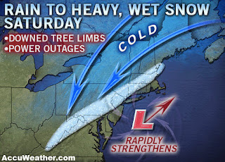
For what it's worth (and it ain't much), the GFS model is predicting a big storm around the middle of the month:
Monday, October 31, 2011
Thursday, October 27, 2011
Wednesday, October 26, 2011
Monday, October 24, 2011
This week (Oct24th)
After a cold front comes through this afternoon, the rest of the week will average cooler than normal. However it looks like the wet and white precip will stay mostly south and east of us. Arghh, visions of last winter!!
Friday, October 21, 2011
Berkeley Earth Surface Temperature
You may have seen the results of the PR campaign from a group from Berkeley who has analyzed and compiled land surface temperatures (no SST info yet) into a new data set with improved statistical methods than the current major indicies, NOAA, GISS, HADCRUT. Some highlights:
Causal issues are not addressed, at least skirted in the decadal cycles portion. The study authors emphasize that causes for the measured land warming is not the issue dealt with in these studies. Some blog entries on this with the first couple from co-authors of the studies.
http://online.wsj.com/article/SB10001424052970204422404576594872796327348.html#printMode
http://judithcurry.com/2011/10/20/berkeley-surface-temperatures-released/
http://dotearth.blogs.nytimes.com/2011/10/20/skeptic-talking-point-melts-away-as-an-inconvenient-physicist-confirms-warming/
http://wattsupwiththat.com/category/berkeley-earth-surface-temperature/
http://www.bishop-hill.net/blog/2011/10/21/keenans-response-to-the-best-paper.html
http://calderup.wordpress.com/2011/10/20/the-long-pause-in-warming-confirmed/
http://pielkeclimatesci.wordpress.com/2011/10/20/comment-on-the-article-in-the-economist-on-rich-mullers-data-analysis/
http://wmbriggs.com/blog/?p=4525
I will provide updates when required.
Update1: Back in the day when I had time, I played with some numbers and came to a similar conclusion as the Berkeley group regarding the decadal oceanic cycles.
- Close agreement with other major datasets
- UHI has minimal effect on final value of GMST, but local effects remain
- There are surface station quality issues but 30% of land surface stations show long term cooling trends
- There are significant co-relations with oceanic decadal cycles
Causal issues are not addressed, at least skirted in the decadal cycles portion. The study authors emphasize that causes for the measured land warming is not the issue dealt with in these studies. Some blog entries on this with the first couple from co-authors of the studies.
http://online.wsj.com/article/SB10001424052970204422404576594872796327348.html#printMode
http://judithcurry.com/2011/10/20/berkeley-surface-temperatures-released/
http://dotearth.blogs.nytimes.com/2011/10/20/skeptic-talking-point-melts-away-as-an-inconvenient-physicist-confirms-warming/
http://wattsupwiththat.com/category/berkeley-earth-surface-temperature/
http://www.bishop-hill.net/blog/2011/10/21/keenans-response-to-the-best-paper.html
http://calderup.wordpress.com/2011/10/20/the-long-pause-in-warming-confirmed/
http://pielkeclimatesci.wordpress.com/2011/10/20/comment-on-the-article-in-the-economist-on-rich-mullers-data-analysis/
http://wmbriggs.com/blog/?p=4525
I will provide updates when required.
Update1: Back in the day when I had time, I played with some numbers and came to a similar conclusion as the Berkeley group regarding the decadal oceanic cycles.
Labels:
AGW,
BEST,
Climate Change,
Curry,
Global Warming,
Muller,
Watts
Thursday, October 20, 2011
Late next week.
Two of the more reliable longer range models are diverging on the solution for late next. I will show a map of the one that shows the most snow. :)
IPCC Exposed
Get your copy today! :)
http://nofrakkingconsensus.com/2011/10/13/a-book-is-born/
Some reactions:
http://judithcurry.com/2011/10/19/laframboise-on-the-ipcc/
http://climateaudit.org/2011/10/16/the-spoiled-child/
http://wattsupwiththat.com/2011/10/14/donna-laframboises-new-expose-book-on-the-ipcc/
http://wattsupwiththat.com/2011/10/16/donna-laframboises-new-book-causing-reviews-in-absentia-amongst-some-agw-advocates/
Wednesday, October 19, 2011
The remainder of this week and next
While Ottawa won't get as much rain out of this system as southern Ontario, the weather is going to be miserable over the next couple days.
Next week won't be much better. A weak clipper will bring light rain Monday. A southern branch storm will bring the possibility of rain Thursday. However the bigger story is the trough and colder air that will come in behind this second system. This will set up the coldest period so far of this fall with snow showers likely, even potentially LES for next Friday and Saturday.
Next week won't be much better. A weak clipper will bring light rain Monday. A southern branch storm will bring the possibility of rain Thursday. However the bigger story is the trough and colder air that will come in behind this second system. This will set up the coldest period so far of this fall with snow showers likely, even potentially LES for next Friday and Saturday.
Monday, October 17, 2011
This week
First of all, the models have converged to a solution which pretty much eliminates the chance for snow in the Ottawa area later this week. The system coming from the south will come up west of the Appalachian mountains. As such, Ottawa will be on the NW side of the storm as it comes up and will entrain "warm" Atlantic air.
That being said, it will not be a nice week with rain, wind and temperatures at most in the low teens for high and falling by weeks end. Saturday may be the nicest day of the week but cool.
The snow may have to wait for next week.
That being said, it will not be a nice week with rain, wind and temperatures at most in the low teens for high and falling by weeks end. Saturday may be the nicest day of the week but cool.
The snow may have to wait for next week.
Friday, October 14, 2011
Next week temps
My feeling is that Env. Canada's forecast temperatures for Ottawa are too high. Other models suggest that temps will struggle to get out of the single digits with overnight lows being in the low single digits for most of the week. However, Env. Canada's official Ottawa temps are measured at the airport and we know how well they reflect reality.
Thursday, October 13, 2011
Snow still on the table for Thursday
The longer range models have been ditty-bopping this system around but it's still there and so is the potential for some wet snow.
Wednesday, October 12, 2011
Tuesday, October 11, 2011
Ugly weekend coming up and beyond
The rain will start Thursday as the remnants of a tropical system (that didn't get named) merges with a frontal system. It will get progressively cooler such that we may see flurries in the air by early Sunday. But the scarier picture is for next Thursday, the 20th...I'll let the picture say the words:
Wednesday, October 5, 2011
Monday, October 3, 2011
Subscribe to:
Comments (Atom)


