TWN is no longer innocuous. Obviously following the Euro model in the development of their forecast, TWN is now predicting a significant snow event this weekend. Below is the Euro snow map. The Canadian has gone to some weird solution that isn't reflected in their issued forecast. So Env. Can. forecast is still not indicative of possible snow amounts.
Tuesday, December 30, 2014

Monday, December 29, 2014
Late Monday post: Winter is coming...again
Don't be fooled by the innocuous forecasts from Env. Can. and TWN. Sunday may have quite a snow event. The models have aligned in an unusual manner. The GFS and Canadian have a system passing over the lower Great Lakes late Saturday into Sunday, giving the estimated snow amounts in the maps below. The Euro and Japanese models however have the system shunted well to the south, not affecting Ontario with any significant snow amounts. Stayed tuned for further updates.


Colder than normal temperatures will last at least two weeks:
Week 1:
 Week 2:

Colder than normal temperatures will last at least two weeks:
Week 1:
Friday, December 26, 2014

Boxing Day post....
So the Christmas storm was rain for most everybody in southern and eastern Ontario, providing a green Christmas day for much of the area...bummer dude.
Anyway, there will be a turn to cold after this Sunday's sloppy mix of precipitation. The next weather of significance looks to be next weekend. However, there is model disagreement on path. The Canadian and GFS are in the same camp, bringing the storm south of us giving us a glancing blow of snow. The Euro has it going through the central lakes, giving us a rain/snow mix with the main precip to our north and west.
Stay tuned.
Thursday, December 18, 2014
Christmas storm
The situation developing for next week is complex and evolving. There are three pieces of energy that may or may not coalesce into a powerful storm for the Great Lakes and NE regions giving rain, freezing rain, snow or a combination of the three. So the models are still figuring out what, where, and how much. Fact remains that something of significance is occurring the middle of next week. I would strongly recommend that you avoid making significant travel plans for Christmas Eve and Day.
Tuesday, December 16, 2014
Christmas Eve storm of 2014...
Starting to get moderately excited about a system that's appearing on all the midrange models. What the Euro is showing is the same as if I drew the maps. You get the picture.
Stay tuned.
Stay tuned.
Holiday season outlook...
Another quick post.
By the look of the models, the period starting about Christmas eve will be much more active weather wise with more frequent storms affecting the southern and eastern Ontario regions.
I hope to post regularly during that period.
Sunday, December 14, 2014
A quick Sunday post.
Divergence on the models for this week.
The Euro is still banging the snow drum for us on Wednesday, keeping enough cold air and moisture around to give us a few inches worth. Also appearing on the model is a major winter storm for the east coast again on next weekend, not affecting Ontario at this time.
The GFS has increased its snow amount for Wednesday and has a very minor system for the week, kinda "meh".
The Canadian has not much snow at all on Wednesday and absolutely nothing for the weekend.
Stayed tuned.
Saturday, December 13, 2014
Another quick Saturday post
Mild until mid next week. The Euro is more vigorous with the snow next Tuesday night, giving us several inches. Most other models are giving us a mixed bag of precipitation as they are bringing the system farther north through the central lakes.
Stay tuned.
Stay tuned.
Tuesday, December 9, 2014
Timing of the snow
While we may get a few cms between now and tomorrow afternoon, I believe the bulk of the snow will come between Wednesday afternoon and Thursday morning.
Monday, December 8, 2014
First snow day of the season?
While the models are all over the place with respect to snow amounts, it is generally looking like a 10 - 15 cm event, mostly falling Wednesday, overnight Wednesday into Thursday. Worse case amounts are in the order of 25 cms.
If there is a snow day, I think Thursday will be it.
If there is a snow day, I think Thursday will be it.
Sunday, December 7, 2014
Turning into a bigger event...
The east coast storm is getting more vigorous on the models. Total snow over the next 6 days from the Euro, GFS and Can.


Friday, December 5, 2014
Next week.
There will be a coastal nor'easter next week. All models agree with that. However in the last few model runs, they've been playing around with the track and intensity such that the some precipitation may come our way, perhaps Tuesday or another day, perhaps a dusting or a few cms. Stay tuned.
Thursday, December 4, 2014
Boring weather
There is nothing exciting on the horizon with respect to the weather. Dribs and drabs of precipitation and around normal temperatures. However, mid month we are looking at a period of above normal temperatures lasting at least a few days, stretching perhaps to Christmas week. That does put in jeopardy a white Christmas, though the odds still quite high for a white Christmas.
Definitely a different December than last year. But beware January.
Definitely a different December than last year. But beware January.
Tuesday, December 2, 2014
Tonight and tomorrow
I have a hard time believing that there will a change over to rain tomorrow, given what I see in the modeling. It's still colder than what they forecasted for this point (4PM Tues). If that continues, I don't see it happening.
Saturday, November 29, 2014
Quick post before supper...
Warming up tomorrow(Sunday) with some showers.
Cooling off Monday
Very cold Tuesday morning, possibly < -15C
Likely more snow than rain on Wednesday.
Cold again Friday morning
Beyond that the models diverge significantly...
Cooling off Monday
Very cold Tuesday morning, possibly < -15C
Likely more snow than rain on Wednesday.
Cold again Friday morning
Beyond that the models diverge significantly...
Monday, November 24, 2014

Cold returning briefly, big snow on east coast
Tonight into tomorrow the temperature will fall such that it will be below zero by tomorrow evening. A big storm will come up the east coast just in time for the American Thanksgiving.
Beyond that we look to be in a transitory pattern, ditty bopping around normal temps.
On a different note, are there other kids very disappointed with the melted snow or is it just mine?
Beyond that we look to be in a transitory pattern, ditty bopping around normal temps.
On a different note, are there other kids very disappointed with the melted snow or is it just mine?
Tuesday, November 18, 2014
We will lose most of the snow on the ground
A weak clipper will come through Wednesday night into Thursday.
We will have a mild few days along with some rain early next week which will take out most of the snow on the ground. But the last few days of the month look colder than normal.
We will have a mild few days along with some rain early next week which will take out most of the snow on the ground. But the last few days of the month look colder than normal.
Sunday, November 16, 2014
First accumulating snow of season and more LES
Our first significant snow of the season and more Lake Effect Snow...
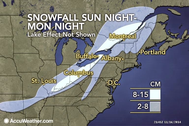

Snow forecast
Models have come around to the Euro idea. Here is the NAM model for total snow over the next 36 hours.

Wednesday, November 12, 2014
Euro still banging snow drum
The latest Euro has this for 24 hr snowfall ending Monday night. The other models are less enthusiastic. Something to keep watch on.


The cold is coming and some snow...
Our bit of rain this morning was the cold front passing through. Temperatures are going to drop through the day today, reaching negative values by this evening. West of us, Peterborough has dropped 10 degrees over the last nine hours to current temp of +3C. Bancroft has dropped 6 degrees over the last six hours to current temp of +2C. Petawawa has dropped 5 degrees in the last 4 hours to current +4C.
Looking forward, this cold will last at least two weeks, relative to normals. Wrt to snow, there is some consensus that Sunday will bring flurries with some light accumulation. The Euro is currently the most enthusiastic with giving us additional cms of snow on Monday.
With this strong Northwesterly flow, the typical areas for Lake Effect Snow are going to get hammered. Snow will be measured in feet in these areas over the next few days.
Monday, November 10, 2014

Sunday, November 9, 2014

Friday, November 7, 2014
Colder and colder...snowier and snowier..
The temperature anomalies of the next two weeks.


And Remembrance Day may be memorable for the wrong reason...

And Remembrance Day may be memorable for the wrong reason...
Thursday, November 6, 2014

Monday, November 3, 2014
This week and this month...
Another chance for snow this Friday/Friday night after a milder than normal week..
However, the middle third of the month looks to be colder than normal with the associated chances for snow.

The last third of the month isn't looking so hot (ha!) either...
You've been warned..winter is coming.
However, the middle third of the month looks to be colder than normal with the associated chances for snow.
The last third of the month isn't looking so hot (ha!) either...
You've been warned..winter is coming.
Friday, October 31, 2014
Where the snow is going...
Here are the maps of the Euro and GFS with their respective prediction of total snowfall over the next 72hrs. Algonquin, Appalachians and New England/New Brunswick are getting hit. Like I wrote the other day, don't be surprised if we get a coating over night tonight.


Wednesday, October 29, 2014
Not as bad as it could have been...
The trough coming in is stronger the predicted earlier. Hence much of the energy is going south of us. So the Eastern Ontario area will get a mix of shower and flurries. Grassy areas may be white Saturday morning in the Ottawa area..
Look for a significant Lake Effect snow event in the typical snow belt regions on the back side of this storm...
Look for a significant Lake Effect snow event in the typical snow belt regions on the back side of this storm...
Sunday, October 26, 2014
Still there....
GFS for Friday evening:

Euro (showing 24hr snowfall from Friday aft to Saturday aft)
 Canadian shows nothing.

Euro (showing 24hr snowfall from Friday aft to Saturday aft)
Saturday, October 25, 2014
A scary Halloween??
Two of the more reliable models are still calling for some downright messy weather late next week as the remnants of Pacific hurricane Ana pass through. The GFS is showing us cold but scattered flurries at this point. The Euro is definitely messier of the two, with several cms of snow predicted by to on Friday and again on Monday.
Snow or no, definitely looking like a cold end of the week into the weekend.
Snow or no, definitely looking like a cold end of the week into the weekend.
Thursday, October 23, 2014

Thursday, October 16, 2014
Recent warm weather...
Before anybody starts claiming climate change, here are the record highs:
Oct. 13: 26.3C in 1995 (2014: 17.1C)
Oct. 14: 24.4C in 1956 (2014: 26.0C, a new record)
Oct. 15: 25.6C in 1956 (2014: 23.5C)
Oct. 16: 26.7C in 1947 (!) (I doubt we are getting anywhere close to that high today)
Oct. 17: 26.7C in 1947(another one!)
Oct. 18: 26.1C in 1947
Apparently October 1956 and 1947 were warm ones in Ottawa...
Wednesday, October 15, 2014
Hurricane Hazel...
As Gonzalo is now a Cat3 hurricane and will likely impact Bermuda as such on Friday, it is good to remember historical hurricanes. Today is the anniversary of the landfall of Hurricane Hazel in 1954 as a Cat4, an unprecedented and as yet unrepeated event for Southern Ontario as it maintained much of its strength coming northward causing vast amounts of damage.
Sunday, October 12, 2014

Wednesday, October 8, 2014

Flakes in the air
There is a chance that, if there is precipitation first thing Thursday morning, it may be of the frozen kind. Temperatures 5000ft up will be cold enough for snow but nothing will stick as surface temps will still be a few degrees above 0.
Wednesday, September 24, 2014

A balanced climate change article
http://business.financialpost.com/2014/09/22/judith-curry-an-unsettled-climate-for-climate-summit/
From one of my favourite climatologists who, a decade ago, was touting the hurricane/climate change link as co-author of a couple papers on the issue. However throughout the past decade, through discussions on her blog, her position has moderated drastically, acknowledging that models are not matching real data and there is far too much uncertainty to make economic policies that would be detrimental.
Here is an article profiling JC.
Monday, September 22, 2014
Summer's last hurrah...
Despite the Autumn equinox occurring tonight, we have a gorgeous week coming up, likely lasting through the weekend.
Take advantage.
Take advantage.
Tuesday, September 9, 2014
Brief look at upcoming weather...
Generally cooler than normal for the next 6-10 days.
The storm that brought snow to Alberta will affect us in Ontario with a bunch of rain late Wednesday into Thursday.
There will be another front coming through late Saturday that will give us more rain. Then some more rain on Tuesday...
I've read articles that this fall will have fabulous colours in our area...
Monday, September 8, 2014

Wednesday, September 3, 2014
Winter is coming...
Okay, so maybe I'm poking the bear a bit, but...

Accumulated snowfall over the next week in Canada (according to the Euro):

Accumulated snowfall over the next week in Canada (according to the Euro):
Monday, September 1, 2014
Brief look..
After a couple weak frontal boundaries bring some precip Tuesday and Friday, it looks like a nice weekend coming up.
Saturday, August 30, 2014
And we wonder why our energy bills are so high...
http://wattsupwiththat.com/2014/08/30/renewable-energy-in-perspective-solar-and-wind-power/
Unfortunately Ontario has similar issues, hence our power bill...
http://www.ieso.ca/Pages/Power-Data/Supply.aspx
Unfortunately Ontario has similar issues, hence our power bill...
http://www.ieso.ca/Pages/Power-Data/Supply.aspx
Thursday, August 28, 2014

Sea Ice update...
We are a couple weeks from the Arctic sea ice minimum. I thought I'd give an update of where global sea ice is at.
Starting with the Antarctic: still well above normal

The Arctic Sea ice is approaching this year's minimum. As of now it looks like it'll be pretty close to last years minimum, which was in the middle of the pack of the last dozen. Meaning there is no Arctic Ice death spiral.

If we looks an the anomaly graph, we can also that the ice has stabilized. The extreme minimum of 2012 caused by a strong Arctic storm, has stopped the wild gyrations as we can see in this graph.

The NW passage also won't be open this year as the channels are jammed with old or new thick ice.

Saturday, August 16, 2014
Tuesday, August 12, 2014
Fun fact about August 12th...
Temperature records in Ottawa for this date:
Lowest Temperature (1939-2011) 6.7°C 1946
Highest Temperature (1939-2011) 35.0°C 1947
Lowest Temperature (1939-2011) 6.7°C 1946
Highest Temperature (1939-2011) 35.0°C 1947

Monday, August 11, 2014
How's our summer been so far...
Based on a conversation I had this past weekend, I decided to look into it. For Ottawa (@Ottawa Airport).
June:
Normal Average High Temp: 24.1C
2014 June Average High Temp: 25.2 C
Normal Average Low Temp: 12.9 C
2014 June Average Low Temp: 13.0 C
Normal Mean Temperature: 18.5 C
2014 June Mean Temperature: 19.2 C
Normal Rainfall: 92.8 mm
2014 June Rainfall: 131.0 mm
Conclusion: June was warmer than normal (largely driven by heatwave ending the month) and wetter than normal (driven by a three day event, 11th thru 13th, totalling more than 48 mms).
July
Normal Average High Temp: 26.5C
2014 July Average High Temp: 25.5 C
Normal Average Low Temp: 15.5 C
2014 July Average Low Temp: 13.9 C
Normal Mean Temperature: 21.0 C
2014 July Mean Temperature: 19.7 C
Normal Rainfall: 91.9 mm
2014 July Rainfall: 109.0 mm (with one day with "missing" data)
Conclusion: July was cooler than normal (only two 30+ C days) and wetter than normal (driven by three 20+ mm daily rainfall totals).
August (so far):
Normal Average High Temp: 25.3C
2014 August (to 10th) Average High Temp: 27.4 C
Normal Average Low Temp: 14.3 C
2014 August (to 10th) Average Low Temp: 13.4 C
Normal Mean Temperature: 19.8 C
2014 August (to 10th) Mean Temperature: 20.4 C
Normal Rainfall: 85.5 mm
2014 August (to 10th) Rainfall: 3.6 mm
Conclusion: we are on track to be average in temperature but dry. However, it is interesting to note we have not have a 30+ C day since July 22nd and the odds of getting more are increasing slim as the normals creep down.
Thursday, August 7, 2014
That's what I'm talking about!
(Source: Env Can.)
Monday, August 4, 2014
Quick post on the week
Actually had some time to look at weather stuff...there was a power outage at work.. Anyway...
The rest of the week looks unsettled but mild with spotty opportunities for t-showers.
Starting Friday and into the first part of next week, the weather is looking great. So if you have outdoor plans this weekend, bravo. If not, make some.
The rest of the week looks unsettled but mild with spotty opportunities for t-showers.
Starting Friday and into the first part of next week, the weather is looking great. So if you have outdoor plans this weekend, bravo. If not, make some.
Monday, July 28, 2014

Tuesday, July 15, 2014
It's been quiet here
With my real job very busy right now with extended hours and otherwise getting ready to go camping, I have no time for my hobby. BUT, in preparation for my vacation next, I did look at the weather for next week up in Algonquin:
Tuesday’s warmer and a higher chance of showers/t-storms.
Wednesday’s scattered showers and getting cooler
Thursday & Friday, clearer but cooler.
But most worrisome: Biting insects are in full force in the region.
Sunday’s okay. Maybe a chance of afternoon showers/t-showers
Monday’s warmer. Also a chance of afternoon showers/t-showersTuesday’s warmer and a higher chance of showers/t-storms.
Wednesday’s scattered showers and getting cooler
Thursday & Friday, clearer but cooler.
But most worrisome: Biting insects are in full force in the region.
Wednesday, July 2, 2014
Update to Chance of showers
It's included in Env. Can. 11 AM forecast:
Today, 2 July: Cloudy with 30 percent chance of showers early this afternoon then a mix of sun and cloud. Wind becoming southwest 20 km/h this afternoon. High 28. UV index 8 or very high.
Chance of showers
Unlike the Env. Can. current forecast (Sunny. Becoming a mix of sun and cloud this morning. Wind becoming southwest 20 km/h late this morning. High 28. UV index 9 or very high.), there is a chance of getting wet this morning.

Monday, June 30, 2014
Quick look at the week
Hot and humid with popcorn thunderstorms today, tomorrow and perhaps into Wednesday. The remainder of the weeks gets cooler but remains unsettled until Friday. The weekend is looking pretty good.
As side note, after a month into the season, the Atlantic tropics are finally popping into action. Eastern North Carolina will likely be hit with what could be a major hurricane("Arthur") this Friday, spoiling 4th of July celebrations for a lot of people.
As side note, after a month into the season, the Atlantic tropics are finally popping into action. Eastern North Carolina will likely be hit with what could be a major hurricane("Arthur") this Friday, spoiling 4th of July celebrations for a lot of people.
Monday, June 23, 2014

Short term debate
US models show tomorrow the bulk of the precipitation tomorrow going north of us. The Euro and Can. model have the bulls-eye right over eastern Ontario.
The Long weekend will start nice but instability will enter into the picture later Sunday. However there is some debate about timing and location.
The Long weekend will start nice but instability will enter into the picture later Sunday. However there is some debate about timing and location.
Friday, June 20, 2014
Oh and welcome to summer
As of 6:51 AM tomorrow morning, the sun will reach its most northern apex. Then the days will start getting shorter....
Pre-weekend post
Weekend weather turning out nice. It's going to gradually warm up. Next significant rain potential is late Tuesday into Wednesday, just like this past week.
Monday, June 16, 2014
Quick look at the week...
First today... showers with possibly some thunder embedded arriving mid afternoon.
Next precipitation is overnight Tuesday into Wednesday.
Cool but clear until the weekend.
Weekend weather is uncertain at this point.
Next precipitation is overnight Tuesday into Wednesday.
Cool but clear until the weekend.
Weekend weather is uncertain at this point.
Friday, June 13, 2014

Tuesday, June 10, 2014
Env. Can. reads my blog*
*probably not.
7:15 AM EDT Tuesday 10 June 2014
Special weather statement in effect for:
Special weather statement in effect for:
- Ottawa North - Kanata - Orléans
- Ottawa South - Richmond - Metcalfe
Significant rainfall possible beginning late Wednesday.
A low pressure system is expected to affect Eastern Ontario beginning later in the day on Wednesday and continuing until Friday. Rain at times heavy and isolated thunderstorms will be associated with this system. The slow moving nature of this system may result in significant rainfall amounts.
At this point, it is still too early to say which locations will be affected the most and how much rain will fall. However, some regions may see amounts in excess of 40 millimetres.
At this point, it is still too early to say which locations will be affected the most and how much rain will fall. However, some regions may see amounts in excess of 40 millimetres.
Monday, June 9, 2014
Quick look at the week
Only rain of significance is late Wednesday into Thursday.
Looks like another beautiful weekend coming up.
Looks like another beautiful weekend coming up.
Friday, June 6, 2014
Texas drought update.
Previous post here. Three maps to show today. The first two maps show the progression of drought status. Compare these with the one in the previous post. The third maps is the predicted rainfall over the next four days. Most of the deep red in Texas and Kansas will be eliminated.


California is still suffering though. That'll change when the El Nino moisture kicks up.
California is still suffering though. That'll change when the El Nino moisture kicks up.

Sunday, June 1, 2014
Another Indonesia volcano
Mt. Sangeang erupted on Friday. While impressive, getting up to 65,000 feet, it ain't a Pinotubo type event and should have minimal climatic impact, provided it doesn't last very long.

Thursday, May 29, 2014

Subscribe to:
Posts (Atom)