Thursday, December 29, 2011
Clippers and cold
There will be a one-two punch of clippers. The first one will mostly pass us to the south and give us a dusting tomorrow. The second on Saturday may be a bit messy with a possible freezing rain and snow. Following this second clipper there will be a brief warm up, where temps will pop above for a half a day before a cold front comes crashing through on Sunday that will bring true Arctic air. Be prepared for a true cold snap for a few days next week, i.e. a few days like today.
Tuesday, December 27, 2011
Baccchh!
As of 9:45 PM, it's raining. There was a promising start with a quick inch of snow in the space of an hour but it then changed over to rain, and hasn't stopped. It'd better change back or I'll make the bellow of the bitterly bummed out.
Monday, December 26, 2011
Tomorrow and the weekend
Looks like the models have shifted west as hoped and we're expecting a thump of snow tomorrow, starting tomorrow morning in southern Ontario and in the afternoon in Ottawa, intensifying as it comes. It will reach peak intensity overnight Tuesday so we will wake up on Wednesday to a nice 6-12" layer of snow. Look for snow amounts on the Env. Can . afternoon forecast (3:30PM) to go up (currently a measly 5cm) as their latest model output has finally shifted the storm west.

For the weekend, there's looks to be a clipper coming through that'll give us another few cms.
Update: 5:30PM Monday. Storm watch from Env. Canada:
Ottawa North - Kanata - Orléans
3:14 PM EST Monday 26 December 2011
Winter storm watch for
Ottawa North - Kanata - Orléans issued
..Potential for heavy wet snowfall in excess of 15 cm during Tuesday night..
A developing low over the southern states will track northeast along the Appalachians Tuesday and intensify as it tracks into Southern Quebec on Tuesday night. In advance of this system, precipitation mainly in the form of light rain, will spread into the watch area Tuesday afternoon. As the low intensifies the rain will change into heavy wet snow during Tuesday evening. Before the snow ends Wednesday morning, total snowfall amounts in excess of 15 cm are possible with the highest amounts expected closer to the Quebec border.
In addition, as the low moves into Quebec a sharp Arctic cold front will cross the area overnight Tuesday into Wednesday morning. The much colder air behind the front means that temperatures will drop sharply from near zero to well below freezing in a matter of hours. While this may result in some slippery surfaces it is unlikely that widespread flash freeze conditions will occur as too much snow will have fallen. Either way, the combination of the snowfall and plummeting temperatures will make for a difficult Wednesday morning commute.
Saturday, December 24, 2011
This Coming week
We'll get a dusting tomorrow afternoon/evening.
All the models are in general agreement about a storm on Tuesday. I think this is a mostly snow event with accumulation of 10 cm or so.
There's also a system next week but some disagreement on the track.
Merry Christmas all.
Update: late Christmas Eve. The latest models have the Tuesday system pushed south and east. Ahhh... Here's hoping for an Westward correction.
Thursday, December 22, 2011
Not much happening.
Yeah, about that Christmas storm, it's not happening. Both the Canadian and the Euro fell off the wagon in yesterday's run. The problem essentially is that storm energy in the northern jet stream isn't phasing (joining) with energy in the southern jet stream to create a bigger/potent storm. So all you're left with is two systems that are a whole lotta nothing, just meh.
And I am not seeing anything of note for a while. We may get a little dusting tomorrow as a meh system passes to the south and another dusting on Sunday from a meh system passing to the north. The Euro is trying to phase something for the New Years weekend but we'll see.
I had a quick look (don't have time for an extensive look) at past years with similar atmospheric and La Nina conditions. I was able to find a year with similar Arctic Oscillation (AO), North Atlantic Oscillation (NAO) and La Nina conditions. And I couldn't find one that was real close. The closest would be the 92/93 and 94/95 winters but they were neutral to El Nino years. Both of those winters had mild starts in the east side of North America to January. Then February was brutally cold. I'm not saying that will happen given the remaining differences but it's a possibility.
Wednesday, December 21, 2011
The ice rain
It started about 11 AM this morning in Bells Corners. There was about a 1/8 to 1/4" accumulated ice as had Barrhaven when I came home. I also heard Stittsville had significant accumulations.
I think it was a good call cancelling school this morning.
I think it was a good call cancelling school this morning.
Welcome to Winter
Astromonically speaking, we will enter the Winter season tonight as the Winter Solstice begins at 12:30 AM. So there is a lot of winter yet so don't despair.
Latest warning
Ottawa North - Kanata - Orléans
4:44 AM EST Wednesday 21 December 2011
Freezing rain warning for
Ottawa North - Kanata - Orléans continued
Freezing rain beginning later this morning.
A low pressure system originating in Texas is forecast to track over Lake Ontario this evening. Precipitation ahead of this low has spread into Southern Ontario and will reach the National Capital Region by noon.
The precipitation will encounter colder air in Eastern Ontario and will likely begin as snow or freezing rain. The precipitation is expected to change over to rain after a few hours over regions near the Kawarthas and Haliburton Highlands. However regions near the Ottawa River could experience an extended period of freezing rain of 6 hours or more.
Freezing rain amounts will likely be in the 5 to 10 millimetre range. The precipitation is expected to taper off in Eastern Ontario late this evening.
Tuesday, December 20, 2011
Woot!
http://trailers.apple.com/trailers/wb/thehobbit/
Update: an non-Quicktime version: http://www.tribute.ca/trailers/the-hobbit-an-unexpected-journey/18488/
Update: an non-Quicktime version: http://www.tribute.ca/trailers/the-hobbit-an-unexpected-journey/18488/
This week again
I waited to post until all the models output their 12Z runs.
First, later tomorrow: it is looking like Env. Can. is right on this one, that'll be a mix of freezing rain and snow. Hopefully more snow than rain that'll stick around.
Weekend storm: the GFS has fallen off the bandwagon for the Christmas storm. However, the Euro is still showing, even strengthening, the storm in the US NE and Maritimes. The Euro is supported by the Canadian (which makes me nervous) and by the Japanese somewhat. If the Euro is correct, then we won't get much of anything in Ottawa. Hopefully it's right about the storm but shifts to the left (of the map) :).
So there is a model war going on between two of the more accurate mid-range models... Let's see who wins.
Monday, December 19, 2011
This week
To date this winter has been so much of a non-winter that even my wife is complaining about the lack of snow. She figured moving to Ottawa was a guarantee to have a white Christmas. Unfortunately there are no guarantees with the weather.
Take the current situation in the SW US. They having a blizzard right now. Whodathunk parts of New Mexico, Texas, Kansas, Oklahoma and Colorado would have tonnes more snow than we? But that's this situation.
Take the current situation in the SW US. They having a blizzard right now. Whodathunk parts of New Mexico, Texas, Kansas, Oklahoma and Colorado would have tonnes more snow than we? But that's this situation.

But we may be able to pull a white Christmas out of the hat. The storm that is currently bashing the SW US will cut to the Great Lakes but weakening as it comes. I think we will get more snow than rain but not much of either. A system has appeared on the models for this weekend (Christmas Eve/Day). The Euro/DGEX have it going south and east of so that NE US and the Maritimes get a good dumping. But the GFS has us getting a piece of the storm Christmas Eve.
To be sure, I'll be watching the each model outputs with baited breath. Most models give two runs per day, some give four.
To be sure, I'll be watching the each model outputs with baited breath. Most models give two runs per day, some give four.
Thursday, December 15, 2011
The Green Police are on the job...
http://tallbloke.wordpress.com/2011/12/14/tallbloke-towers-raided-many-computers-taken/ http://climateaudit.org/2011/12/14/police-raid-on-tall-bloke/
http://noconsensus.wordpress.com/2011/12/14/crackdown-shooting-in-the-dark/
http://bishophill.squarespace.com/blog/2011/12/15/norfolk-vice.html
http://rankexploits.com/musings/2011/tallbloke-the-air-vent-climate-audit/
http://noconsensus.wordpress.com/2011/12/14/crackdown-shooting-in-the-dark/
http://bishophill.squarespace.com/blog/2011/12/15/norfolk-vice.html
http://rankexploits.com/musings/2011/tallbloke-the-air-vent-climate-audit/
Wednesday, December 14, 2011
Next week
It's looking like we'll get some snow next week in batches. The first two systems have fair agreement among the models: a clipper passing to the north on Monday will likely give us some snow showers. A system passing to our south on Wednesday will likely have precipitation that will hit us in the form of snow. This system on Friday/Saturday is under debate. The GFS backed off a Christmas Eve storm (see yesterday's post) but the Euro is now bullish for something fairly significant happening on the Friday.
One thing's fairly certain is that we'll some snow at some point which is more than we can say for this winter so far.
One thing's fairly certain is that we'll some snow at some point which is more than we can say for this winter so far.
Tuesday, December 13, 2011

Monday, December 12, 2011
The result of Durban
Long and short, the agreement they came to was...to agree to talk again and try to come to an agreement by 2015 that comes into effect in 2020 that will have less stringent requirements that Kyoto had.
All I know is, if Greenpeace is unhappy, I am happy.
As an aside, I have a hunch that 2020 date was chosen since are more than a few CAGW skeptical scientists who think we will have a 20 year plus negative trend in Global temperatures by that point, which I hope will be the case. If so, than the natural vs manmade climate change proportion will be up-ed, defying all current Global Climate Models.
Update: Interesting analysis of Durban here.
Friday, December 9, 2011
Can we get some winter please?
The arrival of the cold and snow is continually getting delayed and delayed. In last Friday's post I discussed the NAO and PDO where at that time they were predicted to head towards the neutral and negative state. And yes they've come down from their lofty heights but not as far down as predicted and, unfortunately for cold and snow lovers in our area, they are currently predicted to do a U-turn right back to significate postive levels.
So that piddly little snow we had this week, yeah it's going to go melt this coming week as the models have become less enamoured with a trough in the east over the coming week.
Maybe the following week....
So that piddly little snow we had this week, yeah it's going to go melt this coming week as the models have become less enamoured with a trough in the east over the coming week.
Maybe the following week....
Wednesday, December 7, 2011
Permafrost
Remember when Global Warming was going to melt all the Russian permafrost, releasing tonnes of potent GHG methane into the atmosphere making Global Warming worse, melting more permafrost, etc etc? Well, nevermind.
White Christmas?
My last couple of posts ties into this quite nicely actually. Everybody is looking at the operational models and not the ensembles which are saying two different things.
I see a white Christmas for 99% of Canada. Besides, that is already the case:

I see a white Christmas for 99% of Canada. Besides, that is already the case:

Storms and rumours of storms
Firstly, the disparity between the operation run and ensemble run of the GFS continues today.
However, to the more interesting (;)) stuff... A couple bigger storms have appeared on the horizon.. The first one is next weekend which may lay down a signficant snow:

Then there is another one....for Christmas Eve? Now that would be fun, wouldn't it?
However, to the more interesting (;)) stuff... A couple bigger storms have appeared on the horizon.. The first one is next weekend which may lay down a signficant snow:

Then there is another one....for Christmas Eve? Now that would be fun, wouldn't it?
Tuesday, December 6, 2011
Interesting...
I've been just comparing the 6Z operational run of the GFS model for day 6-10 500 mb height anomolies (essentially where the ridges and troughs lie) with the GFS ensemble (same model, slightly different input parameters) mean for day 6-10 500mb height anomolies and they are the polar opposite:
GFS operational 6Z run:


Canadian Ensemble (Day 8):

GFS operational 6Z run:

GFS Ensemble 6Z run:

The operational run would indicate a warm up for us and the ensemble would indicate cooler weather for us. I am leaning towards the ensemble for two reasons. First the ensemble mean is a better indicator of future trends than a single run of the GFS. Secondly, there is support for the ensemble from other models:
European:

Canadian Ensemble (Day 8):

So I still see support that we won't see any major thaws for a while. Whether snow is included is unknown.
Is that all there is?
That's pretty much what my six year old son said this morning. His actual words were "when are we getting a lot of snow?" Yes, it was somewhat disappointing to see the accumulation amounts this morning. However, they were within predicted amounts, just on the low side. If this system happened just a couple weeks from now, there would have been a LOT more snow. But it wasn't.
So when are we getting a lot of snow? Hmmm...I don't know but I know we miss it regularly:

So when are we getting a lot of snow? Hmmm...I don't know but I know we miss it regularly:

It's turned to snow.
As of midnight, the rain has turned over to snow. It's not sticking yet as the surface temperature is still above 0 C but that'll change in the next hour or two. We should wake up to snow covered ground.
Monday, December 5, 2011
Is this it?
Could tonight's snow be the one that sticks around indefinitely? Could be. I am not seeing any major thaw like temperatures over the next couple weeks. By that time, the "normal" temperatures are low enough that any above normal period will still be below freezing..hopefully. :)
Snow very likely
It's been interesting to watch the Env. Can. forecast go from no mention of snow before yesterday to yesterday's forecast of 2cm of snow for tonight to today's forecast of 2-4+ cms for tonight into tomorrow.
However there is a chance that we could still miss out. The NAM model is keeping most of the snow south of the Ottawa region so that Kemptville would get more than us.
Fingers crossed.
PS. note that my Nov. 28th post made the call for snow.
However there is a chance that we could still miss out. The NAM model is keeping most of the snow south of the Ottawa region so that Kemptville would get more than us.
Fingers crossed.
PS. note that my Nov. 28th post made the call for snow.
Friday, December 2, 2011
When's the cold and snow coming?
Yeah, good question. A couple weeks ago, I would have said now. But things haven't panned out that way. A couple of atmospheric conditions/indexes, the North Atlantic Oscillation (NAO) and the Arctic Oscillation (AO) are stubbornly remaining positive. As a result, very little Arctic air is allowed to remain in the Eastern North America region and no storms of note are coming up the eastern seaboard.
But there is hope. As indicated in the links above, these indices are predicted to approach negative territory in a week or so. So I think the seasonal temperatures will come next week. As for snow, that'll depend on the storm track and the arrival of cold. So it's looking like late Monday/Tuesday where we may get some snow...but not a lot.
For readers from Southern Ontario (I know you're out there) in the typical snow belt regions, look for significant Lake-Effect-Snow events happening late next week.
Wednesday, November 30, 2011
Temperature is going to drop soon
As of 12:50PM Pembroke is down to -1C, Bancroft is down to -2C. We should see our temperatures dropped soon. There are some heavy bands of snow associated with the front so we may see some white on the ground this afternoon.
Cool video of the 2011 Atlantic Tropical storm season
Time lapse video from Satellite images. I found it especially interesting to see how the jet stream can just destroy an established tropical storm.
Tuesday, November 29, 2011
Working out pretty good
Last week Wednesday I posted "The 29/30th may be messy". I'd say that's working out pretty well.
Monday, November 28, 2011
Don't be fooled...and coming snow
By our warmth: the northern hemispheric snow cover is above normal, Russia has it all. :) :

I think our best chance to get a dose of snow will be next Monday as system develops along a front boundery. If enough cold air can be in place, then we could have a dump.
Thursday, November 24, 2011
Changes blowing in the wind
Long range models are indicating that a pattern change/shift is coming where the mean trough position will be more towards the central/eastern portion of the continent rather than the west. This means more "seasonable" temperatures and thereby snow opportunities for a while.
Look for this to happen in early December.
Look for this to happen in early December.
Wednesday, November 23, 2011
It's all going to melt
Unfortunately this isn't the snow that will stick around for the rest of the season. It'll melt over the next few days. The models are all over the place for early next week with cutoff lows and slowing cold fronts, rain and snow. The 29/30th may be messy.
Tuesday, November 22, 2011
Climategate 2.0
Two years ago, on the eve of the Copenhagen climate conference, unknown person(s) released thousands of documents revealing the machinations of the warmist climate scientists. It was dubbed Climategate.
The next climate conference is happening shortly in Durban and it's happened again. Anothe cache of revealing emails and other documents from the warmists have been released. Details here:
http://noconsensus.wordpress.com/2011/11/22/climategate-2-0/
http://climateaudit.org/2011/11/22/new-climategate-emails/
http://tallbloke.wordpress.com/2011/11/22/breaking-news-foia-2011-has-arrived/
http://wattsupwiththat.com/2011/11/22/climategate-2-0/
http://rankexploits.com/musings/2011/son-of-climategate/
Monday, November 21, 2011
Wednesday..
Could be interesting. First off, Env. Can is calling for periods of snow. I initially discounted it last week. The GFS model is still keeping the precip south of us...but its regional counterpart model, the NAM, is having Ottawa catching the northern edge of the precipitation band as is the European model, the ECMWF as well as having it cold enough to snow.
So now I'm in a bit of a waffle situation...but I'm leaning towards Ottawa getting a few centimeters of snow on Wednesday.
So now I'm in a bit of a waffle situation...but I'm leaning towards Ottawa getting a few centimeters of snow on Wednesday.
Saturday, November 19, 2011
Friday, November 18, 2011
Env. Can. jumping the gun
Env. Can. is currently calling for snow on Monday: Periods of snow. Low minus 8. High minus 1.
Ahh...no.
Snow will go by to north tomorrow with a trailing cold front that will bring showers ending in flurries on Sunday. Monday will cool with very little in the way of precip. Snow will pass by to the south on Wednesday.
So no significant snow for us over the next few days.
Ahh...no.
Snow will go by to north tomorrow with a trailing cold front that will bring showers ending in flurries on Sunday. Monday will cool with very little in the way of precip. Snow will pass by to the south on Wednesday.
So no significant snow for us over the next few days.
Extreme weather
You may have seen news articles about an IPCC report regarding extreme weather. Most news articles I've seen put a Catastrophic AGW spin on it, i.e. we're all going drown/bake/die of thirst etc etc etc. However, that isn't really in the report.
First a preface. Extreme weather happens all the time. It has been part of the climate since it was created. Increasing extreme weather only exists in the Global Climate Models (GCMs). Actual observations have not shown any increasing global trends that co-relate with increasing global temperatures. I have shown this for floods, droughts, tropical storms, heat waves, etc.
Here is a couple comments regarding this new report:
http://rogerpielkejr.blogspot.com/2011/11/leaked-text-of-ipcc-extreme-report.html
http://dotearth.blogs.nytimes.com/2011/11/18/climate-panel-issues-report-on-extreme-weather-and-climate-change/
http://www.thegwpf.org/science-news/4369-natural-variability-to-dominate-weather-events-over-coming-20-30-years.html
Thursday, November 17, 2011
Snow shower happening right now
Just looked out a window and saw snow falling. Time to change my profile picture.
Wednesday, November 16, 2011

Monday, November 14, 2011
The short and long terms prospects of cold...
I've had a few comments on how mild our weather has been this fall overall, and whether we're going to pay for it later...
Yes, to date we have had a very moderate fall. Of late, we've had cool periods but they are few and short as pieces of the main pool of cool in the west come our way. Speaking of the west, the regions of Alaska Yukon, down to BC and AB will be getting very cold over the next week as cold air pours in from the Arctic. For example, Fort Nelson will get down to -25C this week (normal is -18), Whitehorse will get down to -27C(normal is -14). A piece of the cool air will come our way this Wednesday through Friday and again next Sunday through Tuesday. But the pattern is transitory, nothing sticking our area for any significant period of time.
Whether we will pay for the mild weather later?...Maybe... I we will see December have a sustained cold period for our area, but don't be surprised that we will get a snowfall before November's end that sticks around until the end of winter. We will have another La Nina winter as was last year. And last year was a disappointing winter for eastern ontario snow geese. So I am expecting not a lot of cold and snow in the latter part of the winter.
Update: a graphical view of the North American temperature anomolies over the next 8 days (source). Note this is a deviation from normal graphic, not actual temperature.

Monday, November 7, 2011
Winter weather
Will have to wait...As expected the storm at the middle of the month is turning more wet than white. We may see some flakes this weekend as a week clipper passes to the north but nothing significant is currently in the cards until later this month.
For Remembrance Day observances, it's looking chilly with possible flakes in the air so bundle up.
For Remembrance Day observances, it's looking chilly with possible flakes in the air so bundle up.
Tuesday, November 1, 2011
Some recommended reading...
In the shorter term...
We will be mild until a cold front (causing showers) comes through on Thursday bringing a brief 2-day cold shot. It looks to be a nice weekend as it will start to warm up again on Saturday (warmer than Env. Can is currently saying: 6 and 7 C for Sat. Sun. respectively) with no precip. Another cold front comes through on Monday.
Currently it looks like next Wednesday and Thursday will have a system coming through but mostly rain, with perhaps snow on the backend of it.
And yes, the storm at midmonth is still on the table:

Currently it looks like next Wednesday and Thursday will have a system coming through but mostly rain, with perhaps snow on the backend of it.
And yes, the storm at midmonth is still on the table:

Monday, October 31, 2011
Just having a bit of fun
For what it's worth (and it ain't much), the GFS model is predicting a big storm around the middle of the month:


Thursday, October 27, 2011

Wednesday, October 26, 2011

Monday, October 24, 2011
This week (Oct24th)
After a cold front comes through this afternoon, the rest of the week will average cooler than normal. However it looks like the wet and white precip will stay mostly south and east of us. Arghh, visions of last winter!!
Friday, October 21, 2011
Berkeley Earth Surface Temperature
You may have seen the results of the PR campaign from a group from Berkeley who has analyzed and compiled land surface temperatures (no SST info yet) into a new data set with improved statistical methods than the current major indicies, NOAA, GISS, HADCRUT. Some highlights:
Causal issues are not addressed, at least skirted in the decadal cycles portion. The study authors emphasize that causes for the measured land warming is not the issue dealt with in these studies. Some blog entries on this with the first couple from co-authors of the studies.
http://online.wsj.com/article/SB10001424052970204422404576594872796327348.html#printMode
http://judithcurry.com/2011/10/20/berkeley-surface-temperatures-released/
http://dotearth.blogs.nytimes.com/2011/10/20/skeptic-talking-point-melts-away-as-an-inconvenient-physicist-confirms-warming/
http://wattsupwiththat.com/category/berkeley-earth-surface-temperature/
http://www.bishop-hill.net/blog/2011/10/21/keenans-response-to-the-best-paper.html
http://calderup.wordpress.com/2011/10/20/the-long-pause-in-warming-confirmed/
http://pielkeclimatesci.wordpress.com/2011/10/20/comment-on-the-article-in-the-economist-on-rich-mullers-data-analysis/
http://wmbriggs.com/blog/?p=4525
I will provide updates when required.
Update1: Back in the day when I had time, I played with some numbers and came to a similar conclusion as the Berkeley group regarding the decadal oceanic cycles.
- Close agreement with other major datasets
- UHI has minimal effect on final value of GMST, but local effects remain
- There are surface station quality issues but 30% of land surface stations show long term cooling trends
- There are significant co-relations with oceanic decadal cycles
Causal issues are not addressed, at least skirted in the decadal cycles portion. The study authors emphasize that causes for the measured land warming is not the issue dealt with in these studies. Some blog entries on this with the first couple from co-authors of the studies.
http://online.wsj.com/article/SB10001424052970204422404576594872796327348.html#printMode
http://judithcurry.com/2011/10/20/berkeley-surface-temperatures-released/
http://dotearth.blogs.nytimes.com/2011/10/20/skeptic-talking-point-melts-away-as-an-inconvenient-physicist-confirms-warming/
http://wattsupwiththat.com/category/berkeley-earth-surface-temperature/
http://www.bishop-hill.net/blog/2011/10/21/keenans-response-to-the-best-paper.html
http://calderup.wordpress.com/2011/10/20/the-long-pause-in-warming-confirmed/
http://pielkeclimatesci.wordpress.com/2011/10/20/comment-on-the-article-in-the-economist-on-rich-mullers-data-analysis/
http://wmbriggs.com/blog/?p=4525
I will provide updates when required.
Update1: Back in the day when I had time, I played with some numbers and came to a similar conclusion as the Berkeley group regarding the decadal oceanic cycles.
Thursday, October 20, 2011
Late next week.
Two of the more reliable longer range models are diverging on the solution for late next. I will show a map of the one that shows the most snow. :)


IPCC Exposed
Get your copy today! :)
http://nofrakkingconsensus.com/2011/10/13/a-book-is-born/
Some reactions:
http://judithcurry.com/2011/10/19/laframboise-on-the-ipcc/
http://climateaudit.org/2011/10/16/the-spoiled-child/
http://wattsupwiththat.com/2011/10/14/donna-laframboises-new-expose-book-on-the-ipcc/
http://wattsupwiththat.com/2011/10/16/donna-laframboises-new-book-causing-reviews-in-absentia-amongst-some-agw-advocates/
Wednesday, October 19, 2011
The remainder of this week and next
While Ottawa won't get as much rain out of this system as southern Ontario, the weather is going to be miserable over the next couple days.
Next week won't be much better. A weak clipper will bring light rain Monday. A southern branch storm will bring the possibility of rain Thursday. However the bigger story is the trough and colder air that will come in behind this second system. This will set up the coldest period so far of this fall with snow showers likely, even potentially LES for next Friday and Saturday.
Next week won't be much better. A weak clipper will bring light rain Monday. A southern branch storm will bring the possibility of rain Thursday. However the bigger story is the trough and colder air that will come in behind this second system. This will set up the coldest period so far of this fall with snow showers likely, even potentially LES for next Friday and Saturday.
Monday, October 17, 2011
This week
First of all, the models have converged to a solution which pretty much eliminates the chance for snow in the Ottawa area later this week. The system coming from the south will come up west of the Appalachian mountains. As such, Ottawa will be on the NW side of the storm as it comes up and will entrain "warm" Atlantic air.
That being said, it will not be a nice week with rain, wind and temperatures at most in the low teens for high and falling by weeks end. Saturday may be the nicest day of the week but cool.
The snow may have to wait for next week.
That being said, it will not be a nice week with rain, wind and temperatures at most in the low teens for high and falling by weeks end. Saturday may be the nicest day of the week but cool.
The snow may have to wait for next week.
Friday, October 14, 2011
Next week temps
My feeling is that Env. Canada's forecast temperatures for Ottawa are too high. Other models suggest that temps will struggle to get out of the single digits with overnight lows being in the low single digits for most of the week. However, Env. Canada's official Ottawa temps are measured at the airport and we know how well they reflect reality.
Thursday, October 13, 2011
Snow still on the table for Thursday
The longer range models have been ditty-bopping this system around but it's still there and so is the potential for some wet snow.
Wednesday, October 12, 2011
Follow up to yesterday's post
Confirmation of what I wrote.
http://www.accuweather.com/blogs/news/story/56249/more-snow-around-great-lakes-a-1.asp
http://www.accuweather.com/blogs/news/story/56249/more-snow-around-great-lakes-a-1.asp
Tuesday, October 11, 2011
Ugly weekend coming up and beyond
The rain will start Thursday as the remnants of a tropical system (that didn't get named) merges with a frontal system. It will get progressively cooler such that we may see flurries in the air by early Sunday. But the scarier picture is for next Thursday, the 20th...I'll let the picture say the words:


Wednesday, October 5, 2011


Monday, October 3, 2011
Tuesday, September 27, 2011

Friday, September 23, 2011
Happy Autumn
We're into Fall as we enjoy some North American indigenous peoples summer weather. The North pole won't see the sun for 175 days.
Wednesday, September 21, 2011
Almost Fall
The Autumn Equinox happens at 5:04 AM this Friday, September 23rd. Snow covers a good chunk of the Canadian Arctic Archipeligo. The Arctic sea ice reached its minimum a week ago, second lowest in the satellite era (but not lowest in paleoclimatological record, discussed here) despite the very late start of the Eastern Canadian/Western Greenland freeze season due to a prolonged period of a strong negative AO atmospheric circulation (discussed here) which undoubtedly affected the melt season.
Tuesday, September 20, 2011
"Missing Heat"
I just had to laugh. You may have seen news articles proclaiming a new study that the "missing heat" may have been found in the deeeeeep ocean where there are very few measurements.
This study comes from Kevin Trenbeth, a man whose name was all over the Climategate files, blocking papers, forcing journal editors to resign, redefining peer-review and all kinds of other mischief. But perhaps his most famous quote of Climategate was "The fact is that we can't account for the lack of warming at the moment and it is a travesty that we can't."
The lack of warming is the fact that global atmospheric temperatures have been flat for the last 10 years. The upper ocean heat content (0 - 700m) has been flat since 2003. So the warmists have this theory that all this CO2 in the air has to force atmospheric and oceanic temperatures up and up and up and natural cycles be damned. However, those darned observations are not agreeing with theory so the observations are inadequate. Another Climategate Trenbeth quote: "but the data are surely wrong. Our observing system is inadequate."
So to reconcile the difference between theory and observations, the heat must be where we can't observe it, in the deep ocean. That is discounting the reality that there is no physical mechanism where the upper ocean heat content can remain flat while the deep ocean increases in heat content for that length of time. It's physically impossible. But that doesn't necessarily stop the warmists from outputting garbage from a computer model. Pielke Sr. has a discussion here.
Saturday, September 17, 2011
Frost in outlying areas this morning
Bancroft got down to -2C
Kemptville got down to OC
Petawawa got down to -1C
Gatineau got down to 0C.
Ottawa Airport? 4 C. At least 4 C higher than anywhere else. Urban Heat Island anyone?
Kemptville got down to OC
Petawawa got down to -1C
Gatineau got down to 0C.
Ottawa Airport? 4 C. At least 4 C higher than anywhere else. Urban Heat Island anyone?
Monday, September 12, 2011
First frost?
Frost may be coming to our region the last few days of this week. Watch for Env. Canada's forecast low temps get lower as the week progresses. They are currently predicting 11, 4 and 5 C for Thursday thru Saturday respectively.
Wednesday, August 31, 2011

Accumulations from Irene
US NE:
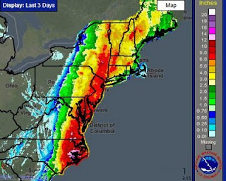


Canadian (7 day accumulation Aug 23rd to 29th)

As you can see the biggest threat from Irene was/is flooding.
Tuesday, August 30, 2011
Unseasonbly mild the remainder of week
Update: Afternoon forecast from Env. Can. is now with the program and has showers on Thursday
Until a cold front comes through on Saturday. There is the potential for unsettled-ness, i.e. showers on Thursday.
Until a cold front comes through on Saturday. There is the potential for unsettled-ness, i.e. showers on Thursday.
Monday, August 29, 2011
Welcome to my new blog
I haven't been happy with Xanga for a while. It wasn't reliable in it's performance and was awkward to change appearance. So I've moved. The biggest change will be in the sidebar where there is local weather and time as well as most of the links in my "Favourites" menu. Feel free to explore the links, that's why they're there.
Subscribe to:
Comments (Atom)