Cold start to January.
A few cms of snow Thursday from a clipper.
Meh weather next week with nothing of significance until maybe the end of the week.
Monday, December 31, 2012
Thursday, December 27, 2012
Beautiful snow...
By the looks of it, as of 8:30 AM, looks like about 15-20 cms has fallen so far (it's up to my dog's back), with it snowing to beat the band and radar showing it'll last a good part of the day.
A good day to be snowed in.
A good day to be snowed in.
Wednesday, December 26, 2012
Updated map and snow storm warning
 |
| From Accuweather |
Env. Can has issued Winter Storm warning for areas near the Lower Great Lakes and the St. Lawrence seaway. For example, Brockville:
Brockville - Prescott
1:14 PM EST Wednesday 26 December 2012
Winter storm warning for
Brockville - Prescott continued
Snow and blowing snow beginning over the Niagara Peninsula this afternoon and over Eastern Ontario this evening.
An intensifying winter storm centred over Kentucky will track well south of the Lower Great Lakes today. It will be accompanied by a large area of snow.
Over the Niagara and Dunnville areas snow will begin this afternoon. Snow will fall heavy at times this evening into the overnight hours before tapering off Thursday morning. Total snowfall amounts are expected to be in the 15 to 20 cm range with local 25 possible. The falling snow combined with northeast winds gusting to 60 or 70 km/h will create considerable blowing snow with reduced visibilities frequently less than 500 metres.
Over Eastern Ontario snow will begin this evening. Snow will fall heavy at times overnight into Thursday morning before tapering off Thursday afternoon. Total snowfall amounts are expected to be 15 to locally 20 cm. The falling snow combined with northeast winds gusting to 50 km/h will create blowing snow with reduced visibilities less than 500 metres at times.
This is a significant winter storm due to the combination of heavy snow and blowing snow. Travellers should allow considerable extra time and exercise caution if required to drive later today, tonight and Thursday.
Tuesday, December 25, 2012
SWS from Env. Can.
Potential winter storm boxing day into Thursday.
---------------------------------------------------------------------
==discussion==
A low pressure system is currently intensifying over Texas and is forecast to track northeastward to pass south of the Great Lakes region late Wednesday into Thursday. Such a storm track would place
Southern Ontario on the cold side of the storm, with the potential for significant snowfall accumulations.
Present indications suggest that the snow will start over the southwest Wednesday morning, and then spread eastward to reach Eastern Ontario late in the evening. In addition, gusty northeast winds would result in local blowing snow reducing visibilities. Conditions should improve from west to east on Thursday.
Current indications suggest that areas from Windsor to Niagara and Hamilton, as well as along the St Lawrence Valley, will see the highest total snow amounts with 10 to 15 cm likely. Snowfall Warnings may be required if the warning criteria of 15 cm in 12 Hours is exceeded.
Further north from Sarnia to Toronto to Ottawa snowfall amounts will probably be in the 5 to locally 10 cm range. (YFNWG: I think it will be 10-15 range)
The exact track of the low will determine the snowfall amounts in each location. If the low tracks further to the south, snowfall amounts will be less, and the if the low track further to the north,
snowfall amounts will be higher. The track of the storm will become more certain as the event draws closer.
The public is advised to monitor future forecasts and warnings as warnings may be required or extended.
Please monitor the latest forecasts and warnings from Environment Canada at www.weatheroffice.gc.ca
END/OSPC
Monday, December 24, 2012

Sunday, December 23, 2012
Quick post from down south
Areas that missed snow accumulations with Friday's storm will get theirs this week. There is a weak system passing to the south of the lakes Christmas that will bring a couple cms or so to southern Ont. Ottawa will get nothing from this one. The second system will follow a slightly more southerly track than last Friday's storm (official storm totals are still TBD on that one), starting Boxing day in SW Ontario and hitting the Ottawa Area on the 27th. Therefore this will likely be an all snow storm for much of Ontario with higher amounts in southern Ontario. Ottawa will get about 5-15 cms with this one.
Thursday, December 20, 2012
Latest Env. Can. warning
Ottawa North - Kanata - Orléans
11:07 AM EST Thursday 20 December 2012
Snowfall warning for
Ottawa North - Kanata - Orléans continued
Heavy snow expected tonight and Friday.
A Colorado low is tracking northeast towards lower Michigan and is intensifying into a winter storm as expected. Snow ahead of this storm will arrive over areas near Georgian Bay later this afternoon then quickly spread eastward into the Ottawa and St Lawrence valleys this evening.
The snow will quickly become heavy at times this evening and continue tonight and through Friday with total snowfall amounts of 15 to 25 cm expected across the district by Friday evening. Over Eastern Ontario snowfall rates up to 5 cm per hour will be quite possible during the height of this snowstorm, which is expected to be overnight into Friday morning. Total snowfall amounts could be a bit less in the St Lawrence Valley due to the possibility of mixing with some rain on Friday.
Brisk easterly winds will also cause low visibility at times in blowing snow.
As the Colorado low tracks east across Southern Ontario into New York State, it is expected to get absorbed by an East Coast low which is forecast to intensify and track northward towards Southeastern Quebec by Friday night. If this happens, heavy snow may persist in the Renfrew through Ottawa to Cornwall areas into Friday night, with potential for higher total snowfall amounts of 30 cm.
Motorists should be prepared for hazardous winter driving conditions tonight and Friday and adjust travel plans accordingly.
The snow will taper off from west to east on Saturday as the storm moves away across Eastern Quebec.
Gittin' while the gittin's good
Heading out of town for the weekend today before the storm hits. Actually we are driving into it but it won't be as bad (snowy) in southern Ontario by the time we get there.
No major changes with tomorrow's storm other than there may be a precipitation mix at times (hopefully not). I will have limited computer access this weekend so my updates will be less often. However after tomorrow's storm there will be limited action albeit cold. The 28th storm has disappeared off the GFS model but still there on others (like the Euro which is giving us another 12 incher) so I will be keeping an eye on that.
Merry Christmas, happy Holidays and stay safe.
Wednesday, December 19, 2012
YFNWG Winter Storm warning!
The models are all aligned with the track, timing and intensity of the next storm. It's going to start in the wee hours of Friday morning for the Ottawa area and continue until Saturday. There will be periods of intense snow fall, perhaps a few centimeters per hour. Total accumulations could be in the order of 20-30 cms. However the Euro model is output 18 inches for our area. That is within the realm of possibility but unlikely as ratios won't be that high. It will be windy with winds 40-60 km/h coming out of the ESE and shifting over the course of the day towards the North. Just a nasty situation. Sad I'm missing it.
It will be a day where if you don't have to go out, don't. Schools will likely be cancelled.
Here is Env. Can. Special Weather Statement about the storm:
A messy winter storm beginning Thursday continuing into Friday.
---------------------------------------------------------------------
==discussion==
A low pressure system from the state of Colorado will intensify as it tracks towards Southern Ontario today and Thursday.
Current indications are that precipitation will begin over most of Southern Ontario during the day Thursday. The precipitation may start briefly as wet snow flurries or some freezing rain, but will then change over to rain. The rain should change back to snow Friday or Friday night with some accumulation quite possible before ending Saturday as the cold air of winter finally arrives.
Regions near and north of a line from Wiarton to Muskoka to Brockville are expected to receive more snow than locales further south. Significant snow amounts are quite possible especially in The Bayfield Inlet east to the Ottawa Valley including the National Capital Region on Friday. Some freezing rain may also be an issue. Snowfall warnings may be issued for some of these regions by Thursday morning if conditions warrant.
Colder air in the wake of this winter storm centre will cause temperatures to drop below freezing in all areas by Friday night. Flurries along with possible snow squalls in the wake of this System may add a fresh white layer of snow on the ground in the Southern Ontario snow belts near Lake Huron and Georgian Bay on
Saturday.
This weather system has the potential to impact transportation especially in areas that receive accumulating snow and freezing rain. Driving conditions are expected to deteriorate beginning Thursday. Motorists should be prepared for hazardous winter driving conditions as a result.
The exact track of the low over Southern Ontario will determine how much snow or rain a particular locale will receive. At this stage there is still uncertainty about the exact track of the low. Environment Canada is monitoring this storm closely and will issue further statements as more details become available.
The public is advised to monitor future forecasts and warnings as warnings may be required or extended.
End
Tuesday, December 18, 2012
12Z GFS has me drooling...
3:30 PM update: So does the Euro!!! Hold on to your hats people, winter is coming. However I will wait until tomorrow morning's model runs to issue a YFNWG winter storm warning.
It has the Friday storm dropping about 2" of precipitation with the bullseye right over Ottawa, falling all as snow(assuming 10:1 ratio, 20" of snow)... If it happens, I'll be sad to miss it. I'll see what the Euro says this aft..

BUT...
There is the 28th storm which the GFS has also predicted to be a blizzard for southern and eastern Ontario... here's hoping.

Monday, December 17, 2012
The remainder of this week and peek into next
My thoughts that today's system would mimic the one from a week ago panned out pretty good. The precip is pretty much done until tonight.
The precipitation from another small system scooting to the SW of us will start overnight tonight. This time there should be a change over from rain/ice-rain to snow in the wee hours of the morning and then snow for a good chunk of the day. It should be a shovelable 5-10, but likely on the low end of that scale.
Which is too bad since we are likely going to get rained upon again this Friday. The timing of the system that I mentioned last week has been pushed to the Friday (Thursday night start). As this system looks to be cutting across the lower Great Lakes, there will be an influx of milder air before the storm center passes. So once again, this will be a start as snow, change over to rain, back to snow type off storm. Fortunately, it is looking like this storm will have a significant amount of tail end snow. Especially the Euro and JMA are giving us a good thump of snow Friday night.
After Friday's storm, a weak northerly flow of air will maintain seasonal temps, maintaining the existing snow cover until Christmas. Some of you may seen the ridiculous article of how Env. Can. is predicting most people will not have a white Christmas. First of all, that is a population centric type statement, not an area based statement as these maps show. Second of all, it's likely wrong. Based on the discussion above, there is a good chance for snow in the major eastern cities. Vancouver likely won't get a white Christmas (does it ever?) but the rest of western Canada is buried. I will keep you posted.
Next big system is around the 27th after which some major cold is predicted to come to close out the year.
Friday, December 14, 2012
Some notes before the weekend
First, it's Hobbit weekend! Woot!
- first system comes Sunday afternoon to Monday. How much snow we get depends how much the cold that will settle in tomorrow can resist the relatively weak inflow of warmer air from the system. Regardless, it may be a similar messy system as last week Monday with snow, rain/ice-rain, snow type precipitation event.
- second system of the week will be the Thursday/Friday. There is still a few hundred kilometers and hours of difference with regards to storm track and timing. This will be messy for a lot of people and may unfortunately affect my holiday travel plans. Here's hoping for a day or two shift.
- Cold still coming for the last week of the year.
Wednesday, December 12, 2012
A few notes
- Models in pretty good agreement on the Sunday to Monday system. 5-10 cms of snow is a good estimate for this storm.
- The GFS has been pretty consistent on a storm Wed/Thurs affecting primarily the NE US but with Eastern Ontario catching a piece of it. The Euro has been flip/flopping on whether to bring it north or not. The latest run says not.
- The GFS says as well that we will close out the year with a pretty good cold snap. So be prepared.
This tickled my irony funny bone
Very cold temperatures in Germany causing high energy demands. There are two energy sources in this picture. Guess which one is generating. (Source)


Tuesday, December 11, 2012
Betting on a White Christmas
Tuesday aft update: Both the Euro and GFS have pushed the next Wed/Thurs storm further south in their latest runs, completely missing us. I expect some correction back west over the next few days (hopefully).
Currently the modeling is looking like there will be shovelable snow Sunday into Monday. But the bigger deal will be next Wednesday into Thursday, if it hits us. This second system affects us on the Euro model but not on the GFS.
Currently the modeling is looking like there will be shovelable snow Sunday into Monday. But the bigger deal will be next Wednesday into Thursday, if it hits us. This second system affects us on the Euro model but not on the GFS.
Monday, December 10, 2012
The coming week
There is a bit of cold after today's system. If you don't want your car doors frozen shut, I'd suggest coating the door seals with WD40 or something before tonight.
The cold will last a day or two after which not much will happen until late next weekend. However, there is significant diverange on if/how the system on Sunday will affect us.
Beyond that, it looks like another system may impact us in the middle of next week as well.
The cold will last a day or two after which not much will happen until late next weekend. However, there is significant diverange on if/how the system on Sunday will affect us.
Beyond that, it looks like another system may impact us in the middle of next week as well.
Sea Level Rise
Another poster child for the CAGW movement...but uh-oh, there is increasing evidence that there is no evidence in the linkage between the two. Note again that it is generally accepted among AGW believing scientists that the first half of the 20th century did not have CO2 induced Climate Change while the second half did. Keep that in mind when reading this excerpt from the abstract (my emphasis):
"The reconstructions account for the approximate constancy of the rate of GMSLR (global-mean sea-level rise) during the 20th century, which shows small or no acceleration, despite the increasing anthropogenic forcing. Semi-empirical methods for projecting GMSLR depend on the existence of a relationship between global climate change and the rate of GMSLR, but the implication of our closure of the budget is that such a relationship is weak or absent during the 20th century."
"The reconstructions account for the approximate constancy of the rate of GMSLR (global-mean sea-level rise) during the 20th century, which shows small or no acceleration, despite the increasing anthropogenic forcing. Semi-empirical methods for projecting GMSLR depend on the existence of a relationship between global climate change and the rate of GMSLR, but the implication of our closure of the budget is that such a relationship is weak or absent during the 20th century."
Friday, December 7, 2012
Not much change for Monday's system
First Saturday. This system is a little more intense than initially thought. Ottawa will be on the rain/snow line but right now I think it's a few cms of snow. Wishful thinking perhaps.
Monday's timing is okay but the storm track is a little more north so I think we will get more rain than snow but may get a few cms to start before the change over to rain. I do think we will get above zero on Monday so that ice rain likely won't be as bad as Env. Can. suggests.
Another storm brewing for the following weekend.
Thursday, December 6, 2012

Historical Tropical storm charts
With all the hoopla the AGW alarmists are making regarding the past few North Atlantic Hurricane seasons (2012 season is now officially history) where the numbers (of detected cyclones) have been high, I give you a few charts as a big "So what?" (courtesy of Dr. R. Maue). As you can see below, we've been on a 20 year NEGATIVE trend both on intensity and numbers both globally and hemispherically. An interesting sidenote, with the southern hemisphere consisting of more ocean than the northern hemisphere, you might think more tropical cyclones occur there. Not so. The northern hemisphere has more than double the TC numbers.


Wednesday, December 5, 2012
Update on next week's system
There is a growing concensus on the system next week but unfortunately for the snow geese, the concensus is converging on a storm center track that follows Hwy. 401, give or take a few dozen kilometers. But first we likely get a dusting of snow on Saturday after which there will be a brief break in the action until about the wee hours of Monday morning. Given the current forecast track of the Monday system, the storm will start as snow for the morning, changing over to rain in the afternoon (there may be a brief episode of freezing rain in this transistion) and then a change back to snow in the evening/overnight as the storm center passes by.
If only this were a few weeks from now, it'd be a heck of a snow storm.
If only this were a few weeks from now, it'd be a heck of a snow storm.

Tuesday, December 4, 2012
A mess early next week
The models are starting to align to give us a pretty big mess early next week, starting either Friday or Sunday (depending on the model) and going to Tuesday. Right now it's looking like it'll start as snow with a change over to freezing rain and/or rain and then another change over to snow. Accumulations could be in the order of 5-10cm as it stands at this point on Monday/Tuesday.
Monday, December 3, 2012


Quick post
Cold front tomorrow afternoon.
Cool until Thursday.
A front stalls over Ontario on the weekend until early next week when a system that develops and rides along the front sweeps cold air in behind. But those details are under debate yet as the GFS and JMA make it interesting but the Euro not so much.
Cool until Thursday.
A front stalls over Ontario on the weekend until early next week when a system that develops and rides along the front sweeps cold air in behind. But those details are under debate yet as the GFS and JMA make it interesting but the Euro not so much.
Friday, November 30, 2012
When's the cold/snow coming?
It had looked a couple weeks ago that the cold in the west would be migrating here next week and beyond. However, western/northern Canadian seems to be loving this cold and refusing to let go. As a side note, Hudson Bay is freezing up the fastest in over 5 years. So the pattern looks to be continuing a transistory nature over the next 10-15 days, alternating cold and mild periods. However, the longer term is trending toward colder (more normal) in the east in a stormy pattern in the second half of the month. So hopefully we all can do some tobogganing with the kids in the Christmas break.
Thursday, November 29, 2012
And now for something completely different...
If you like Christmas music and you like Celtic music then this is for you. More details here. Proceeds goes to a great cause.
I know of Ross McKitrick from the climate change debate.
I know of Ross McKitrick from the climate change debate.
Wednesday, November 28, 2012
And the winner is...
Ed Jager, the only other participant of the first measurable snow prediction "contest". He predicted Nov. 5th, which is closer to the actual date of Nov. 25th than my prediction of October 28th.
As this (and the first frost contest) was a failed experiment to get reader blog interaction, there will be no further such contests.
As this (and the first frost contest) was a failed experiment to get reader blog interaction, there will be no further such contests.
Tuesday, November 27, 2012
No change from yesterday
Env. Can. is predicting a chance or rain (!) on Thursday and Saturday. But I don't think we'll get any precipitation in the form of rain until Sunday.
Monday, November 26, 2012
Snow's here for a while...
A little while.
So here's what I'm seeing.
Scattered flurries over the next day or so.
A weak clipper comes through on Wednesday afternoon/evening which may give another layer like last night's.
An even weaker clipper, more like a frontal boundary, comes through on Thursday bringing another dusting.
Friday will be cold.
But on Saturday, things start to warm-up for a few day, getting well into the upper single digits, early next week. So say bubbye to the snow on the ground then.
A return to colder temps next week Wednesday/Thursday time-frame but how exactly remains to be determined.
Quelle surprise!
Waking up this morning and finding a few centimeters of snow had fallen overnight. Given my cursory perusal of the weather maps yesterday, I really didn't see this. I saw flurries at most but this is a little more than flurries. Mind you, the snow to liquid equivalent ratio is pretty high so this isn't much precip. But a nice surprise, kind off. Except when trying to get kids to school and get to work. It was a scramble to find the winter boots, snowpants, hats and gloves. Then the madness of the first snowfall on the roads. Get your snowtires on people!
More on upcoming weather later...
More on upcoming weather later...
Friday, November 23, 2012
Aaaand....
It's gone... Most models I have viewed today have move the storm south and east. It'll likely give the NE US a whitening but Ottawa not much of anything.
BUT there will be significant cold on the back side of this. While there will be a moderate lake-effect-snow event after the current cold front coming through, next week will likely see a signficant whitening of the snow belt areas of southern Ontario.
BUT there will be significant cold on the back side of this. While there will be a moderate lake-effect-snow event after the current cold front coming through, next week will likely see a signficant whitening of the snow belt areas of southern Ontario.
Thursday, November 22, 2012
Euro and JMA against the rest
With respect to the storm next week, the European and the Japanese models have squared themselves against the GFS, GEM (Canadian), UKMET, NoGAPs and DGEX. The European has a stronger, broader trough of air coming, forcing and spreading the energy farther south, thus pushing it out to sea before winding it up. The other models have a sharper trough allowing the system to come north quicker. The GFS is usually the one jumping systems out (eg Sandy) but this time it's the Euro. Not surprisingly, the Canadian is the most vigourous of the models. It tends to blow things up quicker/more.
So making a predicition on this is a tough one. I am going to wait until tomorrow to see if the models converge.
So making a predicition on this is a tough one. I am going to wait until tomorrow to see if the models converge.
Tuesday, November 20, 2012
Fair warning...
Whether it's because the models are catching up with Canadian Arctic ice conditions or what, I'm not sure. But there has been a shift in the modeling with a significant cold press coming down from the Arctic starting next week and going well into December and assumably for the winter. In terms of relation to averages, the next week and the following will be definitely much colder than normal. As such, there will be better opportunities for snow rather than rain. The system on the 28th that I mentioned yesterday is still there but farther south. It is currently projected to give a pretty good snowstorm to the US NE, with the Ottawa area catching a bit of the northern edge of the storm.
Pine beetle? What Pine Beetle?
*Early winter cold temperatures increase pine beetle larvae mortality.
 |
| 2m temperatures valid Dec. 6th |
Monday, November 19, 2012
Near term and longer term
Near term, not much of anything. The next weather of significance will be a cold front that comes through on Friday which will bring showers and very likely some snow showers on the back side of it as well.
Longer term, there looks to be a weak clipper type feature early next week that may bring some snow flurries. After that a more signficant system will come through. As of now it looks to be be a "start as snow, turn to rain, back to snow at the end" type event. The timing is up for debate with surprisingly the Euro bringing it Wednesday and the GFS Thursday.
A broader perspective shows that Western Canada continues to be very cold. The map below shows the mean temperature anomoly over the next 16 days. (Courtesy of Weatherbell) Note that for our area we are starting warmer than normal, turning cold.

Friday, November 16, 2012


Thursday, November 15, 2012
Next opportunities for snow
The opportunity that I posted about earlier this week dissappeared off the models. But have no fear snow lovers. The GFS model has a clipper type feature bringing the possibility of snow around the 24th and then a bigger storm around the 28th. Fingers crossed!

Tuesday, November 13, 2012
Calm before the storm?
There is a pretty strong model consensus that the mostly sunny but cool weather will continue until early next week. Beyond that, it gets a little hairy. The Euro brings in a Nor'easter that gives us shovelable snow later next week but the GFS delays it to the following week...
Monday, November 12, 2012
This week
After the vigorous cold front tonight (which could see some snow on its tail end), the rest of the week looks cool but pretty unoffensive.
Fred
Fred
Friday, November 9, 2012
Hints coming in
Things like the North Atlantic Oscillation and Arctic Oscillation indices are projected to both go negative towards the end of the month. If all these pieces fit together nicely, we may a signficant snow then. But it's early.
The next few days
Whilst the prairies are getting blasted by a blizzard, we will have warm up this weekend. I really don't see the ice rain that Env Can is calling for Saturday night given the warmer air coming in.
Sunday and Monday should be mild but with no precip (EnvCan currently has a 60 and 40% chance of showers both days).
Overnight into Tuesday will see a cold front coming through with a fair amount of rain and perhaps some snow on the back side of it.
It'll stay cool for a few days with next weekend warming up again.
Tuesday, November 6, 2012
Transitory weather pattern
Cooler than normal for a few days. Warmer than normal for a few days. Cooler than normal for a few days. Both GFS and Euro calling for a lot of rain early next week.
Monday, November 5, 2012
A dusting of snow
Walking home from the busstop, I noticed that there was a dusting of snow that stuck, but didn't cover the ground. We'll see if Env. Can. can measure that.
Friday, November 2, 2012
Keep on banging away
Wednesday, October 31, 2012
First dusting??
Chances are fairly good that we get our first dusting of snow on Friday as cold air pours after what's left of Sandy leaves.
Then again next week..
Then again next week..
Two Graphs you must see
About Hurricanes.
First from Dr. Ryan Maue
Second from Steven Goddard based on NOAA's Hurricane database.

First from Dr. Ryan Maue


Precip totals from Sandy..
The first map is precip totals over the last seven days. The vast majority of that is from Sandy. The second map shows that a portion of the precip fell as snow in the West Virginina and Maryland.


Tuesday, October 30, 2012


Monday, October 29, 2012
Past NE US Hurricanes...to show a few
All this talk of unprecedentness of Sandy really chokes me. Here's why.
 |
| 1938 Great Hurricane (Cat 3 @ landfall) |
 |
| Hurricane Carol (Cat 3 @ Landfall Aug. 30, 1954) |
 |
| Hurricane Edna (Cat 1 @ landfall Sept. 11, 1954) |
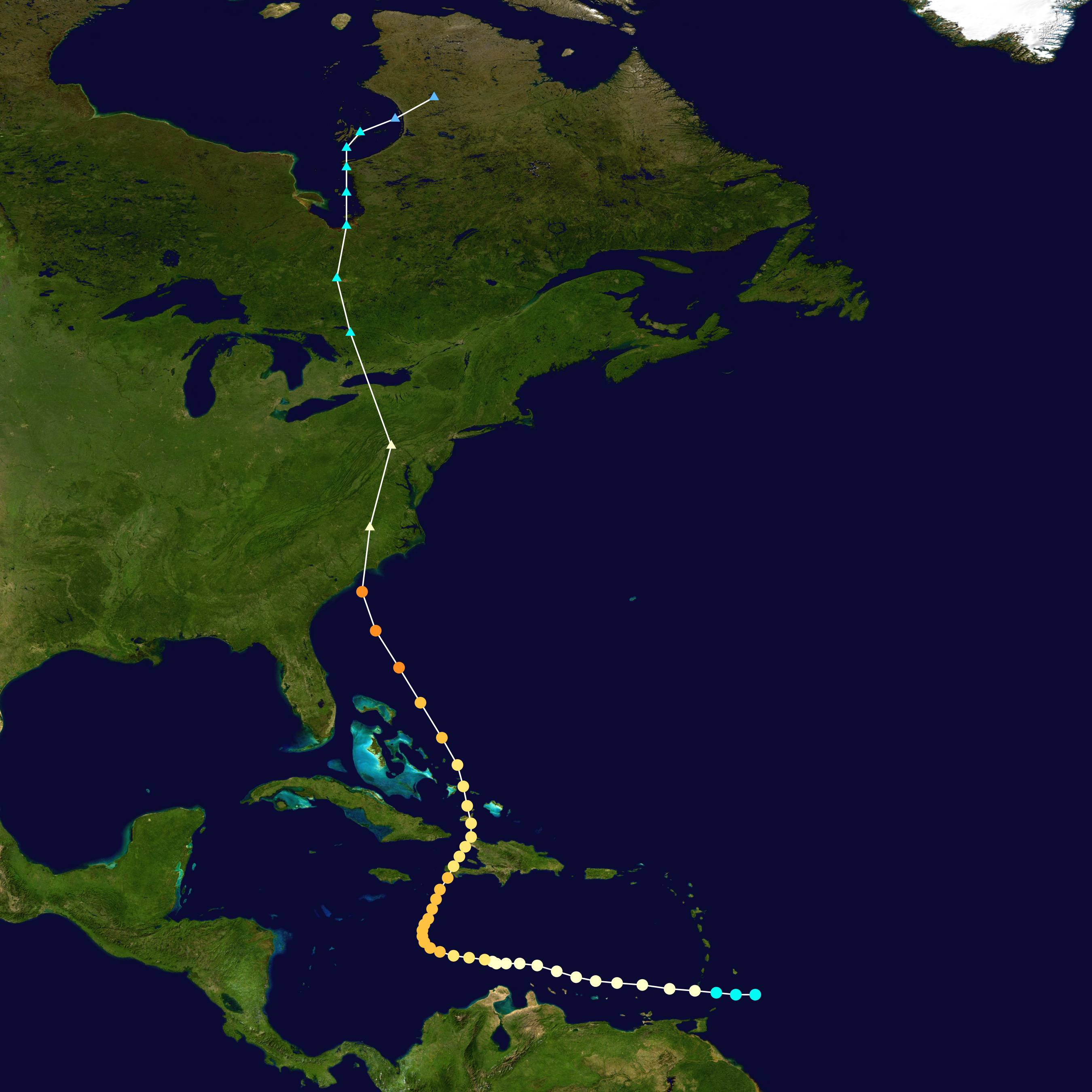 |
| Hurricane Hazel (Cat. 4 @ landfall Oct. 15, 1954) |
 |
| Hurricane Connie (Cat. 1 @landfall Aug. 12, 1955) |
 |
| Hurricane Diane (Cat. 1 @ landfall, Aug. 17, 1955) |
 |
| Hurricane Ione (Cat 1. @ landfall Sept.19, 1955) |
Sandy update
It may get a little windy (60km/h average) in the southern and eastern Ontario areas, but by far the greatest impact of Sandy continues to be in the NE US with flooding with the greatest concern, on the coast from 10-15ft of storm surge, high tide and inches of rain, and inland from all the rain. The wind in the NE US will be of hurricane force, decreasing the more time the storm center is over land.
Here are two maps showing first what has fallen over the last 24hrs and what is predicted to fall over the next 72 hours.


Here are two maps showing first what has fallen over the last 24hrs and what is predicted to fall over the next 72 hours.


Saturday, October 27, 2012
Impacts of Sandy.
Update: Oh, and let's not forget the wind.

Just a couple maps about the impacts of Sandy. She is predicted to impact the south Jersey shore Monday night with Cat. 1 hurricane force winds and a LOT of rain.
The first map is from NOAA with it's day 3 to 7 severe weather outlook. The second is a precipation total over the next five days from the GFS model. I have been so impressed with the Euro models wrt Sandy. It has been consistant over the last week. Every other model come around to its solution.


Friday, October 26, 2012
See if my comment gets published.
Update 2: My response to the response is NOT getting published.

Update: It did get published with some inane comment about Sandy is not simply a tropical storm. Pphhtt.
At a Planet3.0.org blog post... I think not. Here's a screen capture of my comment awaiting moderation.


Update: It did get published with some inane comment about Sandy is not simply a tropical storm. Pphhtt.
At a Planet3.0.org blog post... I think not. Here's a screen capture of my comment awaiting moderation.

Thursday, October 25, 2012
Putting a damper on Halloween
This from the GFS model valid next Wednesday evening. If true (the devil is in the details), that would mean rain and 40 km/h winds with gust to 80 km/h.


Latest update on Sandy
As you can see below, virtually all the models are calling for the western track with the majority calling for a landfall somewhere between Virginia and Maine around the Monday/Tuesday timeframe, with the more south landfall being earlier. Regardless, it gonna get ugly.

Wednesday, October 24, 2012
Latest model update on Sandy
Update: The Canadian is back on board..Kumbaya.
The Euro is consistant run to run with Sandy hammering the US NE. The GFS now captures it and brings it west albeit different time and location than the Euro. The Canadian has lost it and shoots Sandy out to sea.

The Euro is consistant run to run with Sandy hammering the US NE. The GFS now captures it and brings it west albeit different time and location than the Euro. The Canadian has lost it and shoots Sandy out to sea.

Sandy is going to rock the house
More and more models are coming around to the western track (see below)

If the Euro is correct (and it's been consistant), it would be a major disruptive storm. With landfall about next Tuesday, it would mean heavy rain and wind for the NE US and eastern Ontario and FEET (2-3 in some areas) of snow in the interior mountains of Western Pennsylvania and New York and significant accumulations in central Ontario. We in Ottawa may even see our first measurable snow fall from Sandy.

If the Euro is correct (and it's been consistant), it would be a major disruptive storm. With landfall about next Tuesday, it would mean heavy rain and wind for the NE US and eastern Ontario and FEET (2-3 in some areas) of snow in the interior mountains of Western Pennsylvania and New York and significant accumulations in central Ontario. We in Ottawa may even see our first measurable snow fall from Sandy.
Tuesday, October 23, 2012
Sandy, Sandy
Will cause no end of headaches. Here is a map showing the spread of model outputs (different models) for the track of Sandy. Note the ones going inland are ones like the Euro, Canadian, UKMET, JMA. The ones going out to sea are the GFS and DGEX. And even of those that are predicting landfall, the timing is varying by days.


Monday, October 22, 2012
Hooboy...
We may be looking at an ending of October and beginning of November to remember, so to speak, a la Hurricane Hazel. Some of the models are predicting this, including the Euro, Canadian and Japanese. There is a new tropical storm brewing in the Caribbean which will be "Sandy". It's currently predicted to come north over Jamaica, Cuba and the Bahamas. It is then that there is the greatest divergence of tracks with the GFS taking it out to sea. However, the latest run of the Euro pulled it in at Virginia/Pennsylvania and up into Ontario.
Stay tuned..
Stay tuned..
Ski season is starting...
In the west. Remember how I mentioned in my Oct 10th post that the ski hills of BC would be getting a whole lot whiter over the following couple of weeks. Well, it happened. Here is what Whistler looked like October 10th.
 And here is what it looks like now.


Friday, October 19, 2012
Not so Happy Halloween
The end of the month outlook is looking cool (and whitish?). You may want to let your little trickortreaters know that conditions may not be conducive to walking about the neighbourhood.
Thursday, October 18, 2012
Some more climate stuff
More of the climate been there, done that mode, there has been two papers published showing the current warm period (CWP) has been matched and exceeded in the past.
The first paper is regarding Scandanavian summer (read melt season) temperature over the last 2 millenium. Give the media hype about the Arctic Sea Ice "record" low this year, it pays to remind readers that this is not unusual. If air temperature is the only driver (and it's not!) of sea ice levels, then this study shows that temperatures in the far North have been higher for longers periods of time than currently.

The second paper is a Northern Hemispheric compilation of paleoclimate proxies which show that the Medievial Warm Period (MWP) temperatures match and exceed in some cases the CWP. Not only that, but the rate of change is also not unprecedented.

Wednesday, October 17, 2012
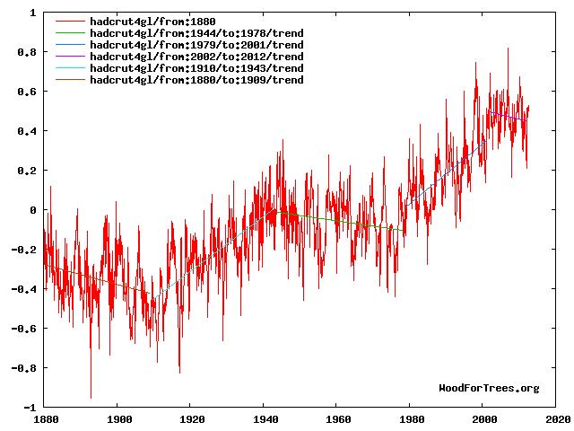
16 years of non-Global warming?
You may seen articles and stuff about a supposed 16 year pause in global warming. There's been all kinds of spin on both sides of the AGW debate. Here is my take:
Visually speaking, yes the global surface temperature in September was virtually the same as the global temperature in early 1997. Mathematically speaking, there is still a positive trend line between those two points, given all the monthly data points in between. I prefer the graph below created here.
 Some would argue that the Global temperature is dominated by the oceans and in particular the ENSO. I would argue that natural variations, including oceanic oscillations, account for the majority of the changes we have seen.
Visually speaking, yes the global surface temperature in September was virtually the same as the global temperature in early 1997. Mathematically speaking, there is still a positive trend line between those two points, given all the monthly data points in between. I prefer the graph below created here.
It shows the HADCRUT4 dataset from 1880 until now with trend lines shown in various periods. As far as I am concerned, the true starting point of the current negative trend is 2002 (ie 10years and counting) at a rate that is similar to the trendline value from the mid-1940's to the late 70's and 1880 to 1910. Note that among climate scientists, it is generally accepted that AGW supposedly began in the last half of the 20th Century. As Judy Curry notes, skeptical arguments stem in part from the "Failure of climate models to provide a consistent and convincing attribution argument for the warming from 1910-1940 and the plateau from the 1940′s to the 1970′s", ie what caused the warming in the early 20th century and what caused the cooling in the mid part?
I am not the only one who interprets the surface record this way. See pgs 21 and 22 here.
Tuesday, October 16, 2012
New rules for first snow predictions
Apparently, the flurry of snow that we had last Friday counted as a "trace" of snow. So I am changing the conditions. The predictions is now for the date of the first "measurable" amount of snow.
By the way, I have NOT received any predictions. Work with me people.
By the way, I have NOT received any predictions. Work with me people.
Monday, October 15, 2012
Winter arriving in the west
As I opined in Wednesday's post, cold and snow is coming to western Canada. Brett A. at Accuweather beat me to a detailed posting... I was/am going to post the same picture as he. Here is the GFS Ensemble temperature departures from normal (degree F) over the next week. But I'll go one further, showing the week two temperatures departures courtesy of Weatherbell which shows it still cold in the west but spreading east.


Subscribe to:
Posts (Atom)