Warming up tomorrow(Sunday) with some showers.
Cooling off Monday
Very cold Tuesday morning, possibly < -15C
Likely more snow than rain on Wednesday.
Cold again Friday morning
Beyond that the models diverge significantly...
Saturday, November 29, 2014
Monday, November 24, 2014

Cold returning briefly, big snow on east coast
Tonight into tomorrow the temperature will fall such that it will be below zero by tomorrow evening. A big storm will come up the east coast just in time for the American Thanksgiving.
Beyond that we look to be in a transitory pattern, ditty bopping around normal temps.
On a different note, are there other kids very disappointed with the melted snow or is it just mine?
Beyond that we look to be in a transitory pattern, ditty bopping around normal temps.
On a different note, are there other kids very disappointed with the melted snow or is it just mine?
Tuesday, November 18, 2014
We will lose most of the snow on the ground
A weak clipper will come through Wednesday night into Thursday.
We will have a mild few days along with some rain early next week which will take out most of the snow on the ground. But the last few days of the month look colder than normal.
We will have a mild few days along with some rain early next week which will take out most of the snow on the ground. But the last few days of the month look colder than normal.
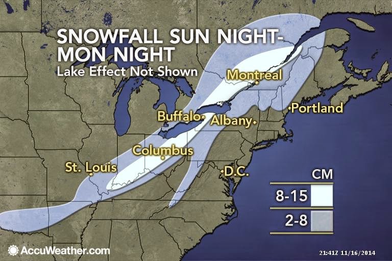
Sunday, November 16, 2014
First accumulating snow of season and more LES
Our first significant snow of the season and more Lake Effect Snow...

Snow forecast
Models have come around to the Euro idea. Here is the NAM model for total snow over the next 36 hours.

Wednesday, November 12, 2014
Euro still banging snow drum
The latest Euro has this for 24 hr snowfall ending Monday night. The other models are less enthusiastic. Something to keep watch on.


The cold is coming and some snow...
Our bit of rain this morning was the cold front passing through. Temperatures are going to drop through the day today, reaching negative values by this evening. West of us, Peterborough has dropped 10 degrees over the last nine hours to current temp of +3C. Bancroft has dropped 6 degrees over the last six hours to current temp of +2C. Petawawa has dropped 5 degrees in the last 4 hours to current +4C.
Looking forward, this cold will last at least two weeks, relative to normals. Wrt to snow, there is some consensus that Sunday will bring flurries with some light accumulation. The Euro is currently the most enthusiastic with giving us additional cms of snow on Monday.
With this strong Northwesterly flow, the typical areas for Lake Effect Snow are going to get hammered. Snow will be measured in feet in these areas over the next few days.
Monday, November 10, 2014

Sunday, November 9, 2014

Friday, November 7, 2014
Colder and colder...snowier and snowier..
The temperature anomalies of the next two weeks.


And Remembrance Day may be memorable for the wrong reason...

And Remembrance Day may be memorable for the wrong reason...
Thursday, November 6, 2014

Monday, November 3, 2014
This week and this month...
Another chance for snow this Friday/Friday night after a milder than normal week..
However, the middle third of the month looks to be colder than normal with the associated chances for snow.

The last third of the month isn't looking so hot (ha!) either...
You've been warned..winter is coming.
However, the middle third of the month looks to be colder than normal with the associated chances for snow.
The last third of the month isn't looking so hot (ha!) either...
You've been warned..winter is coming.
Subscribe to:
Posts (Atom)