Monday, April 30, 2012
This week and next
Enjoy this week's warmth. It looks like next week will have a return to cooler conditions.
Friday, April 27, 2012
Quick post
Posting is tedious typing one-handed.
Sunny and cool this weekend. Cover your precious flowers.
Warming up next week but unsettled.
Sunny and cool this weekend. Cover your precious flowers.
Warming up next week but unsettled.
Monday, April 23, 2012
Keeping today in perspective
Latest recorded snowfall in Ottawa: June 27, 1950
Latest measurable snowfall: May 25, 1961, 2.3 cm
Latest and heaviest snowfall: May 10, 1963, 15 cm
Latest measurable snowfall: May 25, 1961, 2.3 cm
Latest and heaviest snowfall: May 10, 1963, 15 cm
The rest of the week
Surprisingly I have no arguments with EC's current foecast though they may over confident with the snow on Friday. :) So I'll cut and paste their's in...(and yes, I know I am just mailing this post in)
Tonight: Periods of drizzle ending overnight then cloudy with 60 percent chance of rain showers or wet flurries. Wind northeast 20 km/h gusting to 40 becoming south 20 late this evening then light after midnight. Low plus 3.
Tuesday: Cloudy with 60 percent chance of showers. Wind becoming south 30 km/h in the morning. High plus 4. UV index 3 or moderate.
Tuesday night: Cloudy with 60 percent chance of showers. Low plus 3.
Wednesday: Cloudy with 30 percent chance of showers. High 9.
Thursday: Periods of rain. Low plus 1. High 9.
Friday: Periods of snow. Low zero. High 7.
Saturday: Sunny. Low minus 2. High 9.
Sunday: Sunny. Low minus 2. High 11.
Sunday, April 22, 2012

Friday, April 20, 2012
Two storms, two scenarios
Today/tonight's storm is coming from the southwest. Its center will be passing just south of the Ottawa region overnight tonight on a NE track. It is dragging cold air in behind it so that is why we may see some flakes tomorrow morning.
Monday's storm will come at us from the Southeast. First of all, there is now general agreement among the models with the GFS and EC moving towards the Euro solution. However that solution is also shifting west. The models are currently indicating that the storm center will pass over eastern Ontario on its way to the eastern shores of Hudson Bay. If this holds true, the cold air inplace due to today's system will cause the precip to start as snow, change over to rain and back to snow. Given the predicted track, southern Ontario may get more snow than us.
I may update this post if the afternoon Euro shows anything wildly different.
Thursday, April 19, 2012
Some changes
Friday's storm has tracked a little farther north, putting us in the rain zone. However, there is a chance for some backlash snow Saturday morning as the system departs.
Monday's storm is more interesting. The GFS has moved the storm east enough that it won't significantly impact our area. The EC now sees it but has its usual ambiguous "rain or snow" forecast. The Euro (along with the UKmet and JMA) are phasing the energy... and that's always good news. Here's a peak at the Euro snow forecast on Monday:

Monday's storm is more interesting. The GFS has moved the storm east enough that it won't significantly impact our area. The EC now sees it but has its usual ambiguous "rain or snow" forecast. The Euro (along with the UKmet and JMA) are phasing the energy... and that's always good news. Here's a peak at the Euro snow forecast on Monday:

Wednesday, April 18, 2012
No change from yesterday's post
The GFS and Euro are still seeing the potential for some sticking snow on Saturday and Monday...and EC is still not seeing it...
Tuesday, April 17, 2012
Two chances for snow in the next week
First Friday night into Saturday and then Monday. Both the GFS and Euro are seeing it..but EC is not.
Friday, April 13, 2012
Update to the rest of the week.
Tracks of the storms mentioned in the previous post are farther north in current model outputs. So it looks like we have a warmer rain. Secondly, I think we will have significant rain on Monday as opposed to EC's current non-rain forecast.
American midwest will have some fiesty tornadic activity over the next 48hrs. Look for wailing and gnashing of teeth about global warming afterwards.
American midwest will have some fiesty tornadic activity over the next 48hrs. Look for wailing and gnashing of teeth about global warming afterwards.
Thursday, April 12, 2012
Rest of the week
Nice until Sunday when a cold rain comes in. Another system that will come Tuesday will bring a thump of snow to the Amercian Midwest including Minnesota. We may get some mixed precip from that one.
Wednesday, April 11, 2012

Tuesday, April 10, 2012
End of a era...sort of...
Another pioneer of the personal computing world, Jack Tramiel, has passed away. I am one of those millions of people who spent a good chunk of our adolescence playing around with PET's, Vic20's and C64s. Good memories. Though the heyday of Commodore has been long gone, Jack's passing truly ends that era.
Monday, April 9, 2012
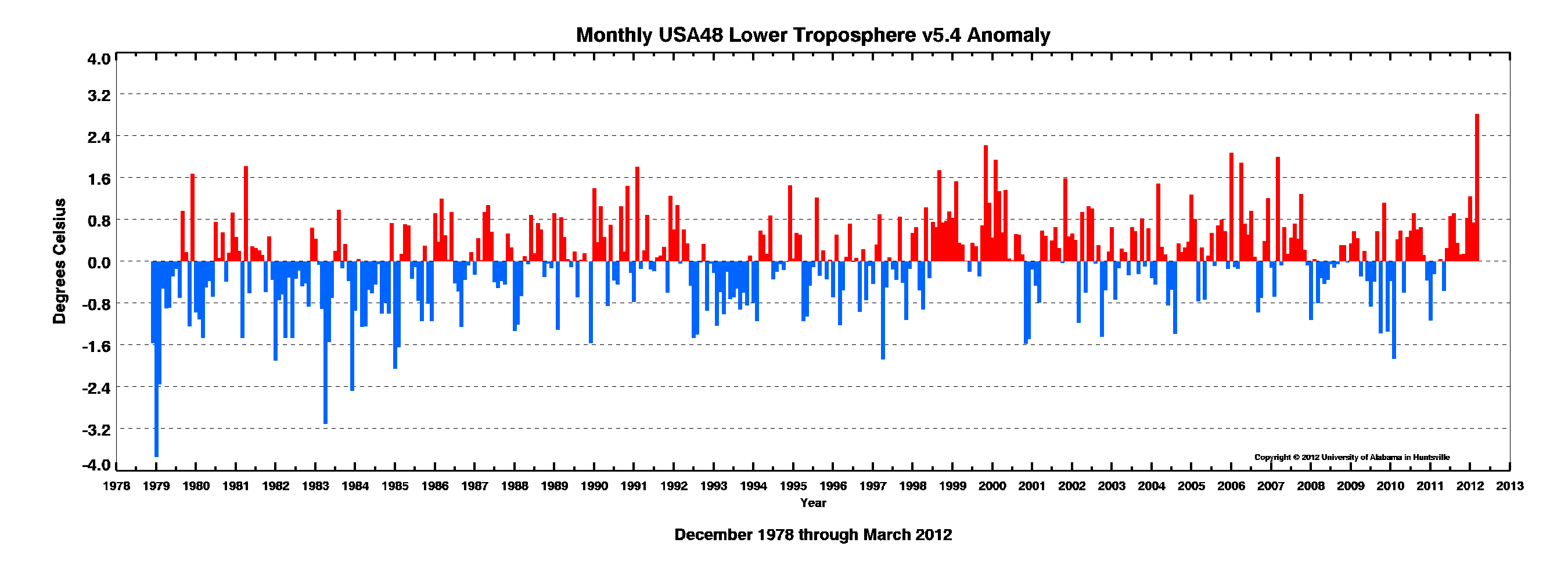
Some more perspective on the March heatwave
I have several maps and graphs to show here. The first is the temperature anomoly map of the US for the month of March. After that is a graph of the US monthly temperature anomoly graph. While noting the uniqueness of March, note as well the complete lack of pos/neg trend or increase of extremes. The next map is an overlay of the State of Alaska of the US to show some size perspective. Some notes about Alaska's winter:
- Coldest January on record
- 10th coldest March on record
- Anchorage, Alaska (among other places) had a record amount of snow.


Thursday, April 5, 2012
Tuesday, April 3, 2012
Science communication
In the comments section of the latest post on Dr. Curry's blog regarding science communication, Willis Eschenbach (occasional contributor at WUWT) make a very insightful observation regarding the state of Climate Science and the communication there-of. The incidents that Willis refers to have been covered in this blog in the past. Feel free to browse.
The rest of the week into next
The rest of the week looks very nice with about normal temps until Friday after which it'll warm up until late Sunday. At that point it looks like a cold front will come through to usher in a few days of colder than normal temps with the potential of accumulating snow about this time next week, give or take a day.
Monday, April 2, 2012
The March Heatwave
NOAA has released their preliminary analysis of the March Heat Wave. They call the event a Black Swan event, that is an event that has an extremely low probability, a very high impact, and only retrospective predictability, ie limited, if any, prospective predictability. Unfortunately, imho, they conclude with a nod to AGW with an ambiguous statement that they estimate that the magnitude of the heat wave was increased 5 to 10% by GHG effects. I've seen similar estimates for the 2011 Texas drought but there is no way to prove or measure that effect. So these estimates is purely based on model outputs, not on observations.
Subscribe to:
Comments (Atom)