Tuesday, February 28, 2012

The rest of the week

Wednesday/Thursday system: 5-10 cms of snow, less if ice and/or rain mixed in.   Right now, I think it's a mostly snow event.

Friday night Saturday system is mainly a rainy one for us.   I don't think it's getting as high as +8C on Friday as the mildest air comes in overnight Friday into Saturday morning.   During the day on Saturday a strong cold front will be passing through bringing Arctic air in.   Look for a flash freeze event on Saturday where the overnight low will get down to the negative high teens.

Updated snow map:

Monday, February 27, 2012

Snowburst

Keepcalm, this snowburst won't last long.  Moving west to east.   It'll be done in less than an hour.

Minnesota blizzard

Our storm on Thursday will first be a blizzard in Minnesota...Gerard and Deb, you've been warned.  Oh and the Saturday one is likely going to slam you too.

Sunday, February 26, 2012

Quick post

Tomorrow's storm:  meh, ie not much of anything
Thursday's storm:  alright, 5cms or so
Saturday storm:  blech, mostly rain.

Friday, February 24, 2012

Snow update

As of 5:30 PM, it looks the heavy snow will taper off in the next hour or so.    However in behind this will be intermittent snow, scattered flurries and the wind will pick up from the northwest.  So look out for blowing snow issues.

Updated snowmap

Note the shift north on snow totals.

Thought experiment

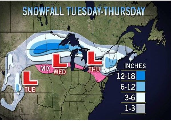
Now that it is finally snowing in Ottawa again.   I had some thoughts as to why the models got the track wrong for this storm (it's farther north than predicted yesterday).

This time of year as the sun is getting higher in the sky and the nights are shorter, it is a lot tougher to maintain cold enough temperatures for snow, especially without much snowcover.   A brief physics lesson for you.

There is a common misperception that convection (ie hot air rising) is the primary method for the cooling that happens at night.  However that isn't the case though convection does play a part.  Radiative cooling provides the majority mechanism for cooling.  This is essentially infrared radiation (aka IR, long wave radiation, LWR) going out into space.   You can tell this is the case where one can see that cloudy nights do not cool off as much as clear nights.   The clouds provide an isolative barrier for IR.   Now much of the IR comes from the ground.   When there is snowcover, there is two reasons that it helps keep things cool, one in daytime and one at night.  First snow has one of the highest albedo properties, the ability to reflect rather than absorb incoming sunlight (Shortwave radiation, SWR).   Secondly, snow, especially deep snow, provides an insolative barrier from the thermal energy in the ground.   The atmosphere cools  a lot quicker than the ground does.

So this time of year, the nights are shorter so there is less time for radiative cooling.  The sun is higher in the sky and days are longer, so there is more energy being added to the environment.   Now combine this with a lack of snowcover that we have, especially to our south from whence storm systems come, it is tough to keep it cool enough to snow.

Now as a result of the winter we have had, the water temperatures of the Great Lakes are near or at record highs.   Most computer models don't have the resolution to use the surface temperature data of the lakes as an input.  However, I think that with these relatively high temperatures are adding thermal energy as well as moisture to the systems, deviating them from the expected track.

Might be an interesting case study for some climate guy.

It's coming!

Yes, it has slowed down but the line of precip is between here and Kingston.

Thursday, February 23, 2012

Snowfall warning

When's the last time we had one of these???

Warnings

Ottawa South - Richmond - Metcalfe
3:18 PM EST Thursday 23 February 2012
Snowfall warning for
Ottawa South - Richmond - Metcalfe issued

Snow is on the way.

A low pressure system over Illinois this afternoon is forecast to track northeastward across the Lower Great Lakes tonight. Snow in advance of this system will spread into Southwestern Ontario this evening, the greater Toronto area overnight, and reach Eastern Ontario by Friday morning. Total snowfall accumulations of about 15 cm are expected for many locales along a swath from Sarnia to Cornwall.

The snow will taper off from west to east Friday afternoon and evening.

Ottawa North - Kanata - Orléans
3:18 PM EST Thursday 23 February 2012
Snowfall warning for
Ottawa North - Kanata - Orléans issued

Snow is on the way.

A low pressure system over Illinois this afternoon is forecast to track northeastward across the Lower Great Lakes tonight. Snow in advance of this system will spread into Southwestern Ontario this evening, the greater Toronto area overnight, and reach Eastern Ontario by Friday morning. Total snowfall accumulations of about 15 cm are expected for many locales along a swath from Sarnia to Cornwall.

The snow will taper off from west to east Friday afternoon and evening.

Snowmap for Friday

From our friends at A/W.

March. In like a lion?

Update Thursday afternoon:   Latest Euro is in line with the GFS below.


Mar. 1st

Mar. 4th

Wednesday, February 22, 2012

Friday's storm

What had me banging my head this morning was the Euro model.   As I explained yesterday, it was showing a significant storm as it phased energy in the northern and southern jetstreams...until I looked at the overnight run.   That run had completed pushed the system southeast and off the coast, not really affecting us at all.

But on the 12Z run, it had brought the system back in.  However, it has now a system that is on par with the other models, giving us a 6-10cm layer of snow, depending how much rain mixes in.

Did you hear that?

That was the sound of my head hitting my desk after seeing the models this morning.   More this afternoon after the midday runs come in.

On the bright side, EC's forecast for Friday is 0C and snow rather than the 3C and rain/snow it had yesterday.

Tuesday, February 21, 2012

Euro all by itself

It's the Euro against the CanGEM, GFS, NAM, JMA, and NOGAPS.   They have weakish storm that'll give us some snow and rain during the day on Friday.    The Euro on the other hand blows the storm up and gives us 9-12" of snow.  

But this winter is still a dud.

Heartland Institute, "Fakegate" and Peter Gleick

Big news in the climate science realm but not of a good kind.   The environmentalists and CAGW proponents can't seem to stop shooting themselves in the foot.

A very brief summary:  Heartland Institute is a non-profit thinktank type organization that receives private donations and in turn, funds various conferences and studies.   One of it's activities is promoting skeptical AGW views and conferences.   About a week ago, several internal documents were leaked/sent (by unknown person(s)) to pro-CAWG/alarmist blogs journalists such as "Desmogblog" which had no issue publishing them before checking their veracity.   Unfortunately for them, one of the key "damning" documents was shown to be a fake, produced by unknown person(s) to spice up the leak.    Speculation was rampant that it was Peter Gleick, a prominent and vocal climate scientist and activist was the prime suspect for the fake document and leak.  But Mr. Gleick was silent (unusually so as he is an active tweeter) on the leak issue...until yesterday.   Yesterday, Peter Gleick admitted to impersonating a Heartland Institute staff member to get access to internal documents and admitted leaking them.  But he does not admit to faking the document, the very reason people suspected him in the first place.  What an own goal!

As you might imagine there are a many many blog postings about this everywhere.   I will try to highlight a few.

Initial reaction to the leak itself:
http://rankexploits.com/musings/2012/tell-me-whats-horrible-about-this/
http://judithcurry.com/2012/02/15/heartland/
http://rogerpielkejr.blogspot.com/2012/02/reality-is-not-good-enough.html
http://climateaudit.org/2012/02/20/heartland/
http://wattsupwiththat.com/2012/02/15/some-notes-on-the-heartland-leak/

Subsequently there have been many many postings.  
http://wattsupwiththat.com/tag/heartland-institute/
http://dailybayonet.com/2012/02/fakegate-gleick-fesses-up/

One of the best analysis is from Judith Curry here:
http://judithcurry.com/2012/02/21/gleicks-integrity/   which points to the complete hypocrisy shown by these actions done for "the cause".

Also some interesting comments here in Steve M.'s Climate Audit post here:
http://climateaudit.org/2012/02/20/peter-gleick-confesses/

A good climate news aggregator is http://tomnelson.blogspot.com/  . 

Monday, February 20, 2012

Shh.. it may be working

THIS WINTER IS A DUD!

(sotto voce) The latest EC model output has lost the rain forecasted for Friday.  However they didn't update their forecast, still rain and high of +6C.  Below are a map comparison valid for Friday evening.  The left one was last night's model run.  The right one is this morning's run.  The red dot is Ottawa.

As soon as...

I declare winter a dud, the Euro makes things interesting on Friday.   It's latest run is dumping 12" of wet snow on us. 

Ha! I don't believe it.  This winter is still a dud. (see if it keeps working)

Dud Winter

Yes, that's right.  I'm officially calling it a dud.  A flat out no snowstorms, no sledding, no skating bore.   Maybe now that I've written this, we'll get a blizzard next week.  Drat, I think I just jinxed it.

In other news, I think EC is too warm this week.   Wednesday weak system will be a mix of snow and rain as will Friday's system and the potential system next Monday.  With respect to Friday's system, I will be checking what the Euro has this afternoon to see if the predicted track is moving.

The west will have another cold snap starting this coming weekend. 

Wednesday, February 15, 2012

Where winter is, Part II

Here is a graphical depiction of the three week cold wave that is happening in Europe and Western Asia.   Below it is a depiction of the forecast temperatures for the next two weeks (source).   That's at least a five week cold wave/snap, whatever you want to call it.   Do you hear much of it in the MSM?  Maybe a mention of snow damaging the Coliseum in Rome or the odd article mentioning the more than 650 related deaths.   Imagine, if you will,  if this kind of thing happened in the opposite direction, a heatwave where the temperature departures were on the positive side...but wait, it did, the Russian heat wave.  CAGW proponents were all over that....but nary a word about this cold snap...


Weekly temperature snapshot

Again, this map is showing temperature anomolies or deviations from average for the past week.

Tuesday, February 14, 2012

On the edge

Looks like Ottawa will be in that zone again where the precip could fall as snow, ice or rain.   Our saving grace, so to speak, may be that the precip will be in the evening/overnight hours Thursday.  So again, no arguments with the map below.

Today

Happy Valentine's Day.

Monday, February 13, 2012

Nothing especially exciting this week

Getting milder...again. sigh. Storms appearing and disappearing off the models.
Of moderate interest is a system coming through Thursday night/Friday. Some differences of opinion about this one again. However, I don't have much disagreement with map below at this point. I do think Environment Canada is too warm again for their forcast from Friday on:

Friday: Showers. Low minus 1. High plus 5.
Saturday: A mix of sun and cloud. Low minus 8. High minus 2.
Sunday: A mix of sun and cloud. Low minus 11. High minus 3.
Look for these forecast temperatures to come down over the next few days. 


Friday, February 10, 2012

Sigh...

The good old days.

Sometimes I despair

Me and all the other weather geeks sometimes despair at the prospects of getting a good winter storm for our area this season.   Some tasty prospects appear on the model one day, gone the next.   So yeah, those maps I posted yesterday, not there or not as potent in this morning's run.  Drat.

Thursday, February 9, 2012

Ducks are still milling around the pond.

The system on the 16th has been pushed south and offshore.   So the systems on the 18th and 22nd are still there and another one on the 24th.   And they're all looking like the storms we've had this year, sloppy.


Mountain snowpack

The snowpack in BC is at or above normal for most of the province.  The US has more of an issue with the eastern and south mountain ranges below normal.

Wednesday, February 8, 2012

Eurasian cold

I'm sure you've heard of the extreme cold wave in Europe and Asia that has killed hundreds.  Here it is in map form.  Note that this map shows anomolies for the week of Feb 1st to Feb 7th, ie deviations from normal temperatures for that time period.

What's on the table

Pictures are worth a thousand words.  Look at the top right for dates.


Tuesday, February 7, 2012

The ducks are on the pond

The ingredients are on the table...

Pick your cliche of choice.   However, it looks like next week will be the start of stormy period for our region of the globe.   Whether the precipitation comes down in the frozen form depends on whether the ingredients come together in the appropriate order or the ducks are able to get in a line (since the pond isn't frozen :)).   As of now, the GFS model has storms on the 16th, 19th and 22nd. 

As for this week, back to normal temps the remainder of this week with a pretty decent shot of colder than normal air this coming weekend (image source here).  I think EC forecast for temps are too high..again.

Dreaming of a big one...

The GFS model run from tonight has a big snow storm 10 days out.  One can dream...

Monday, February 6, 2012

Model battles

There is still a lot of uncertainty in how the remainder of this month and winter will play out for our area.   An example of this is the screengrab below of the day 8 through day 10 mean trough position and anomolies (colours) as a comparison between the GFS and Euro models.   Note the primary difference between the two models is over eastern North America and the North Atlantic/Greenland.

Wednesday, February 1, 2012