While I think the Sunday night/Monday morning system will be mostly rain, there may a mix of frozen precipitation, especially in the wee hours of Monday morning. After this system there will be a period of cooler than normal temps.
Beyond that, while there is nothing specific appearing on the models, the ingredients are on the table for winter to have another kick or two at the snowstorm can over the next 2 weeks or so.
Wednesday, March 27, 2013
Some Perspective
Last two weeks of global temperature anomolies (deviation from average)
 |
| March 13 - 19 |
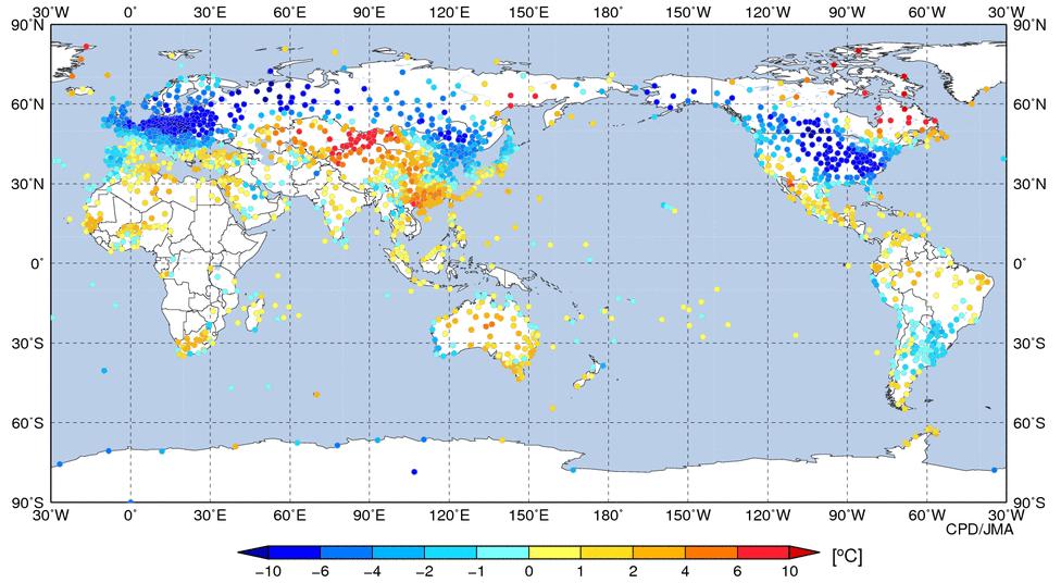 |
| March 20 - 26 |
Tuesday, March 26, 2013


Monday, March 25, 2013
Nuttin much
Nothing of interest happening our way until things get messy next week including a possible April Fools joke.
Thursday, March 21, 2013
A period of blah and boring.
The next week or so is going to be blah, nothing much happening, normal to below normal temps, scattered flurries and snow, but nothing major appears on the models for us. The system I mentioned for early next week is skirting south of Ontario and will give the mid US a pretty good storm.

As I mentioned earlier this week, the temps for the weekend won't be as high as Env. Can. predicts. They've reduced their forecast to the low single digits but I still think we'll be lucky even to cross 0C.

As I mentioned earlier this week, the temps for the weekend won't be as high as Env. Can. predicts. They've reduced their forecast to the low single digits but I still think we'll be lucky even to cross 0C.
March to date.
Just to get an idea of the contrast between this March and last March.
 |
| March 1 - 19, 2012 Temp Anomaly |
 |
| March 1 - 19, 2013 Temp Anomaly |
Wednesday, March 20, 2013
Oh ye of short memory
The last few years worth of Marches have reeeeeeeally spoiled the lot of you, especially last year with it's crazy warmth.
Let me take you back a short 5 years ago to March of 2008. The full dataset is here for Ottawa but let me give some highlights:
Mar. 5th: 29cm snowstorm
Mar. 7/8th: 45cm snowstorm
Mar. 19th 5 cm storm
The snow depth at its peak was 87 cms on March 14th.
Let me take you back a short 5 years ago to March of 2008. The full dataset is here for Ottawa but let me give some highlights:
Mar. 5th: 29cm snowstorm
Mar. 7/8th: 45cm snowstorm
Mar. 19th 5 cm storm
The snow depth at its peak was 87 cms on March 14th.
Tuesday, March 19, 2013
Now and longer term
As I haven't been outside since this morning, it's hard for me to judge how much snow we've received since last night. This morning it looked like about 10cm on the driveway but I am not sure how much of that drifted in. If correct, then I'd expect we will get about 15 cm by this evening which is on the low end of what was predicted yesterday. Montreal has received 27cm so far and there's a bunch more to come for them.
Longer term, the GFS is saying we'll do this all over again in a week's time while the Euro pushes the storm well south to the mid-atlantic US.
Even longer term the next week is looking like this temperature wise (courtesy of Weatherbell):
 My wife moved to Ottawa from the Fraser Valley in BC almost 13 years ago. The first time it snowed on her birthday (early April of 2001), she was enormously peeved. Let's just say I'm keeping my head down this year....again.
Longer term, the GFS is saying we'll do this all over again in a week's time while the Euro pushes the storm well south to the mid-atlantic US.
Even longer term the next week is looking like this temperature wise (courtesy of Weatherbell):
Don't want to rub it in or anything...
But last year at this time we were at day 2 of a 5 day stretch where daily high temperatures were in the mid to high 20's Centigrade...
A centimeter so far
Just came home from hockey and about 1 cm feel whilst I was playing. However the radar is making me nervous. Unless there are some serious dynamics changes, I see us struggling to get to 10cm, let alone 15 to 20.
Monday, March 18, 2013
Latest
It's looking like 15-20 cms for the Ottawa Area. The extreme eastern parts of Ontario into Quebec have snowfall warnings as they are predicting 20-30 cms but those amounts could easily poke a nose into Ottawa proper. But the opposite is true as well, where the precip doesn't come as hard as predicted and we get less..
One other thing. Env. Can is currently predicting highs of +7 and +8 C on the weekend. I ain't buying it, although there is some support in other models. My primary reason is that there is a light wind straight out of the north predicted for that period as well. So I am not sure how a light northerly wind over snow cover will give us a high temp that is several degrees above normal...
One other thing. Env. Can is currently predicting highs of +7 and +8 C on the weekend. I ain't buying it, although there is some support in other models. My primary reason is that there is a light wind straight out of the north predicted for that period as well. So I am not sure how a light northerly wind over snow cover will give us a high temp that is several degrees above normal...
Accumulations from various models
The models have once again backed down somewhat from previous snow totals. I still tend to think we will locally get 6+ inches of snow. But there is still a chance that a band of intense precip will drop more on a locallized area.
Below are some snowfall accumulation maps with an end time of tomorrow evening, courtesy of WeatherBell and Accuweather.


Below are some snowfall accumulation maps with an end time of tomorrow evening, courtesy of WeatherBell and Accuweather.


Sunday, March 17, 2013
Updated snowmap
Did I call it or did I call it???


Plus a timing map for those thinking of roadtrips.

Snowmap
Courtesy of Accuweather. Personally, I think the 6-12 area needs to cover all of Eastern Ontario Kingston and east.


Friday, March 15, 2013
Next Tuesday
As of this afternoon, Tuesday's storm is still on. It'll be another wet sloppy one with accumulations being predicted to be anywhere in the 15 - 30 cm range.
Thursday, March 14, 2013
News from the We't Coast
AWCN11 CWVR 141446
Special weather summary for coastal British Columbia issued by Environment Canada at 7:44 AM PDT Thursday 14 March 2013.
The strongest systems in a series of very moist Pacific frontal systems have now moved inland and heavy rain has eased over most of the South Coast. Another system will approach the South Coast today
bringing more rain, but rainfall amounts are expected to remain below warning criteria.
All rainfall warnings have now been ended.
Storm total precipitation amounts since rain began Monday to 6:00 AM
PDT Thursday (65 hours):
Metro Vancouver:
Yvr 31.4 mm
North Vancouver 127.6 mm
West Vancouver 109.3 mm
Coquitlam 112.4 mm
Pitt Meadows 96.9 mm
Fraser Valley:
Abbotsford 76.9 mm
Ubc research 145.0 mm
Agassiz 76.6 mm
Chilliwack 61.6 mm
Hope 59.2 mm
Howe Sound:
Squamish 108.2 mm
West Vancouver Island:
Tofino 153 mm
Kennedy lake 181.4 mm
Will the kids finally get a snow day?
Not much change in the models. Tuesday's storm is still looking like a 3-6 incher, with start time of early Tuesday morning.
In other news, spring delayed to April...probably.
In other news, spring delayed to April...probably.
Wednesday, March 13, 2013
The next few days...
Tuesday, March 12, 2013
Saturday and Tuesday
First, I am not quite getting the latest Env. Can forecast for Saturday (Saturday: A mix of sun and cloud with 30 percent chance of flurries. Low minus 11. High minus 6.). It differs significantly from the Env. Can. model which is showing a significant clipper coming through Saturday morning giving us 5-10cms of snow. So either Env. Can. has changed policy and forecasts do not necessarily follow the Env. Can. model or the meteorologist assigned to the region neglected to update the forecast. I think it's the latter. This all being said, the Euro is agreeing with the GEM (Env. Can. model) but the GFS and JMA are diving the clipper south of us, not giving us much of anything. I will stick with the Euro and say that we will get a shovelable snow Friday night/Saturday morning.
Much to my disappointment but not to my surprise, the models have backed off from the monster storm next Tuesday for our area (the NE US may get clocked yet). However there is general agreement of a 10-15 cm type event. But that's a week away yet, things may coalesce yet.
Much to my disappointment but not to my surprise, the models have backed off from the monster storm next Tuesday for our area (the NE US may get clocked yet). However there is general agreement of a 10-15 cm type event. But that's a week away yet, things may coalesce yet.
Monday, March 11, 2013
Booyah!
Okay, I must say the latest models have made me drool...more than usual anyway. Remember about a week ago, I posted about a monster storm coming. For the past while it had "dissappeared" off the models or wasn't very significant. But yesterday afternoon's version of the Euro showed a big storm again and now the latest GFS has joined in for a storm around next Tuesday. And they're both showing a snow storm hammering all of southern and eastern Ontario with 30+cms of snow. I am showing you part of a map from the Euro that show the snowfall totals for the next 9 days. I know it may be hard to see, so for reference, Ottawa is at the top of the red triangle-ish 18 inch line and the bottom is right around Kingston.
 I'm trying not to get too excited about this prospect as it is more than a week away, but I'll be watching this closely.
In the near term, mostly rain tonight into tomorrow. Cooler temps come in Wednesday for a few days. Saturday looks like a clipper coming through southern Ont that will put a few cms down in Ottawa.

In the near term, mostly rain tonight into tomorrow. Cooler temps come in Wednesday for a few days. Saturday looks like a clipper coming through southern Ont that will put a few cms down in Ottawa.
Rainforests
Remember when the rainforests were all going to dissappear because of global warming? Well, nevermind.
Friday, March 8, 2013
All over the place
With respect to the Monday/Tuesday system on the models.
The Euro has shift north. The GFS south. As of now, we will get little else but rain.
Here's hoping we get a mix of the two.
The Euro has shift north. The GFS south. As of now, we will get little else but rain.
Here's hoping we get a mix of the two.
Comment to and response from Env. Can.
I had noticed that Env. Can. observations at the Ottawa A/P were way off for the last storm so I provided the following feedback via their website:
There are some significant issues with the observation equipment at Ottawa INT'L. For example, for February 27th, the hourly observations note only "Snow Showers" for the afternoon when heavy wet snow was the reality. Secondly, the daily data shows a total snow amount of 14.2 cms while the reality was approx double that at 25-30cms (compare with Ottawa CDA station total snow of 29 cms).
This is the response:
Hello Fred Nieuwenhuis,
Your request was forwarded to our office. Thank you for your feedback. In response to your comments, the weather conditions are reported by human observers. For the amounts, we have received a lot of complaints indicating that the snowfall amount reported by Ottawa Int'l were too low for the February 27th storm. You will find below an explanation of the differences. I am unable to advise you on what information you will use, - maybe the official numbers with a reference to other reliable sources - these can be the weather summary (see link below) and the data from the Ottawa CDA site.
The amount of snowfall recorded at Ottawa Int'l was 14.2 cm with a water equivalent of 25 mm. This snow was very wet and there was a lot of compaction with the moisture. In the hourly weather reports issued from the airport for this date, Ice pellets were reported, and this would definitely produce heavy solid snow. There were high winds during the storm, and as in the past, the observation site at the airport probably did not capture the snow within its measuring area - snow may have blown elsewhere.
The other site in Ottawa at the CDA reported 29 cm. This location may have a more protected snow measuring area.
http://climate.weatheroffice.gc.ca/climateData/dailydata_e.html?timeframe=2&Prov=ONT&StationID=4333&dlyRange=1889-11-01|2013-02-27&Year=2013&Month=2&Day=01
This was truly a very messy storm. The amounts of snowfall were variable based on the location of measurement, and it may have depended on when the snow was measured. The wetness and weight of the snow reduced the depth if it was not measured at the right time. If the temperature was a bit colder, then the snow was less dense. If the temperature was warmer, then the snow may have melted almost immediately.
- link to weather summary bulletin issued after the storm, reporting 25-30 cm for the Ottawa area:
http://dd.weatheroffice.ec.gc.ca/bulletins/alphanumeric/20130228/AW/CWTO/16/AWCN11_CWTO_281619___71428
We have created a spreadsheet with the raw bulletins from Ottawa Int'l and we have posted it on our ftp site to assist clients looking for the missing data. This information is in the files Ottawa 2012 and 2013. Please note that this information is raw data, and is subject to corrections at a later date.
To access, link to: ftp://wtoftpa.on.ec.gc.ca
Username: ontarioclimate
Password: 4climateData (case sensitive)
I hope the information provided will be helpful. Do not hesitate to contact us if you have additional questions or comments.
....
I think I will provide further comment because there is several issues with the response:
- the human observers obviously need training to distinguish between snow showers and heavy snow.
- wet snow doesn't blow around. Once it hits ground it sticks.
- the location dependency, while true in a general sense doesn't hold water in this case. I live just a few kms as the crow flies from the a/p and there was definitely close to 30cm of snow. I shovelled it.
There are some significant issues with the observation equipment at Ottawa INT'L. For example, for February 27th, the hourly observations note only "Snow Showers" for the afternoon when heavy wet snow was the reality. Secondly, the daily data shows a total snow amount of 14.2 cms while the reality was approx double that at 25-30cms (compare with Ottawa CDA station total snow of 29 cms).
This is the response:
----- Original Message -----
From: Ontario Climate Centre
Sent: Thursday, March 07, 2013 4:36 PM
Subject: RE: Environment Canada Ser: C0306CZLEB NIRT:0005958
Your request was forwarded to our office. Thank you for your feedback. In response to your comments, the weather conditions are reported by human observers. For the amounts, we have received a lot of complaints indicating that the snowfall amount reported by Ottawa Int'l were too low for the February 27th storm. You will find below an explanation of the differences. I am unable to advise you on what information you will use, - maybe the official numbers with a reference to other reliable sources - these can be the weather summary (see link below) and the data from the Ottawa CDA site.
The amount of snowfall recorded at Ottawa Int'l was 14.2 cm with a water equivalent of 25 mm. This snow was very wet and there was a lot of compaction with the moisture. In the hourly weather reports issued from the airport for this date, Ice pellets were reported, and this would definitely produce heavy solid snow. There were high winds during the storm, and as in the past, the observation site at the airport probably did not capture the snow within its measuring area - snow may have blown elsewhere.
The other site in Ottawa at the CDA reported 29 cm. This location may have a more protected snow measuring area.
http://climate.weatheroffice.gc.ca/climateData/dailydata_e.html?timeframe=2&Prov=ONT&StationID=4333&dlyRange=1889-11-01|2013-02-27&Year=2013&Month=2&Day=01
This was truly a very messy storm. The amounts of snowfall were variable based on the location of measurement, and it may have depended on when the snow was measured. The wetness and weight of the snow reduced the depth if it was not measured at the right time. If the temperature was a bit colder, then the snow was less dense. If the temperature was warmer, then the snow may have melted almost immediately.
- link to weather summary bulletin issued after the storm, reporting 25-30 cm for the Ottawa area:
http://dd.weatheroffice.ec.gc.ca/bulletins/alphanumeric/20130228/AW/CWTO/16/AWCN11_CWTO_281619___71428
We have created a spreadsheet with the raw bulletins from Ottawa Int'l and we have posted it on our ftp site to assist clients looking for the missing data. This information is in the files Ottawa 2012 and 2013. Please note that this information is raw data, and is subject to corrections at a later date.
To access, link to: ftp://wtoftpa.on.ec.gc.ca
Username: ontarioclimate
Password: 4climateData (case sensitive)
I hope the information provided will be helpful. Do not hesitate to contact us if you have additional questions or comments.
....
I think I will provide further comment because there is several issues with the response:
- the human observers obviously need training to distinguish between snow showers and heavy snow.
- wet snow doesn't blow around. Once it hits ground it sticks.
- the location dependency, while true in a general sense doesn't hold water in this case. I live just a few kms as the crow flies from the a/p and there was definitely close to 30cm of snow. I shovelled it.
Time change this weekend
Change your clocks 1hr ahead tomorrow night. You're getting 1 hr less sleep! Ughh, like I need any less sleep.
Thursday, March 7, 2013
Monday's storm
Yes the timeframe has shifted from Tuesday to Monday. This is largely due to the models catching on to the splitting of the energy. The first piece will form a system that will pass to our north heading for northern Quebec. We will be in the warm sector which will bring us showers overnight Sunday into Monday morning until the cold front behind the first system comes through. The second piece will be riding the frontal boundery. Currently it is looking like we'll get 5-10cm of wet snow later on Monday.
This all being said, there is a fair amount of disagreement with how all this plays out so stayed tuned.
This all being said, there is a fair amount of disagreement with how all this plays out so stayed tuned.
Wednesday, March 6, 2013
Talk about a divergence
Lunchtime update: The latest GFS has come around to a Euro type solution...so stay tuned.
Regarding next Tuesday's system.
The GFS drives the storm over the central Great Lakes so by Tuesday morning the storm center is just east of James Bay. This solution would give a most rain event with a brief change over to snow as the trailing cold front comes through.
The Euro takes the storm just south of the lower Great lakes (Erie & Ontario) such that the storm center is over northern New York state Tuesday morning. This solution would give us another thump of heavy wet snow.
Guess which solution I'm rooting for.
Tuesday, March 5, 2013
Next week..
Since this week is pretty blah (enjoy those temperatures by the way), I will look into next week.
Our first weather feature of note will be Monday into Tuesday. As of now, the GFS is giving us a mostly rain event whilst the Euro is giving us a mostly snow event. Given track records, I'd go with the snow.
Beyond the above system, the models diverge. The GFS has most of Canada colder than normal past day eight (next Thursday-ish), while the Euro has the cold more concentrated in the plains. Given the GFS had overdone the cold this past weekend from a few days earlier, I'd tend to think that we'll have more normal temps to perhaps a little below normal during that period.
Both models have a monster storm in and around day 12...stay tuned.
I don't think the prairies are in for spring any time soon. Spring for us may have to wait until the end of March...
Monday, March 4, 2013


Friday, March 1, 2013
Meh...
Looks we are in a "meh" weather period with nothing much happening from the next week or so. The US mid-atlantic states are looking to get pounded the middle of next week but we won't feel and effects of that.
Subscribe to:
Comments (Atom)