Friday, July 26, 2013
March 2012 heat wave
Remember that heat wave last year where we had record high temperatures over most of the continent that had all the alarmists soiling themselves over attribution to Global Warming? Well that cause is apparently wrong. A new study shows it's due to natural weather variations. The take-home conlusion from the study: "We conclude that the extreme warmth over the central and eastern U.S. in March 2012 resulted primarily from natural climate and weather variability, a substantial fraction of which was predictable."
Thursday, July 25, 2013
Next week
For those of you holidaying next week, this one's for you.
Frontal precipitation on Sunday will bleed into Monday with scattered showers.
The week will start coolish. The warmest day likely will be Wednesday. Highs will be in the low to mid 20's and lows in the low teens, maybe dipping into single digits depending where you are.
It's currently looking like the last part of the week will be unsettled as well.
Saturday, July 20, 2013
In the opinion of this weather geek
There weren't any tornados in the Ottawa area. Based on my observations of the conditions and viewing of pictures in news media like the one below from Barrhaven, I am fairly certain that what was seen are primarily low, fast moving shelf clouds looking like tornadoes due to perspective. And any damage was primarily from straight line winds.
I was there in the Grand Valley tornado of '85 so I know what tornado producing weather looks like.

I was there in the Grand Valley tornado of '85 so I know what tornado producing weather looks like.

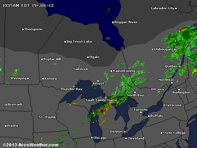
Friday, July 19, 2013
Warnings in Southern Ontario...
It ain't over until later tonight.

In our neck of the woods the warning is:
Ottawa North - Kanata - Orléans
2:40 PM EDT Friday 19 July 2013
Severe thunderstorm warning for
Ottawa North - Kanata - Orléans continued
At 2:30 EDT, meteorologists are tracking a line of severe thunderstorms extending from Georgian Bay to just west of Ottawa and into Quebec.
These are dangerous storms. A roof has been reported blown down in the Petawawa area and trees have been blown down.
The thunderstorms are moving eastward at 70 km/h and are capable of producing damaging winds as well as the threat for a tornado.
Emergency Management Ontario recommends that you take cover immediately, if threatening weather approaches.
Strong wind gusts and hail can damage property and cause injuries. Local downpours can cause flash floods.
Go indoors and move away from windows and skylights. Avoid areas of the building that could be affected by falling debris such as tree limbs. Stay on the lower floor of your home or building and if the storm is particularly severe go to the basement.
Avoid driving through water on roads. Even shallow fast moving water across a road can sweep a vehicle away.
Remember, severe thunderstorms can produce tornadoes.
Tornados???
1:13 PM update: Pembroke getting hammered now. A few popcorn storms are appearing in advance of the main line.
As I postulated on Tuesday, there is a strong cold front coming through later today bringing cooler temperatures for a few days.
However, its approach will also stimulate some feisty weather. Env. Can. has issued a Tornado Watch. I think is interesting because they haven't issuing a Severe Thunderstorm watch and, as you know, one begets the other. Anyway, it is unlikely but not out of the realm of possibility that a tornado will spin up.
The main line of severe weather is crossing Georgian Bay right now but individual storm may pop up in advance of it.
Just be aware.
As I postulated on Tuesday, there is a strong cold front coming through later today bringing cooler temperatures for a few days.
However, its approach will also stimulate some feisty weather. Env. Can. has issued a Tornado Watch. I think is interesting because they haven't issuing a Severe Thunderstorm watch and, as you know, one begets the other. Anyway, it is unlikely but not out of the realm of possibility that a tornado will spin up.
The main line of severe weather is crossing Georgian Bay right now but individual storm may pop up in advance of it.

Just be aware.
Thursday, July 18, 2013

Next few weeks and winter, again.
To begin with some good news: this week is likely the hottest week of the summer. We likely won't see these temperatures again this year.
Next week starts nice, ends not so nice, ie cool and unsettled.
The coolness is seeming to continue in the following weeks:
Five day period temperature anomaly starting the 28th:

Five day period temperature anomaly starting Aug 4th:

From the same model, December temps:

And January:

From the JAMSTEC model, their winter temperature forecast:

Next week starts nice, ends not so nice, ie cool and unsettled.
The coolness is seeming to continue in the following weeks:
Five day period temperature anomaly starting the 28th:


Wednesday, July 17, 2013
T-storms on the way
Radar is show thunderstorms developing and moving SE down the Ottawa river valley. They are currently in the Pembroke area. So they will hit us later this afternoon.
Keep your head up.
Keep your head up.
Tuesday, July 16, 2013
When's the heat going to end?
There will be a weak cool front pushing down on Thursday which will kick off some unsettled weather. The big cool down will happen Friday night as a strong cool front will pass through bring cooler temperatures for a few days.
Thursday, July 11, 2013
Next week, longer term and winter...
Since the near term is working out per my thoughts on Monday, I'll focus on next week and beyond.
This stretch of benign weather may stretch all the way to next Wednesday, albeit with increasing heat and humidity, when a front starts pressing down causing increased chances of disturbed weather for the last half of the week.
This frontal boundry will begin a weather pattern that is showing a tendancy for a trough in the eastern part of the continent. Back in 2007, the last time my family went camping, the week we went in August was windy and cool. We are finally going camping again the week of the 27th. This troughiness tendancy is making me nervous for at least a portion of the time that we are camping as well as the following week when some of my kids are at camp.
Longer term, the CFSv2 model is indicating an early start to winter. Just to keep you in the loop.
Monday, July 8, 2013
The week
Starting Thursday we are going to get a few days of nice comfortable weather. I think Friday and Saturday are going to be very nice.
Until then unsettled and humid.
Until then unsettled and humid.

Thursday, July 4, 2013
Wednesday, July 3, 2013
More AGW spin
Update: CTV News seems to be blocking any of my comments...figures.
See Associated press article shown here and here.
Compare with what is actually printed in the WMO report:
"disaster..data do not demonstrate that the increase in observed losses is caused by an increase in the frequency and intensity of extreme events"
"No clear trend has been found in tropical cyclones and extra-tropical storms at the global level"
"Distinguishing between natural climate variability and human-induced climate change will also require datasets that are more complete and long-term."
It also ignores this inconvenient fact, the Global mean surface temperature is decreasing:

Subscribe to:
Posts (Atom)