
Friday, March 30, 2012
This weekend...
Haven't mentioned this cuz it doesn't affect us but Southern Ont. is getting a wee thump of snow tonight (see below). Our chance may be Sunday night but again, if only the precip lasts long enough until the cold air comes in.

Thursday, March 29, 2012
Wednesday, March 28, 2012
Monday, March 26, 2012
Snow...
I think our best chance for snow in the next week is overnight Wednesday/early Thursday morning. We may wake up with a little bit of white stuff on the ground if the precipitation can last long enough for the cold air to come in.
The models are all over the place with next week. So anything is possible at this point.
The models are all over the place with next week. So anything is possible at this point.
Ken Reeves
My favourite guy at Accuweather since JB left has passed away. He fell off his roof taking Christmas Lights down.
http://www.accuweather.com/en/weather-news/accuweathers-ken-reeves-passes/63239
http://www.accuweather.com/en/weather-news/accuweathers-ken-reeves-passes/63239
Sunday, March 25, 2012

Friday, March 23, 2012
Land cover/use change

At this time, I will remind readers that the only reasons CO2 is being blamed for AGW is that
- it is known to be a "greenhouse" gas,
- it has been increasing in the atmosphere, especially in the last 100 years and
- there has been a global temperature (GMST) increase of less than two degrees in that time period as well.
So there is a moderate (not a strong) co-relation between atmospheric CO2 levels and GMST, plus the "greenhouse" theory plus model outputs and there's your Global Warming scaremongering about the CO2 strawman.
Many alarmist climate "scientists" think CO2 is the single most important forcing that's causes global warming/climate change/climate disruption/whatever have you. But there is growing contingent of science that think that Land cover/use change has as large or larger impact on the climate as CO2 (RPS has been banging this drum forever with little impact). It has effects on albedo, wind patterns, boundry layers, carbon sink/source values, etc. and etc. Definitely not an insignificant role.
Thursday, March 22, 2012
Temperatures
This is about as warm as we are going to get for a while as a "backdoor" cold front presses through this afternoon/evening. A stronger front will come through on Sunday making early next week temperatures pretty close to normal.
Global temperature snapshot for the past week:
Global temperature snapshot for the past week:
 |
Wednesday, March 21, 2012

Tuesday, March 20, 2012
Confirmation of what I've been saying.
Here is confirmation of what I've been posting and telling people. From an actual meteorologist who also happens to believe in AGW. Here is a excerpt of his blog post:
Why did this happen?
It may be easy for someone to go and say that it was just global warming or La Nina, but it is not that easy. We are looking at several factors that just happen to come together for an extended period to produce this pattern. Some of those factors are.......
1. Unusually sustained, record positive phase of the Arctic Oscillation produced stronger west to east jet stream into southern Canada and the northern U.S. which spread Pacific air across the continent and trapped the Arctic air far to the north.
2. North Atlantic Oscillation mostly in a positive phase. (lack of blocking)
3. Stronger western Atlantic high pressure ridge.
4. Sea ice?
5. Lack of snow cover from the Prairies to the eastern U.S. allowed cold air masses to modify as they tracked south and east. The darker, bare ground also absorbs more heat than snow/ice cover.
6. La Nina played some role, but not sure it was as much as we thought.
7. Warmer than normal sea surface temperatures over the Great Lakes and off the East Coast.
In terms of global warming, we have to remember that this is just one season over a relatively small part of the Earth (North America). Yes, the planet is warming, but we just do not have enough data to link this past winter to global warming. Now, if we see a steady increase in winters like this from North America to Asia over the next few decades then we may be able to establish a more concrete link.

Monday, March 19, 2012
Everybody on the bandwagon!
It's a good time to be a weather enthusiast because everybody is talking about the weather. And there is plenty to talk about... Well actually, only one thing right now in our neck of the woods and that is the balmy temperatures (we won't mention the snowstorm in Arizona). We are having May and June like temperatures. Records are being blasted and beaten like a rented mule, left, right and center. And these positive temp anomalies will continue for a while, albeit reduced somewhat by the end of the month in certain areas.
Naturally, the question comes: is this Global Warming? Some would predictably say yes... I would say no, again predictably. Climate/weather always changes and unique circumstances can always occur. If you remember back in my December 22nd post, I commented how we were in a relatively unique atmospheric weather situation. That continued throughout the winter. Alaska had its coldest January on record. Eastern Europe had record cold and snows in February as did Northern China. But we had warm temperatures and a lack of snowstorms, especially in the eastern half of the N. American Continent. As a result we have a lack of snowcover (4th lowest N.America winter on record) and record high Great Lake temperatures. So any strong southerly flow of air will be un-moderated, un-cooled and ripe for breaking records. And that is what is happening big time.
So both the current AND preceding weather patterns are responsible for our current weather. Enjoy it. It may lead to a cooler than normal summer.
Update Mar.22nd: I've added a couple links to show my points about a global view of weather.
Friday, March 16, 2012
This winter...from NASA
Funnily enough, nary a word about AGW or Climate change, just two naturally occurring phenomenon, La Nina and the Arctic Oscillation.
http://www.nasa.gov/topics/earth/features/2012-snow.html
http://www.nasa.gov/topics/earth/features/2012-snow.html
Enjoy the warm temperatures
They'll last another 7 to 10 days. Indications are that we'll likely come back to normal by the end of the month.
Wednesday, March 14, 2012

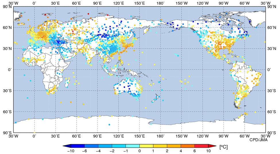
Weekly temperature update
Lest you think our warm temperatures are global in nature:
 |
Friday, March 9, 2012
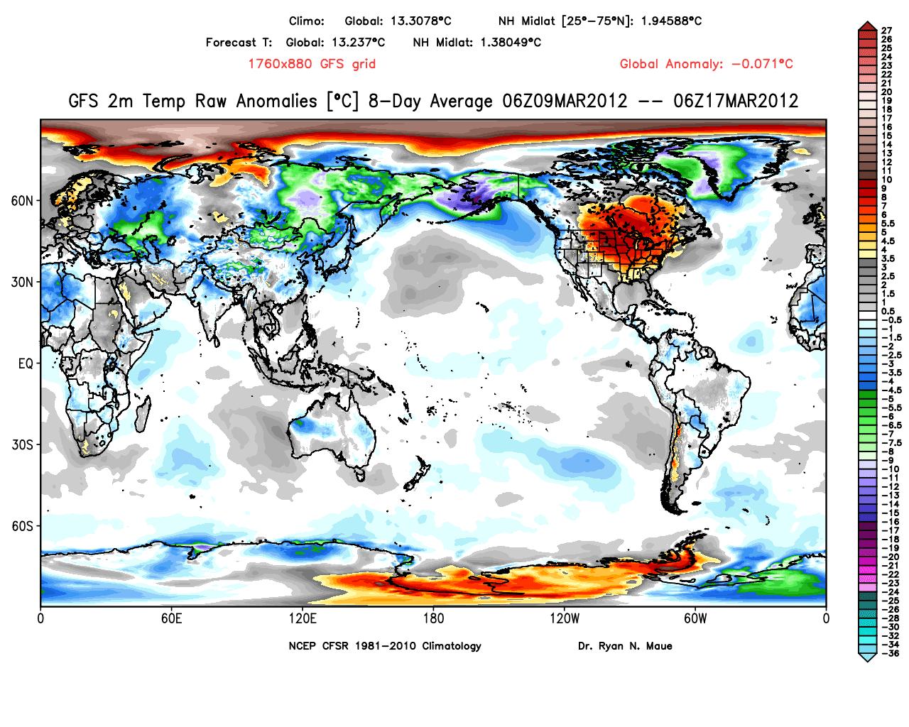
Next two weeks of temps
Welcome to spring weather. Here are the next two weeks of temperature anomolies (based on the GFS model, source). Note that there are going to be record highs broken in the big orange spot which includes Ottawa, and that is entirely due to the lack of snow cover in those areas, compared to normal due to the kind of winter we have had. Note the continuing cold in eastern Eurasia and Alaska.

Thursday, March 8, 2012
World and Canadian Arctic temps
Below is a snapshot of world temperature anomolies for the week Feb. 29th to Mar. 6th. I noticed that the Canadian Arctic is shown colder than normal. I wondered how cold. The data tables below list the actual mean and normal mean temperatures for the week ending March 5th. Brrrrr...


Wednesday, March 7, 2012
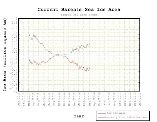
That time of year
This is the time of year when sea ice discussions ramp up.
Antarctic sea ice has reached its minimum extent/area on the positive side. Its long term trend is also on the positive side. So much for melting poles.
The Arctic sea ice is nearing its maximum. Arctic sea ice has had an interesting growth season. The areas(Hudson Bay and Baffin Straight) last year which had significant negative anomolies are doing just fine now. For example the Baffin Straight/Newfoundland coast has almost 500K sq.km more sea ice than this time last year. This year the Barent and Kara Sea are well below average. But the Bering Sea is well above normal. So overall we are within 500K sq.kms of normal, with in 1 standard deviation from normal.


Well, I am officially...wrong about today
As of 12 PM, it's +10C (at the airport) which means even if it does not go up any more (likely will), 10 is closer to 12 than my 6 and EC was more right than me.
So why? I dunno. I've shown in the past how EC models have over estimated temperatures, even daytime temps. So I can't say why they were successful today over other models that, historically speaking, are better. I admit it, I'm stumped.
But there is still tomorrows temps. That is still on.
So why? I dunno. I've shown in the past how EC models have over estimated temperatures, even daytime temps. So I can't say why they were successful today over other models that, historically speaking, are better. I admit it, I'm stumped.
But there is still tomorrows temps. That is still on.
Tuesday, March 6, 2012
Seriously??
EC is predicting a high of +12 degrees tomorrow. So is TWN which is troubling... But it's only the Canadian model that is showing that high of a temp. The Euro, GFS and NAM show temps in the mid single digits. In fact the GFS and NAM show Thursday warmer than Wednesday. EC has +8 and +7 C as the high and low temp respectively on Thursday. So, my prediction:
Wednesday: High temp of +6C and a low of -4C reached early in the morning.
Thursday: High temp of +8C and a low of -1C reached late Thursday as the cold front comes through
Light snow shower on Friday as a very weak clipper passes through and a brisk north wind.
Let's see who's more accurate.
Wednesday: High temp of +6C and a low of -4C reached early in the morning.
Thursday: High temp of +8C and a low of -1C reached late Thursday as the cold front comes through
Light snow shower on Friday as a very weak clipper passes through and a brisk north wind.
Let's see who's more accurate.
Monday, March 5, 2012
Brief post
It'll warm up Wednesday but not to double digits. Cool front Thursday bringing rain. Coolish period Friday to Sunday and then warming up again.
3 Degrees wrong
The last forecast by EC for last night's overnight low was released at 3:30 PM yesterday. As posted yesterday, it was forecasting an overnight low of -14C. That forecast was based on the yesterday's 12Z (12 PM GMT or 7 AM EST) run of the EC model.
Ottawa reached -14C by 10 PM. It reached -17C by 5 AM. So the model was 3 degrees wrong less than 24hrs out. Yet the NAM, GFS and Euro were consistent on the depth of cold that would reach us. I first mentioned the cold last Tuesday.
EC's model sucks.
Ottawa reached -14C by 10 PM. It reached -17C by 5 AM. So the model was 3 degrees wrong less than 24hrs out. Yet the NAM, GFS and Euro were consistent on the depth of cold that would reach us. I first mentioned the cold last Tuesday.
EC's model sucks.
Sunday, March 4, 2012
Ottawa cold
-12.6 C at 7:00PM at the airport. It's fallen a degree a hour for the last three. Do you think it'll get colder than the EC overnight low of -14C? I think so.
Friday, March 2, 2012
Free falling...and windy
And yet, not far enough. It will get colder than this...
Latest temp forecast from EC:
Saturday: High plus 3 with temperature falling to zero in the afternoon.
Saturday night: Low minus 11.
Sunday: High minus 7.
Monday: Low minus 14. High minus 6.
Wind warning associated with the cold front/flashfreeze:
Ottawa North - Kanata - Orléans
3:17 PM EST Friday 02 March 2012
Wind warning for
Ottawa North - Kanata - Orléans issued
Very strong southwest winds tonight through Saturday in the wake of a cold front.
A cold front associated with a developing storm system is forecast to move from west to east across Southern Ontario tonight through Saturday morning. Very strong southwest winds of 60 km/h with gusts to 90 km/h are likely in the wake of this front. Even stronger winds are possible in exposed areas along the shores of the Great Lakes, where sustained winds could reach 70 km/h and gusts may exceed 100 km/h.
Over Southwestern Ontario this evening, the strong winds could be ushered in by thunderstorm activity which may develop along or just in advance of the cold front.
The strong winds are forecast to persist through most of Saturday then moderate somewhat by Saturday evening.
Early week temps.
EC has lowered their forecast temps for Sunday and Monday (Sunday: Low minus 6. High minus 5. Monday: Low minus 12. High minus 6) but they are still too high. I think Sunday will get down to the minus double digits and Monday morning will get down to the minus high teens. TWN is more in line with my thinking.
For those with a bend for science
I agree with AW, a must read for its perspective on the certainty of climate science.
Thursday, March 1, 2012
Woot!
http://www.thehobbitblog.com/?p=4683
And in case you missed the first one:
http://www.thehobbitblog.com/?p=4443
And in case you missed the first one:
http://www.thehobbitblog.com/?p=4443
Is winter done a week from now?
First things first. The models have converged in showing the Friday storm on a NE track over Lake Huron. So that means place like Sault Ste. Marie will have blizzard conditions while we have a little bit of snow, changing over to rain Friday evening/night, changing back to snow on the cold front passing through late Saturday. The cold front will bring colder than normal temps that will moderate towards normal after a 4 or 5 day period. EC is out to lunch with their current temp forecasts for early next week ( Sunday: Low minus 3. High minus 1. Monday: Low minus 7. High minus 1.)
After that period, winter will seem to have decided to be done. Below is the map for average anomoly for a week starting next Friday (source). Note the big brown patch over us. We may be hitting positive double digits in that time period. And I am not seeing much hope beyond that either for much winter weather... So enjoy today.
Update: I also will note the EC forecast high for tomorrow is +1, not the +8 it was saying on Tuesday.

Subscribe to:
Comments (Atom)