Monday, June 25, 2012

TS Debby

Update:  I've added a precipitation map from Debby at the bottom.  Flooding is Florida's main concern.

Tropical Storm Debby has most forecasters pulling their hair out.  Even my man Bastardi has been a fish out of water, flip flopping forecasts(how's that for alliteration:).  As noted in my previous post, models are having a heck of a time predicting this with a wide spread of predicted tracks.  The problem is Debby is virtually stalled, not giving much indication of where she wants to go.  Below are four graphics from the last three days from the National Hurricane Center of NOAA, the governmental "experts", who should be the best, given their resources.  Note especially how much their forecasted track changes.


Friday, June 22, 2012

Weather goings on...

A trough digs into eastern North American giving us unsettled and cooler temps for the coming week.  

The we(s)t coast will continue to have cool and unsettled weather.   Blame the PDO.

There is a model battle on regarding a developing tropical storm in the Gulf of Mexico.  Some models take it west into south Texas.  Others take it to Florida.  Quite a divergance.

Temperature extremes

The current heatwave has broken a few local records in terms of record daily high temps.   That got me to thinking about records.   The expression goes "records are made to be broken".   Same goes for weather records, especially in this day and age of Global Warming where natural variability bounces around a slow and steady incline of warming or so the theory goes.  In such a scenario, one would assume that high temperature records would be more from recent times than from decades past.  We hear tell of how the weather is becoming more and more extreme.   But unfortunately for Global Warming alarmists, that isn't the case.

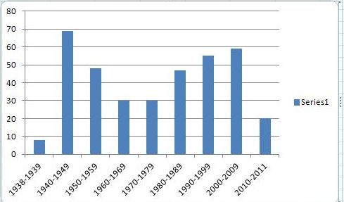
Let's take Ottawa.  The current Environment Canada Archive has daily records for Ottawa from 1938 to 2011.   I have compiled the year in which each day's record high comes from and then grouped by decades.  Here is the result with one caveat and that is with tying years, I only noted the earliest year.   This result is similar, not the same, but similar to US state records, shown at bottom.

As you can see, more than 1/2 of the daily record high temperatures for Ottawa are pre-1980.   It is unfortunate that the rest of the 30's are not included as I am sure that there are many daily records that would still be valid today (think 30's drought/dustbowl, see chart below).   The flip side of this is that 2012 is not included.   This has been an anomalous year, especially March, which as I have explained previously, and corroborated by more official entities, it a result of weather pattern globally over the winter months.   There will be a fair amount of 2012 daily record highs.

Thursday, June 21, 2012

Summer forecast

Some of you may have seen this news article.   Apparently EC has released their summer forecast (June - August).  See any irony folks, considering it's already June 20th?   Most other agencies have released their summer forecast last month.   Anyway EC's forecast is based on these maps. Please note that according to their own stats, they're correct 46.9% of the time(see second map), less than a coin flip.  Below the Canadian model, I will put a few other models outputs for comparison.
Canadian

NOAA
 <> 
Jamstec
NCEP CFS
 
Euro (from B.A. at Accuweather)
 

Wednesday, June 20, 2012

Welcome to Summer

And I don't mean the current heatwave, which is kind of appropriate timing wise I guess.  But the Summer Solstice happens tonight at 7:08 PM EST.  That is the point at which the sun is directly overhead at the most northern latitude, the Tropic of Cancer.   After tomorrow, the days are getting shorter as we slide towards winter.

Tuesday, June 19, 2012

This week and on

No arguments with current EC forecast although we may not get to the current forecast high of 31C today(currently 24 @ 1:40PM).  
Tomorrow will be warm but unsettled.  How unsettled will determine how warm it will get.  More sun, more warm.  More showers, less warm.  
Thursday will be the warmest day, definitely getting well into the 30's.
Friday will bring a cool front which will usher in a period of days of below normal average temps.

Friday, June 15, 2012

Canadian Prairies


There is no drought on the Canadian Prairies, perhaps even too much rain.
Last 30 days percent of normal
Next five days total accumulation

Tuesday, June 12, 2012

Band of precip

7:20 PM update:  Looks like a break in the precip is heading for Ottawa.  Figures.

There is a band of precipitation with thunderstorms embedded that is currently running from Coburg to Petewawa, moving eastward.   If it holds together, it'll hit the Ottawa region in about a couple hours.

Monday, June 11, 2012

This week

Nice and warm today.   We may get some thunder showers popping up this evening but it's not too likely we'll get hit.  The main precip will come early tomorrow into tomorrow afternoon as the cool front comes.
The rest of the week looks fab-u-lous.

Friday, June 8, 2012

The weekend and beyoud

After this afternoon's showers and T-storms clear out, the skies should clear early tomorrow morning.  However a disturbance will pass by south of us Saturday afternoon/evening which may bring us showers (not mentioned in EC's current forecast) .   It should clear up and Sunday and Monday should be nice and warm.   Tuesday will see a frontal system coming through bringing rain.

Wednesday, June 6, 2012